Savoie is a French department in the Auvergne-Rhône-Alpes region, Southeastern France. Located in the French Alps, its prefecture is Chambéry. In 2017, Savoie had a population of 431,174.

Morzine is a commune in the Haute-Savoie department and Auvergne-Rhône-Alpes region of south-eastern France.

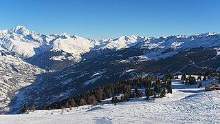
The French Alps are the portions of the Alps mountain range that stand within France, located in the Auvergne-Rhône-Alpes and Provence-Alpes-Côte d'Azur regions. While some of the ranges of the French Alps are entirely in France, others, such as the Mont Blanc massif, are shared with Switzerland and Italy.
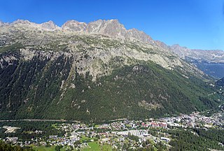
Argentière is a picturesque skiing, alpine walking and mountaineering village in the French Alps, part of the commune of Chamonix-Mont-Blanc, at an altitude of 1,252 m (4,108 ft).

Manigod is a commune in the Haute-Savoie department in the Auvergne-Rhône-Alpes region of Eastern France. In 2018, it had a population of 998.

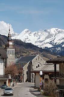
Les Contamines-Montjoie is a commune in the Haute-Savoie department in the Auvergne-Rhône-Alpes region in south-eastern France.

The arrondissement of Annecy is an arrondissement of France in the Haute-Savoie department in the Auvergne-Rhône-Alpes region. It has 79 communes. Its population is 282,319 (2016), and its area is 1,261.6 km2 (487.1 sq mi).
Maurienne is one of the provinces of Savoy, corresponding to the arrondissement of Saint-Jean-de-Maurienne in France. It is also the original name of the capital of the province, now Saint-Jean-de-Maurienne.
La Clusaz is a commune in the Haute-Savoie department in the Auvergne-Rhône-Alpes region in south-eastern France.

Abondance is a commune in the Haute-Savoie department in the Auvergne-Rhône-Alpes region in south-eastern France.
Le Grand-Bornand is a commune in the eastern French department of Haute-Savoie. The commune is a ski resort and takes its name from the river that runs through it. The inhabitants of Le Grand-Bornand are called Bornandins.

Saint-Sorlin-d'Arves is a commune in the Savoie department in the Auvergne-Rhône-Alpes region in south-eastern France.

Menthon-Saint-Bernard, commonly referred to simply as Menthon, is a commune on the eastern shore of Lake Annecy in the Haute-Savoie department in the Auvergne-Rhône-Alpes region in Southeastern France. In 2018, it had a population of 1,884.

Vallorcine is a commune in the Haute-Savoie department in the Auvergne-Rhône-Alpes region in southeastern France. In 2018, it had a population of 404.

Le Reposoir is a commune in the Haute-Savoie department in the Auvergne-Rhône-Alpes region in south-eastern France.

The Fier is a 72.2 km (44.9 mi) long river in the Haute-Savoie and Savoie départements, southeastern France. Its source is at Manigod, in the Aravis Range. It flows generally west. It is a left tributary of the Rhône into which it flows at Seyssel.
The Bornes Massif is a mountainous massif in the north French Prealps in the département of Haute-Savoie. It has 20 peaks higher than 2000 m and is a popular destination for winter sports. The Massif is the source of the celebrated cheese Reblochon.

The Col de la Croix Fry is a mountain pass located in the Chaîne des Aravis, between Manigod and La Clusaz in the Haute-Savoie department of France. The road over the col is used occasionally by the Tour de France cycle race with the tour crossing the pass on Stage 19 of the 2013 Tour. At the summit is the village of La Croix Fry.

The canton of Faverges-Seythenex is an administrative division of the Haute-Savoie department, southeastern France. Its borders were modified at the French canton reorganisation which came into effect in March 2015. Its seat is in Faverges-Seythenex.
