Bluefields International Airport is an airport serving Bluefields, a harbor city in the South Caribbean Coast Autonomous Region of Nicaragua. It is the busiest airport in the Caribbean coast of Nicaragua.
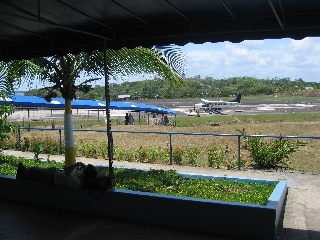
Corn Island International Airport is an airport that serves Great Corn Island on the South Caribbean Coast Autonomous Region. A new terminal has been built and the runway was refurbished so that medium-sized jet aircraft can land the airport. Buses and taxis are both available for transport around the island. It has x-ray machines, two immigration offices.
Esperanza Airport or Peñuela Airport is an airport 2 kilometres (1.2 mi) east of Esperanza, a city in the Valverde Province of the Dominican Republic.
Punta Huete Airport is an airport located in the municipality of San Francisco Libre in Managua, Nicaragua. The airport is in a sparsely populated section of the municipality. The nearest town is San Benito, 14 kilometres (9 mi) to the east.
Chinandega Airport is an airport serving Chinandega, the capital of the Chinandega Department of Nicaragua. The airport is on the northwest edge of the city.
León Airport is an airport serving León, the capital of the León Department of Nicaragua. The airport is on the southwest side of the city.
Los Brasiles Airport is an airport serving Mateare, a municipality of the Managua Department of Nicaragua. The airport is 2 kilometres (1 mi) west of the Lake Managua shoreline and 4 kilometres (2 mi) south of the Apoyeque volcano.
Montelimar Airport is an airport serving the municipality of San Rafael del Sur, Nicaragua.
San Juan de Nicaragua Airport is an airport located in San Juan de Nicaragua, Río San Juan, Nicaragua. The airport was built in 2012 at a cost of almost US$17 million.

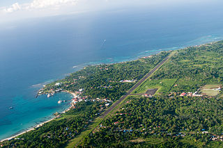
Ometepe Airport is the only airport on Ometepe, the largest island in Lake Nicaragua. The airport is in the La Paloma comarca of Moyogalpa, Rivas Department, Nicaragua, 1.6 kilometres (1 mi) south of Moyogalpa.
Emerald Coast Airport is an international airport 10 kilometres (6.2 mi) west of Tola, a town in the Rivas Department of Nicaragua. The airport was opened on November 15, 2015 at a cost of almost US$13 million.
La Esperanza Airport is an airport serving a number of agricultural villages and towns in western Colón Department, Honduras. The largest nearby towns are Sonaguera (13 km) and Sabá (17 km).
La Chepona Airport is an airstrip serving the village of La Chepona in Usulután Department, El Salvador. The airstrip and village are on an estuarian island just east of the Jiquilisco Bay.
Upala Airport is an airport serving the town of Upala in Alajuela Province, Costa Rica. Upala is 10 kilometres (6 mi) south of the Nicaragua border.
Karawala Airport is an airstrip serving the village of Karawala in the South Caribbean Coast Autonomous Region of Nicaragua. The airstrip is 6 kilometres (4 mi) inland from the Caribbean coast.
El Bluff Airport was an airport on El Bluff, once an island in the entrance to Bluefields Bay, South Caribbean Coast Autonomous Region, Nicaragua, but now connected to the mainland via a causeway constructed between 2004 and 2007. Google Earth Historical Imagery show progressive deterioration of the asphalt runway until a helicopter pad and hangar were built on the southwestern end in 2013. The hangar was torn down and the helipad markings removed sometime after 2015.
La Cumplida Airport is an airport serving the village of La Cumplida in Matagalpa Department, Nicaragua.
Palcasa Airport is an airport serving the town of El Castillo in Río San Juan Department, Nicaragua. The airport is 5.5 kilometres (3.4 mi) north of El Castillo, midway between the small towns of La Palma and Las Colinas. It is surrounded by and supports the palm oil plantations of Palmares del Castillo S.A. (PALCASA).
Putumayo Airport is an airport serving the Putumayo River village of Puerto El Carmen de Putumayo in Sucumbíos Province, Ecuador. The runway is in a bend of the river 1 kilometre (0.6 mi) east of the village.
Puerto Esperanza Airport is an airport serving the town of Esperanza in the Ucayali Region of Peru. The town is on the Purus River.
