Pontevedra is a city in the autonomous community of Galicia, in northwestern Spain. It is the capital of both the Comarca and Province of Pontevedra, and the capital of the Rías Baixas. It is also the capital of its own municipality which is often considered an extension of the actual city.

The Rías Baixas are a series of four estuarine inlets located on the southwestern coast of Galicia, Spain. They are the Ría de Muros e Noia, the Ría de Arousa, the Ría de Pontevedra, and the Ría de Vigo. The northernmost Rías Baixas begin below Cape Finisterre while the southernmost rias border the Portuguese coast, taking up the southern part of the Province of Coruña and the entire Province of Pontevedra. Its capital is the city of Pontevedra. Due to unique conditions, the Rías Baixas are rich in marine life which helps the fishing and aquaculture industry of the area. Beaches, marinas, distinctive towns, and plenty of water activities also attract tourists, providing another source of income.

O Grove is a municipality belonging to the province of Pontevedra, in Galicia, Spain.
Sanxenxo is a municipality in Galicia, Spain in the province of Pontevedra.

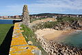
The Ons Island is the main island of a small archipelago in the Ria de Pontevedra in Galicia, Spain. Ons belongs administratively to the municipality of Bueu, which has a regular ferry boat connection to the island, as have the mainland towns of Portonovo, Sanxenxo, Marín and Aldán. In 2020, lightning due to Subtropical Storm Alpha started a forest fire.

The Atlantic Islands of Galicia National Park is the only national park located in the province of Pontevedra, in the autonomous community of Galicia, Spain. It comprises the archipelagos of Cíes, Ons, Sálvora and Cortegada. The park covers a land area of 1,200 ha and a sea area of 7,200 ha. It is the tenth most visited national park in Spain. It was the thirteenth national park to be established in Spain. Since 2021 it has been designated as a protected Ramsar site.

The Burgo Bridge(Puente del Burgo) is a medieval bridge, built over an older bridge of Roman origin, which crosses the Lérez River in the city of Pontevedra, Spain. It is on the route of the Portuguese Way to the north of the historic centre of Pontevedra and to the south of the Burgo neighbourhood. Between the arches above the pillars are carved the famous stone pilgrim's shells.

The Palace of Mugartegui, or Palace of the Counts of Fefiñáns in Pontevedra, Spain, is a Baroque pazo dating from the 18th century. It currently houses the headquarters of the Regulatory Council of the Rías Baixas Designation of Origin.

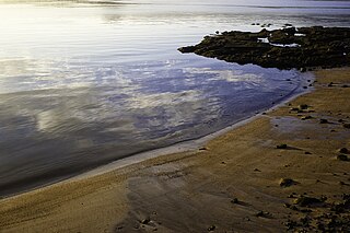
The Lérez beach is a Galician beach located in the municipality of Pontevedra in the province of Pontevedra, Spain. It is a semi-urban river beach with a length of 100 metres.
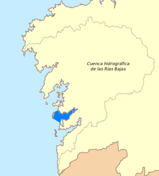
The Ria de Pontevedra is located in the Province of Pontevedra, in Galicia, Spain. It is one of the three main maritime entrances of Galicia, the Rías Baixas, the most touristic area of the region. It is also the most regular of them and the third largest of all those in Galicia with a surface area of 145 km2 (56 sq mi).

The Mendoza mansion is a building located between Santa María Avenue and Arzobispo Malvar Street, at the western end of the old town of Pontevedra. It is currently the headquarters of the Rias Bajas Tourist Office.

The Plaza de Toros de Pontevedra (Spain) is the bullring of the Spanish city of Pontevedra and the only one in the autonomous community of Galicia. It has a capacity of 7,800 spectators and is classified as the second category of Spanish bullring. The current bullring replaced a wooden one dating from 1892, although the tradition of bullfighting in Pontevedra dates back to the 17th century.
The Montalvo beach is a Galician beach located in the municipality of Sanxenxo in the province of Pontevedra, Spain. It is 1000 metres long and 80 metres width at low tide and 20 at high tide and has views over the Ria de Pontevedra.

The Tambo Island is an island in the middle of the Pontevedra bay, in Spain. It belongs to the municipality of Poio, from which it is separated by a 1.1 km long but shallow channel. Its surface area is 0.28 km2, with a maximum height of 80 m, although its entire central part is over 50 metres high. Its perimeter reaches 4 km.

The Archiepiscopal Towers Interpretation Centre (CITA)(Centro de Interpretación das Torres Arcebispais (CITA)) is a museum in Pontevedra, Spain created in 2010 in the former moat of the Archiepiscopal Towers fortress-palace in the old town. The museum focuses on the interpretation of what was one of the most important monuments and defensive structures of the city, the Archbishop's Towers, which were part of the Ramparts of Pontevedra.

A Toxa is an island part of the municipality of O Grove, Galicia, Spain. Located east of the town, it's connected to the mainland by an 18th-century bridge. It has a small urban centre called Illa da Toxa, belonging to the civil parish of San Martín, which had 42 inhabitants in 2018. It has an area of 110 hectares and is located about 30 km from Pontevedra.

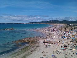
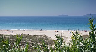
The Areas Beach is a Galician beach belonging to the municipality of Sanxenxo in the province of Pontevedra, Spain. It is 700 metres long and is located in the ria de Pontevedra, 15 km from Pontevedra.

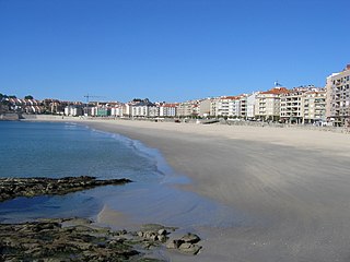
The Silgar beach is a Galician beach located on the urban coastline of the municipality of Sanxenxo in the province of Pontevedra, Spain. It is 750 metres long and is bordered from end to end by the eponymous promenade.

The paseo marítimo of Pontevedra is a pedestrian way along the seafront facing the ria of Pontevedra, in Pontevedra, Spain. This coastal public space is built in the urban and semi-urban area of the city and defines its encounter with the sea and the Lérez river.
Placeres Beach or A Posta Beach is a Galician beach located in the Spanish municipality of Pontevedra, in the province of Pontevedra. It is a semi-urban coastal beach 50 metres long.