Related Research Articles

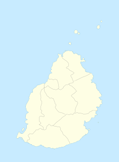
Mauritius, officially the Republic of Mauritius, is an island nation in the Indian Ocean about 2,000 kilometres (1,200 mi) off the southeast coast of the African continent, east of Madagascar. It includes the main island, as well as Rodrigues, Agaléga and St. Brandon. The islands of Mauritius and Rodrigues, along with nearby Réunion, are part of the Mascarene Islands. The capital and largest city, Port Louis, is located in Mauritius, where most of the population is concentrated. The country spans 2,040 square kilometres (790 sq mi) and has an exclusive economic zone covering 2.3 million square kilometres.

Amherst is a village in Buffalo County, Nebraska, United States. It is part of the Kearney, Nebraska Micropolitan Statistical Area. The population was 248 at the 2010 census.

Union is a village in Cass County, Nebraska, United States. The population was 233 at the 2010 census.

Ruskin is a village in Nuckolls County, Nebraska, United States. The population was 123 at the 2010 census.

Rockland is a village in eastern La Crosse County, Wisconsin, United States, along the La Crosse River. It is part of the La Crosse, Wisconsin Metropolitan Statistical Area. The population was 594 at the 2010 census.

Onalaska is a city in La Crosse County, Wisconsin, United States. The population was 17,736 at the 2010 census. It borders the larger La Crosse, Wisconsin, and is a part of the La Crosse-Onalaska, WI-MN Metropolitan Area.

Couderay is a village in Sawyer County, Wisconsin, United States, along the Couderay River. The population was 88 at the 2010 census. The village is located within the Town of Couderay.
Moka is a village in Mauritius located in the Moka District, the western part of the village also lies in the Plaines Wilhems District. The village is administered by the Moka Village Council under the aegis of the Moka District Council. According to the census made by Statistics Mauritius in 2011, the population was at 8,846. The elevation is 203 meters and can be up to 425 meters in some places. Moka is directly on the other side of the Moka Range from Port Louis. The village is close to the mountain Le Pouce and the town Beau-Bassin Rose-Hill. Réduit is a suburb of the village where the State House and University of Mauritius is situated. The village is also home to the Mauritius Broadcasting Corporation and the Mahatma Gandhi Institute.

Isle de France was the name of the Indian Ocean island which is known as Mauritius and its dependent territories between 1715 and 1810, when the area was under the French East India Company and part of France's empire. Under the French, the island witnessed major changes. The increasing importance of agriculture led to the importation of slaves and the undertaking of vast infrastructural works that transformed Port Louis into a major capital, port, warehousing, and commercial centre.

Grand Port is a district of Mauritius, situated in the east of the island. The name means "large port" in French. The district has an area of 260.3 km2 and the population estimate was at 112,997 as of 31 December 2015.

Laura Pausini is an Italian singer-songwriter and television personality. As a child, she was encouraged by her father to join him during his performances in local piano bars. After competing in local singing contests, Pausini signed her first recording contract. She rose to fame in 1993, winning the newcomer artists' section of the 43rd Sanremo Music Festival with her debut single "La solitudine", which became an Italian standard and an international hit, topping the charts in the Netherlands, and Belgium. Her self titled debut album was released in Italy on 23 April 1993 and later became an international success, selling two million copies worldwide.
Outer Islands of Mauritius is the single first-order administrative division of the country and consists of the islands of Mauritius and several outlying islands. It is under the responsibility of the Ministry of Local Government and Outer Islands. The Constitution of Mauritius provides that the country includes the islands of Mauritius, Rodrigues, Agaléga, Saint Brandon, Tromelin and the Chagos Archipelago, including Diego Garcia and any other island comprised in the State of Mauritius. The Government of Mauritius claims sovereignty over the Chagos Archipelago, which the United Kingdom split from its territories to create the British Indian Ocean Territory before its independence in 1968. Additionally, France shares a sovereignty claim over Tromelin, an uninhabited islet between Madagascar and Mauritius' main island.

Flacq is a district of Mauritius, situated in the east of the island. It is the largest district, having an area of 297.9 km², the population estimate was at 138,460 as at 31 December 2015.

Tamarin is a village on the western coast of Mauritius. It has long been the seat of the council district of Rivière Noire. The district council has recently been moved to new headquarters in Bambous, this village being more accessible to the villagers.
The village of Port Mathurin serves as the capital of the island of Rodrigues, a dependency of Mauritius. It lies on the north coast of the Indian Ocean island and functions as the administrative, judicial and economic centre of Rodrigues. As the name suggests, it also operates the main harbour of the island.
Cammo is a northwestern suburb of Edinburgh, the capital of Scotland. It is south of A90, at the edge of the city, approximately 6 miles from the city centre.

Trou-aux-Biches is a small town with a public beach on the northern coast of Mauritius in the district of Pamplemousses. According to the World Travel group, the beach is one of the most beautiful on the island. They awarded it the World's Leading Beach Destination at the World Travel Award for 2011. Many tourist resorts and boutique hotels are situated near the beach, such as the Trou aux Biches Resort & Spa. From Port Louis, the M2 highway heads towards it, with Trou-aux-Biches about 1.5 kilometres (1 mi) west from the end of M2. The airport and the town are connected by a public bus.

The 1995–96 Australian region cyclone season was an active Australian cyclone season, with Western Australia experiencing a record number of landfalling intense storms in the Pilbara region. The season produced a total of 19 tropical cyclones, of which 14 developed into named storms and 9 reached severe tropical cyclone status. The strongest of the season was Severe Tropical Cyclone Olivia, which also produced the highest recorded wind gust on record of 408 km/h (253 mph). Though several systems impacted land, the general sparsity of population centres in Australia limits the scale of damage. One person was confirmed to have been killed and cumulative losses were estimated at A$77 million (US$58.5 million).

Le Pouce is the third highest mountain in Mauritius, at 812 meters. Only Piton de la Petite Rivière Noire and Pieter Both are taller. It is named Le Pouce because of the thumb-shaped peak of the mountain. It can be viewed from the capital of Mauritius, Port Louis, and is a popular hike for the view of the city. The mountain is in the Moka Range and is closest to the village of La Laura-Malenga in the Moka District. Charles Darwin ascended the mountain on 2 May 1836.
The English River Dene Nation is a Dene First Nation band government in Patuanak, Saskatchewan, Canada. Their reserve is in the northern section of this Canadian province. Its territories are in the boreal forest of the Canadian Shield. This First Nation is a member of the Meadow Lake Tribal Council (MLTC).
References
- ↑ "World Gazetteer: La Laura-Malenga - profile of geographical entity including name variants". World Gazetteer. Archived from the original on 10 February 2013. Retrieved 3 March 2012.
- ↑ Bhurdwaz Mungur; Breejan Burrun (1993). An invitation to the charms of Mauritian localities: a survey of names and attractions of places in Mauritius. ELP Ltée. ISBN 978-99903-23-03-0 . Retrieved 29 February 2012.
Coordinates: 20°12′18″S57°33′00″E / 20.205°S 57.55°E
| | This Mauritius location article is a stub. You can help Wikipedia by expanding it. |