
Jenny Lind is an unincorporated community in Calaveras County, California. It lies at an elevation of 253 feet and is located at 38°6′N120°52′W. The community is in ZIP code 95252 and area code 209.
The Shores of Poker Flat is an unincorporated community in Calaveras County, California. It lies at an elevation of 584 feet above sea level and is located at 37°54′11″N120°34′56″W, on the shore of the Tulloch Reservoir. The community is in ZIP code 95228 and area code 209.
The Estrella River is a 28.5-mile-long (45.9 km) tributary river in eastern San Luis Obispo County, California. The river forms at the confluence of Cholame Creek, from the north, and San Juan Creek, from the south, near the town of Shandon. From there it flows west-northwest to its confluence with the Salinas River, of which it is a tributary, 8 miles north of Paso Robles. Cholame Creek has its headwaters on the southwest side of Middle Mountain and its tributary, Little Cholame Creek, begins on the northeast side. The creek drains the Cholame Valley, which is bordered by Diablo Range on the east and Cholame Hills, a northern extension of the Temblor Range, on the west. The average precipitation in the area ranges from 11 to 17 inches, increasing northward.
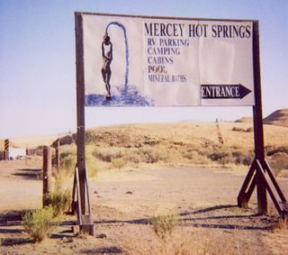
Mercey Hot Springs is an unincorporated community in the Little Panoche Valley of Fresno County, central California, about 60 miles (97 km) west-southwest of Fresno. It is a resort along South Fork Little Panoche Creek and the Little Panoche Road located at the western edge of Fresno County.
La Grange is a small unincorporated community in rural Stanislaus County, California, United States. Its altitude is 249 feet (76 m). As of 2008 it has a population of 345. It is located at 37°39′49″N120°27′49″W along the Tuolumne River, and is near the La Grange Dam and the New Don Pedro Dam.

Havilah is an unincorporated community in Kern County, California. It is located in the mountains between Walker Basin and the Kern River Valley, 5 miles (8.0 km) south-southwest of Bodfish at an elevation of 3,136 feet (956 m).
Canyon View is an unincorporated community in Calaveras County, California. It lies at an elevation of 3097 feet.
Gold Hill is an unincorporated community in El Dorado County, California. It is located 2.5 miles (4.0 km) south of Coloma, at an elevation of 1621 feet.
Latrobe is an unincorporated community in El Dorado County, California. It is located 15 miles (24 km) southwest of Placerville, at an elevation of 761 feet.

Jawbone Canyon is a geographic feature in the Mojave Desert and a Bureau of Land Management area located in Kern County, California, 20 miles (32 km) north of Mojave on CA 14. The area is a popular destination for hikers and off road vehicle enthusiasts.
Etta is an unincorporated community in Caroline County, in the U.S. state of Virginia.
Lingo Canyon is a canyon in San Luis Obispo county in California.
Temescal Mountains, formerly the Sierra Temescal, are one of the northernmost mountain ranges of the Peninsular Ranges in western Riverside County, in Southern California in the United States. They extend for approximately 25 mi (40 km) southeast of the Santa Ana River east of the Elsinore Fault Zone to the Temecula Basin and form the western edge of the Perris Block.
San Felipe Creek is a stream in Imperial and San Diego Counties of California. It arises in the Volcan Mountains of San Diego County 33°11′57″N116°37′35″W, and runs eastward, gathering the waters of most of the eastern slope of the mountains and desert of the county before it empties into the Salton Sea. It is probably the last remaining perennial natural desert stream in the Colorado Desert region. In 1974, the San Felipe Creek Area was designated as a National Natural Landmark by the National Park Service.
Cuba is a ghost town in Cass County, in the U.S. state of Minnesota. Cuba was named after the island of Cuba, a location in the Spanish–American War.
Camatta Creek, originally Arroyo Camate, in 19th century Alta California, is a tributary stream of San Juan Creek, itself a tributary of the Estrella River, in San Luis Obispo County.
San Juan Creek is a tributary stream of the Estrella River in San Luis Obispo County, California.
See Canyon is a valley in San Luis Obispo County, California. It has its source at 35°15′09″N120°46′16″W at an elevation of 960 feet / 291 meters in the Irish Hills. Its mouth lies at an elevation of 33 feet / 10 meters, at its confluence with San Luis Obispo Creek.
Joaquin Ridge is a ridge in the Diablo Range in Fresno County, California. The ridge is named for Joaquin Murietta (1830-1853), a California Gold Rush bandit, leader of the Five Joaquins Gang, who used this region as a rendezvous and camp that overlooked the gangs base at the Rancho de Cantua. The ridge is ten miles long, running from its high point at 36°19′48″N120°34′09″W, east of Spanish Lake, eastward to Joaquin Rocks 36°19′11″N120°27′32″W, and then southwestward to 36°18′15″N120°24′11″W near Black Mountain the high point on Anticline Ridge. Joaquin Ridge is bound on the northeast by the Big Blue Hills and on the southwest by Portuguese Canyon. Its highest elevation 4,701 feet / 1,433 meters, is 0.64 km east of Spanish Lake.


