
Oaxaca, officially the Free and Sovereign State of Oaxaca, is one of the 32 states that compose the Federative Entities of the United Mexican States. It is divided into 570 municipalities, of which 418 are governed by the system of usos y costumbres with recognized local forms of self-governance. Its capital city is Oaxaca de Juárez.
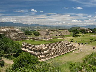
Oaxaca de Juárez, or simply Oaxaca, is the capital and largest city of the eponymous Mexican state of Oaxaca. It is the municipal seat for the surrounding municipality of Oaxaca, the most populous municipality in Oaxaca and the fourth most densely populated municipality in Oaxaca, only being less densely populated than San Jacinto Amilpas, Santa Lucía del Camino, and Santa Cruz Amilpas. It is in the Centro District in the Central Valleys region of the state, in the foothills of the Sierra Madre at the base of the Cerro del Fortín, extending to the banks of the Atoyac River.
Ejutla de Crespo is a city and a municipality of the same name, in the central valleys of the Mexican state of Oaxaca. It is part of the Ejutla District in the south of the Valles Centrales Region.
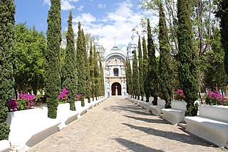
Ocotlán de Morelos is a town and municipality in the state of Oaxaca, about 35 km south of the center of the city of Oaxaca along Highway 175. It is part of the Ocotlán District in the south of the Valles Centrales Region. The area was a significant population center at the time of the Spanish Conquest, and for that reason an important Dominican monastery was established here in the 16th century. The complex still exists, with the church still being used for worship and the cloister area used as a museum. While mostly quiet, the city is an important distribution and transportation center for the south of the Central Valleys region of Oaxaca, a function which is expected to be reinforced with the opening of new highway being built to connect the city of Oaxaca with the Pacific coast. The city is known for artist Rodolfo Morales, who painted aspects of his hometown in his works and sponsored projects to save and restore historic monuments here. For generations the municipality has been known for its crafts, with the ceramics making Aguilar family producing some of the best known craftsmen.
Coatecas Altas is a town and municipality in Oaxaca in south-western Mexico. The municipality covers an area of 125.03 km2. It is part of the Ejutla District in the south of the Valles Centrales Region.
La Compañía is a town and municipality in Oaxaca in southern Mexico. The municipality covers an area of 93.13 km2. It is part of the Ejutla District in the south of the Valles Centrales Region.
San Agustín Amatengo is a town and municipality in Oaxaca in south-western Mexico. The municipality covers an area of 58.69 km². It is part of the Ejutla District in the south of the Valles Centrales Region.
San Andrés Zabache is a town and municipality in Oaxaca in south-western Mexico. The municipality covers an area of 35.72 km². It is part of the Ejutla District in the south of the Valles Centrales Region.
San Juan Lachigalla is a town and municipality in Oaxaca in south-western Mexico. The municipality covers an area of 136.51 km². It is part of the Ejutla District in the south of the Valles Centrales Region.
San Martín de los Cansecos is a town and municipality in Oaxaca in south-western Mexico. The municipality covers an area of 45.93 km². It is part of the Ejutla District in the south of the Valles Centrales Region.
San Martín Lachilá is a town and municipality in Oaxaca in south-western Mexico. The municipality covers an area of 49.76 km2. It is part of the Ejutla District in the south of the Valles Centrales Region.
San Miguel Ejutla is a town and municipality in Oaxaca in south-western Mexico. The municipality covers an area of 40.83 km². It is part of the Ejutla District in the south of the Valles Centrales Region.
San Nicolás is a town and municipality in Oaxaca in south-western Mexico. The municipality covers an area of 29.34 km². It is part of the Miahuatlán District in the south of the Sierra Sur Region. As of 2005, the municipality had a total population of 632.
Yogana is a town and municipality in Oaxaca in south-western Mexico. The municipality covers an area of km². It is part of the Ejutla District in the south of the Valles Centrales Region.
Taniche is a town and municipality in Oaxaca in south-western Mexico. The municipality covers an area of 22.97 km². It is part of the Ejutla District in the south of the Valles Centrales Region.
San Sebastián Nicananduta is a town and municipality in Oaxaca in south-western Mexico. The municipality covers an area of km2. It is part of the Teposcolula District in the center of the Mixteca Region
San Sebastián Tutla is a town and municipality in Oaxaca in south-western Mexico. The municipality covers an area of 8.93 km². It is part of the Centro District in the Valles Centrales region. As of 2010, the municipality had a total population of 16,241.

Ejutla District is located in the south of the Valles Centrales Region of the State of Oaxaca, Mexico.
Juchitán District is located in the east of the Istmo de Tehuantepec region of the State of Oaxaca, Mexico and the easternmost district in Oaxaca, covering the southern part of a low-lying corridor through the mountains that separates the Gulf of Mexico from the Pacific Ocean. The district has an area of 13,300 km2 and a population as of 2005 of 339,445.

The 9th federal electoral district of Oaxaca is one of the 300 electoral districts into which Mexico is divided for elections to the federal Chamber of Deputies and one of 10 such districts in the state of Oaxaca.

