
El Camino Real is a 600-mile (965-kilometer) commemorative route connecting the 21 Spanish missions in California, along with a number of sub-missions, four presidios, and three pueblos. Historically associated with a network of royal roads used by inhabitants of New Spain, the modern commemorative route in the U.S. state of California is named after these roads, with its southern terminus at Mission San Diego de Alcalá and its northern terminus at Mission San Francisco Solano in Sonoma, California.
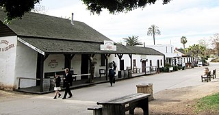
Old Town San Diego State Historic Park is a state protected historical park in the Old Town neighborhood of San Diego, California. The park commemorates the early days of San Diego; it includes many historic buildings from the period 1820 to 1870. The park was established in 1968. In 2005 and 2006, California State Parks listed Old Town San Diego as the most visited state park in California.

State Route 209 (SR 209) was a state highway in the U.S. state of California, connecting Cabrillo National Monument with the interchange of Interstate 5 (I-5) and I-8 in San Diego, passing through the neighborhoods of Point Loma. The majority of the route was along Rosecrans Street; it also included Cañon Street and Catalina Boulevard leading to the tip of Point Loma.
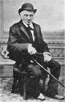
Louis Rose was a pioneer developer of San Diego, California. The neighborhood of Roseville in Point Loma is named for him, as are Rose Creek and Rose Canyon.
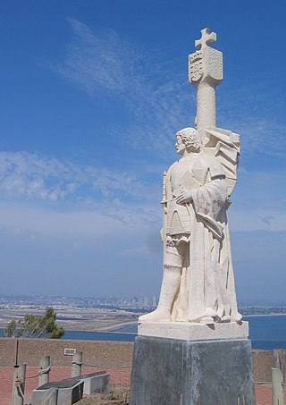
Cabrillo National Monument is a national monument at the southern tip of the Point Loma Peninsula in San Diego, California, United States. It commemorates the landing of Juan Rodríguez Cabrillo at San Diego Bay on September 28, 1542. This event marked the first time a European expedition had set foot on what later became the West Coast of the United States. The site was designated as California Historical Landmark #56 in 1932. The area was listed on the National Register of Historic Places on October 15, 1966.

The Old Spanish Trail was an auto trail that once spanned the United States with almost 2,750 miles (4,430 km) of roadway from ocean to ocean. It crossed eight states and 67 counties along the southern border of the United States. Work on the auto highway began in 1915 at a meeting held at the Battle House Hotel in Mobile, Alabama; and, by the 1920s, the trail linked St. Augustine, Florida, to San Diego, California, with its center and headquarters in San Antonio, Texas. The work at San Antonio, and indeed nationally, was overseen by an executive committee consisting of prominent San Antonio businessmen which met at the Gunter Hotel weekly.
The culture of San Diego is influenced heavily by American and Mexican cultures due to its position as a border town, its large Hispanic population, and its history as part of Spanish America and Mexico. San Diego's longtime association with the U.S. military also contributes to its culture. Present-day culture includes many historical and tourist attractions, a thriving musical and theatrical scene, numerous notable special events, a varied cuisine, and a reputation as one of America's premier centers of craft brewing.

Point Loma is a seaside community in San Diego, California, United States. Geographically it is a hilly peninsula that is bordered on the west and south by the Pacific Ocean, the east by San Diego Bay and Old Town, and the north by the San Diego River. Together with the Silver Strand/Coronado peninsula, the Point Loma peninsula defines San Diego Bay and separates it from the Pacific Ocean. The term "Point Loma" is used to describe both the neighborhood and the peninsula.

Naval Base Point Loma (NBPL) is a United States Navy base in Point Loma, a neighborhood of San Diego, California. It was established on 1 October 1998 when Navy facilities in the Point Loma area of San Diego were consolidated under Commander, Navy Region Southwest. Naval Base Point Loma consists of seven facilities: Submarine Base, Naval Mine and Anti-Submarine Warfare Command, Fleet Combat Training Center Pacific, Naval Information Warfare Systems Command (NAVWAR), Naval Information Warfare Center Pacific, the Fleet Intelligence Command Pacific and Naval Consolidated Brig, Miramar. These close-knit commands form a diverse and highly technical hub of naval activity. The on-base population is around 22,000 Navy and civilian personnel.

Old Town is a neighborhood in San Diego, California. It contains 230 acres (93 ha) and is bounded by Interstate 8 on the north, Interstate 5 on the west, Mission Hills on the east and south. It is the oldest settled area in San Diego and is the site of the first European settlement in present-day California. It contains Old Town San Diego State Historic Park and Presidio Park, both of which are listed on the National Register of Historic Places.

Fort Guijarros was a Spanish fort in what is now San Diego, California, United States. Its name means "Fort Cobblestones" in English. It was built in 1797 on Ballast Point as the first defensive fortifications for San Diego Bay. It was involved in the Battle of San Diego, a naval battle between the fort and an American trading vessel. The site is registered as California Historical Landmark #69.

Midway is a neighborhood in San Diego, California. It is located at the northern (mainland) end of the Point Loma peninsula, northwest of downtown San Diego, and just west of Old Town. It is often considered to be part of Point Loma, although the city treats it as a separate planning area.
La Playa is a bayfront neighborhood in the Point Loma community of San Diego, California. It is bordered by San Diego Bay to the east, Naval Base Point Loma to the south, the Wooded Area neighborhood to the west and Point Loma Village/Roseville-Fleetridge to the north. It lies across a channel from Shelter Island.
Loma Portal is a neighborhood in the community of Point Loma in San Diego, California. It is a hilly area northwest of Rosecrans Street and northeast of Nimitz Boulevard, overlooking San Diego Bay.
Roseville-Fleetridge is a neighborhood in Point Loma, a community of San Diego, California. It is bounded by San Diego Bay and Rosecrans Street to the east, Cañon Street to the south, Catalina Boulevard to the west and Chatsworth and Nimitz Boulevards to the north. Neighboring communities are Point Loma Heights and Loma Portal to the north, Point Loma Village and Liberty Station to the east, La Playa and the Wooded Area to the south, and Sunset Cliffs to the west. It is actually two separate neighborhoods, Roseville and Fleetridge, which the city lumps together for policing purposes.

The Wooded Area is a neighborhood in Point Loma, a community of San Diego, California. It encompasses the hilltop area south of Talbot Street on both sides of Catalina Boulevard; the area west of Catalina is also referred to as the College Area. The Wooded Area borders Naval Base Point Loma to the south, La Playa to the east, Roseville-Fleetridge to the north, and Sunset Cliffs and Point Loma Nazarene University to the west. The boundaries of the neighborhood are not universally agreed upon, with different maps showing different borders.
The following is a timeline of the history of San Diego, California, United States.

Point Loma Heights is a neighborhood in Point Loma, a community of San Diego, California. It is bounded by Froude Street on the west, Point Loma Avenue and Chatsworth Boulevard on the south, Nimitz Boulevard on the east and Midway Drive and the San Diego River on the north. Neighboring communities are Ocean Beach to the west, Sunset Cliffs and Roseville-Fleetridge to the south, Loma Portal to the east, and Midway and Mission Bay Park to the north.
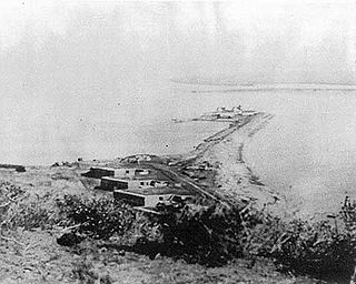
Ballast Point Whaling Station in San Diego, California, in San Diego County, is a California Historical Landmark No. 50 listed on December 6, 1935. The Ballast Point Whaling Station was built in 1858 by Captain Miles A. Johnson his cousins, Henry and James A. Johnson and the twin Packard brothers, Alpheus and William, brothers. The Portuguese-American Johnsons, Alpheus and William came to San Diego from Massachusetts in 1856. The Ballast Point Whaling Station was on Ballast Point. The whaling station processed whales to make whale oil. Whale oil was a very popular as in oil lamps it produced little smoke. Whale oil was also used in miner's headlamps, lighthouses, soaps, and candles, and as machinery lubricant. In 1869 the United States acquired the site for a quarantine station and built a lighthouse and later Fort Rosecrans, named after Major General William Rosecrans. Whaling operations at Ballast Point stopped in 1873. In 1946 the site became a U.S. Navy submarine base. The site today is Naval Base Point Loma founded in 1959. A Ballast Point Whaling Station historic marker is located on the Navy Base. Before Ballast Point Whaling Station the site was the Spanish Fort Guijarros

El Desembarcadero, or The Landing, is a historical site in San Diego, California, in San Diego Bay. The El Desembarcadero site is a California Historical Landmark No. 64 listed on December 6, 1932. It is the site of the landing by Spaniards coming to New Spain, Pueblo de San Diego, now Old Town, San Diego. Small ship's boats brought cargo and passengers to the San Diego Mission, Presidio of San Diego and Pueblo San Diego. It most likely that ships San Antonio and San Carlos landed at the site in 1769, looking fresh water on the San Diego River, on their San Diego expedition. San Antonio arrived in San Diego Bay on April 11, 1769, and the San Carlos on April 29. They landed on May 1, 1769, Some of the ships grew died in San Diego and Father Serra and Father Vila, remain in San Diego. T
