La Yarada-Los Palos District

Last updated
La Yarada-Los Palos District
Distrito de La Yarada-Los Palos.svg
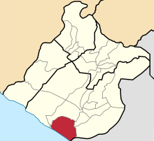
Location of the La Yarada-Los Palos District in the Tacna province
Country Flag of Peru.svg  Peru
Region Tacna
Province Tacna
Founded2015
Capital Los Palos
Area
  Total2,320 km2 (900 sq mi)
Elevation
62 m (203 ft)
Population
  Total16,432
  Density7.1/km2 (18/sq mi)
Time zone UTC-5 (PET)

The district of La Yarada Los Palos is one of the 11 districts that constitute the province of Tacna in the Tacna Region, in the south of Peru.

Contents

History

On November 7, 2015, the President of Peru promulgated Law No. 30358, law creating the district of Yarada los Palos. The territorial limits of the district were defined as follows:

[...] on the northwest, [the province] limits with the district of Tacna, the limit begins in the coast, in a UTM coordinate point 333 220 m E and 7 985 129 m N; in the northeast it borders the district of Tacna, in the east it borders the district of Tacna, in the south it borders the Republic of Chile, along the frontier line, until its intersection with the Pacific Ocean in the Concordia milestone, point of beginning of the land border, in accordance with the provisions of the Treaty of Lima and its Supplementary Protocol, between Peru and Chile, dated June 3, 1929, and the work of the Mixed Boundary Commission of 1929 and 1930; and from the west, starting from the Concordia point, starting point of the land border with the Republic of Chile, bordering the Pacific Ocean, following the low tide line to a coordinate point UTM 333 220 m E and 7 985 129 m N, starting point of the present description. All this, also, with respect to the maritime boundary with Chile, defined by the ruling of the International Court of Justice of January 27, 2014 and the coordinates determined by virtue of the work carried out by technicians from both countries, which are included in the Minutes. signed in Lima, on March 25, 2014. [1]

Chile protested against the creation of the district due to the dispute between both countries, and declared it null and void in the context of the border between both states. [2]
Climate

Climate data for La Yarada (elevation 30 m (98 ft), 1991–2020 normals)
MonthJanFebMarAprMayJunJulAugSepOctNovDecYear
Mean daily maximum °C (°F)27.5
(81.5)
28.0
(82.4)
27.2
(81.0)
25.1
(77.2)
23.0
(73.4)
20.9
(69.6)
19.8
(67.6)
19.8
(67.6)
20.5
(68.9)
22.2
(72.0)
24.0
(75.2)
25.8
(78.4)
23.7
(74.6)
Mean daily minimum °C (°F)18.8
(65.8)
18.9
(66.0)
17.7
(63.9)
15.6
(60.1)
14.5
(58.1)
14.0
(57.2)
13.7
(56.7)
14.0
(57.2)
14.6
(58.3)
15.4
(59.7)
16.6
(61.9)
17.6
(63.7)
16.0
(60.7)
Average precipitation mm (inches)0.4
(0.02)
0.4
(0.02)
0.2
(0.01)
0.0
(0.0)
0.0
(0.0)
0.3
(0.01)
1.0
(0.04)
0.9
(0.04)
0.6
(0.02)
0.2
(0.01)
0.0
(0.0)
0.2
(0.01)
4.2
(0.18)
Source: National Meteorology and Hydrology Service of Peru [3]

See also

Related Research Articles

<span class="mw-page-title-main">Geography of Peru</span>

Peru is a country on the central western coast of South America facing the Pacific Ocean. It lies wholly in the Southern Hemisphere, its northernmost extreme reaching to 1.8 minutes of latitude or about 3.3 kilometres (2.1 mi) south of the equator. Peru shares land borders with Ecuador, Colombia, Brazil, Bolivia, and Chile, with its longest land border shared with Brazil.

<span class="mw-page-title-main">War of the Pacific</span> Territorial conflict between Chile and allied Peru and Bolivia (1879–83)

The War of the Pacific, also known as the Nitrate War and by multiple other names, was a war between Chile and a Bolivian–Peruvian alliance from 1879 to 1884. Fought over Chilean claims on coastal Bolivian territory in the Atacama Desert, the war ended with victory for Chile, which gained a significant amount of resource-rich territory from Peru and Bolivia.

<span class="mw-page-title-main">Tacna</span> Place in Peru

Tacna, officially known as San Pedro de Tacna, is a city in southern Peru and the regional capital of the Tacna Region. A very commercially active city, it is located only 35 km (22 mi) north of the border with Arica y Parinacota Region from Chile, inland from the Pacific Ocean and in the valley of the Caplina River. It is Peru's tenth most populous city.

<span class="mw-page-title-main">Department of Tacna</span> Departments of Peru

Tacna is the southernmost department and region in Peru. The Chilean Army occupied the present-day Tacna Department during the War of the Pacific from 1885 until 1929 when it was reincorporated into Peru.

<span class="mw-page-title-main">Peru–Bolivian Confederation</span> State in western South America from 1836 to 1839

The Peru–Bolivian Confederation was a short-lived state that existed in South America between 1836 and 1839. The country was a loose confederation made up of three states: North Peru and South Peru—states that arose from the division of the Peruvian Republic due to the civil wars of 1834 and 1835 to 1836—as well as the Bolivian State.

<span class="mw-page-title-main">San Martín de Porres District</span> District in Lima, Peru

San Martín de Porres (SMP) is a district in Lima, Peru, located in the north area of the city. It is bordered by the Chillón River, marks its natural border with Ventanilla and Puente Piedra on the north; Callao on the west; Los Olivos, Comas on the northeast; Rímac and Independencia districts on the east; the Rímac River marks its natural border with Lima District and Carmen de la Legua Reynoso on the south. It is the second most populated district of Lima metropolitan area and Peru.

<span class="mw-page-title-main">Arica y Parinacota Region</span> Region of Chile

The Arica y Parinacota Region is one of Chile's 16 first order administrative divisions. It comprises two provinces, Arica and Parinacota. It borders Peru's Department of Tacna to the north, Bolivia's La Paz and Oruro departments to the east and Chile's Tarapacá Region to the south. Arica y Parinacota is the 5th smallest, the 3rd least populous and the 6th least densely populated of the regions of Chile. Arica is the region's capital and largest city.

<span class="mw-page-title-main">Tacna Province</span> Province in Tacna, Peru

Tacna is the largest of four provinces in the Department of Tacna in southern Peru located on the border with Chile and Bolivia. Its capital is Tacna.

<span class="mw-page-title-main">Republic of North Peru</span> Constituent republic of the Peru-Bolivian Confederation (1836–1839)

The Republic of North Peru was one of the three constituent republics of the short-lived Peru–Bolivian Confederation of 1836–1839.

<span class="mw-page-title-main">Republic of South Peru</span> Constituent republic of the Peru–Bolivian Confederation (1836–1839)

The Republic of South Peru was one of the three constituent Republics of the short-lived Peru–Bolivian Confederation of 1836–39.

<span class="mw-page-title-main">Jorge Basadre</span> Peruvian historian

Jorge Alfredo Basadre Grohmann was a Peruvian historian known for his extensive publications about the independent history of his country. He served during two different administrations as Minister of Education and was also director of the Peruvian National Library.

<span class="mw-page-title-main">Chile–Peru relations</span> Bilateral relations

Chilean-Peruvian relations are the historical and current bilateral relations between the adjoining South American countries of the Republic of Chile and the Republic of Peru. Peru and Chile have shared diplomatic relations since at least the time of the Inca Empire in the 15th century. Under the Viceroyalty of Peru, Chile and Peru had connections using their modern names for the first time. Chile aided in the Peruvian War of Independence by providing troops and naval support.

<span class="mw-page-title-main">Arica Province (Peru)</span> Historical Peruvian province

Arica was a historical province of Peru, which existed between 1823 and 1883. It was populated by pre-Hispanic peoples for a long period of time before Spanish colonization in the early 16th century saw the transformation of a small town into a thriving port. Trade in both gold and silver was facilitated through Arica after the precious metals were first extracted from the Potosí silver mines of Bolivia. Following the War of the Pacific, the province was transferred to Chile and became an official Chilean territory in 1929.

<span class="mw-page-title-main">Chilean occupation of Peru</span> Military occupation of Peru (1879–1883)

The Chilean occupation of Peru began on November 2, 1879, with the beginning of the Tarapacá campaign during the War of the Pacific. The Chilean Army successfully defeated the Peruvian Army and occupied the southern Peruvian territories of Tarapacá, Arica and Tacna. By January 1881, the Chilean army had reached Lima, and on January 17 of the same year, the occupation of Lima began.

<span class="mw-page-title-main">Chilenization of Tacna, Arica and Tarapacá</span> Chilean transculturation process in Tacna, Arica and Tarapacá

The Chilenization of Tacna, Arica, and Tarapacá was a process of forced transculturation or acculturation in the areas which were invaded and incorporated by Chile since the War of the Pacific (1879–1883). The aim of the Chilenization was to create a dominance of Chilean traditions and culture in that region, in preference to those of the Peruvian population. The British desire to reunite all saltpeter mines under one political administration was also a major factor that influenced the outcome of the war.

<span class="mw-page-title-main">Tacna Department (Chile)</span>

The Tacna Department was a territorial division of Chile that existed between 1884 and 1929. It was ceded by the Treaty of Ancón in 1883 and placed under military administration, and then created on the 31st of October 1884, as one of the three departments of the Tacna Province, incorporating as well a disputed claim over Tarata, and was returned to Peru at midnight on the 28th of August 1929, under the terms agreed upon in the Treaty of Lima of the same year.

<span class="mw-page-title-main">Arica Department</span>

The Arica Department was a territorial division of Chile that existed between 1884 and 1929. It was ceded by the Treaty of Ancón in 1883 and placed under military administration, and then created on the 31st of October 1884, as one of the three departments of the Tacna Province, and was returned to Peru at midnight on the 28th of August 1929, under the terms agreed upon in the Treaty of Lima of the same year.

<span class="mw-page-title-main">Handover of Tacna</span> 1929 handover of Tacna from Chile to Peru

The handover of Tacna from Chile to Peru took place on August 28, 1929. The event ended 49 years of Chilean rule over its then newest province, which began in 1880 after the Bolivian–Peruvian defeat at the Battle of Tacna against the Chilean Army during the War of the Pacific.

<span class="mw-page-title-main">Bolivian–Peruvian territorial dispute</span> Territorial dispute from 1825 to 1909

The Bolivian–Peruvian territorial dispute was a territorial dispute between Bolivia and Peru that lasted from the former's independence in 1825 to the signing of the Polo–Bustamante Treaty in 1909.

<span class="mw-page-title-main">Chilean–Peruvian territorial dispute</span>

The Chilean–Peruvian territorial dispute is a territorial dispute between Chile and Peru that started in the aftermath of the War of the Pacific and ended significantly in 1929 with the signing of the Treaty of Lima and in 2014 with a ruling by the International Court of Justice. The dispute applies since 2014 to a 37,610 km2 territory in the Chile–Peru border, as a result of the maritime dispute between both states.

References

  1. "Ley 30358" (PDF) (in Spanish).
  2. "Muñoz por creación del distrito La Yarada-Los Palos: No tiene valor jurídico para Chile". BioBioChile . 2015-11-08.
  3. "Normales Climaticás Estándares y Medias 1991-2020". National Meteorology and Hydrology Service of Peru. Archived from the original on 21 August 2023. Retrieved 6 November 2023.

18°13′45″S70°28′37″W / 18.2292°S 70.4769°W / -18.2292; -70.4769