The Modified Mercalli intensity scale measures the effects of an earthquake at a given location. This is in contrast with the seismic magnitude usually reported for an earthquake.
The Fujita scale, or Fujita–Pearson scale, is a scale for rating tornado intensity, based primarily on the damage tornadoes inflict on human-built structures and vegetation. The official Fujita scale category is determined by meteorologists and engineers after a ground or aerial damage survey, or both; and depending on the circumstances, ground-swirl patterns, weather radar data, witness testimonies, media reports and damage imagery, as well as photogrammetry or videogrammetry if motion picture recording is available. The Fujita scale was replaced with the Enhanced Fujita scale (EF-Scale) in the United States in February 2007. In April 2013, Canada adopted the EF-Scale over the Fujita scale along with 31 "Specific Damage Indicators" used by Environment Canada (EC) in their ratings.
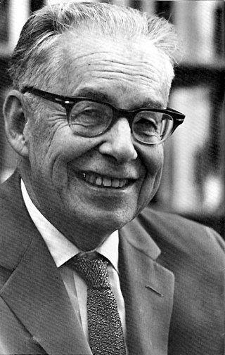
Charles Francis Richter was an American seismologist and physicist. He is the namesake and one of the creators of the Richter magnitude scale, which, until the development of the moment magnitude scale in 1979, was widely used to quantify the size of earthquakes. Inspired by Kiyoo Wadati's 1928 paper on shallow and deep earthquakes, Richter first used the scale in 1935 after developing it in collaboration with Beno Gutenberg; both worked at the California Institute of Technology.
The Saffir–Simpson hurricane wind scale (SSHWS) classifies hurricanes—which in the Western Hemisphere are tropical cyclones that exceed the intensities of tropical depressions and tropical storms—into five categories distinguished by the intensities of their sustained winds. This measuring system was formerly known as the Saffir–Simpson hurricane scale, or SSHS.

The Japan Meteorological Agency (JMA) Seismic Intensity Scale is a seismic intensity scale used in Japan to categorize the intensity of local ground shaking caused by earthquakes.
Peak ground acceleration (PGA) is equal to the maximum ground acceleration that occurred during earthquake shaking at a location. PGA is equal to the amplitude of the largest absolute acceleration recorded on an accelerogram at a site during a particular earthquake. Earthquake shaking generally occurs in all three directions. Therefore, PGA is often split into the horizontal and vertical components. Horizontal PGAs are generally larger than those in the vertical direction but this is not always true, especially close to large earthquakes. PGA is an important parameter for earthquake engineering, The design basis earthquake ground motion (DBEGM) is often defined in terms of PGA.

The ultraviolet index, or UV index, is an international standard measurement of the strength of the sunburn-producing ultraviolet (UV) radiation at a particular place and time. It is primarily used in daily and hourly forecasts aimed at the general public. The UV index is designed as an open-ended linear scale, directly proportional to the intensity of UV radiation, and adjusting for wavelength based on what causes human skin to sunburn. The purpose of the UV index is to help people effectively protect themselves from UV radiation, which has health benefits in moderation but in excess causes sunburn, skin aging, DNA damage, skin cancer, immunosuppression, and eye damage, such as cataracts.
The TORRO tornado intensity scale is a scale measuring tornado intensity between T0 and T11. It was proposed by Terence Meaden of the Tornado and Storm Research Organisation (TORRO), a meteorological organisation in the United Kingdom, as an extension of the Beaufort scale.

Tropical cyclones are ranked on one of five tropical cyclone intensity scales, according to their maximum sustained winds and which tropical cyclone basins they are located in. Only a few scales of classifications are used officially by the meteorological agencies monitoring the tropical cyclones, but other scales also exist, such as accumulated cyclone energy, the Power Dissipation Index, the Integrated Kinetic Energy Index, and the Hurricane Severity Index.
The Enhanced Fujita scale rates tornado intensity based on the severity of the damage they cause. It is used in some countries, including the United States, Canada, France, China, and Mongolia.
The Medvedev–Sponheuer–Karnik scale, also known as the MSK or MSK-64, is a macroseismic intensity scale used to evaluate the severity of ground shaking on the basis of observed effects in an area where an earthquake transpires.
Seismic magnitude scales are used to describe the overall strength or "size" of an earthquake. These are distinguished from seismic intensity scales that categorize the intensity or severity of ground shaking (quaking) caused by an earthquake at a given location. Magnitudes are usually determined from measurements of an earthquake's seismic waves as recorded on a seismogram. Magnitude scales vary based on what aspect of the seismic waves are measured and how they are measured. Different magnitude scales are necessary because of differences in earthquakes, the information available, and the purposes for which the magnitudes are used.

The 2007 Aysén Fjord earthquakes occurred in Aisén Fjord, Chile from January 22 – April 22. The biggest occurred at 1:53 p.m. on April 21 and reached a felt intensity of VII on the Mercalli intensity scale. On the moment magnitude scale, the earthquake reached a magnitude of 6.2. Ten people disappeared due to a tsunami caused by a landslide, according to ONEMI, but three bodies were found on April 22 by the Chilean Navy.
The San Marino Scale is a suggested scale for assessing risks associated with deliberate transmissions from Earth aimed to possible extraterrestrial intelligent life. The scale evaluates the significance of transmissions from Earth as a function of signal intensity and information content. The scale was suggested by Iván Almár at a conference in San Marino in 2005. The radio output of Jupiter, Saturn and Neptune is not considered in the model. The San Marino Scale was subsequently adopted by the SETI Permanent Study Group of the International Academy of Astronautics at its 2007 meeting in Hyderabad, India.
The maximum sustained wind associated with a tropical cyclone is a common indicator of the intensity of the storm. Within a mature tropical cyclone, it is found within the eyewall at a distance defined as the radius of maximum wind, or RMW. Unlike gusts, the value of these winds are determined via their sampling and averaging the sampled results over a period of time. Wind measuring has been standardized globally to reflect the winds at 10 metres (33 ft) above mean sea level, and the maximum sustained wind represents the highest average wind over either a one-minute (US) or ten-minute time span, anywhere within the tropical cyclone. Surface winds are highly variable due to friction between the atmosphere and the Earth's surface, as well as near hills and mountains over land.
The Richter scale, also called the Richter magnitude scale, Richter's magnitude scale, and the Gutenberg–Richter scale, is a measure of the strength of earthquakes, developed by Charles Francis Richter in collaboration with Beno Gutenberg, and presented in Richter's landmark 1935 paper, where he called it the "magnitude scale". This was later revised and renamed the local magnitude scale, denoted as ML or ML .
The 1965 Puget Sound earthquake occurred at 08:28 AM PDT on April 29 within the Puget Sound region of Washington state. It had a magnitude of 6.7 on the moment magnitude scale and a maximum perceived intensity of VIII (Severe) on the Mercalli intensity scale. It caused the deaths of seven people and about $12.5–28 million in damage. There were no recorded aftershocks.
The Environmental Seismic Intensity scale is a seismic scale used for measuring the intensity of an earthquake on the basis of the effects of the earthquake on the natural environment.
Seismic intensity scales categorize the intensity or severity of ground shaking (quaking) at a given location, such as resulting from an earthquake. They are distinguished from seismic magnitude scales, which measure the magnitude or overall strength of an earthquake, which may, or perhaps may not, cause perceptible shaking.