Hautes-Alpes is a department in the Provence-Alpes-Côte d'Azur region of Southeastern France. Located in and named after the Alps, it had a population of 141,107 in 2016, which makes it the third least populated French department. Its prefecture is Gap; its sole subprefecture is Briançon.
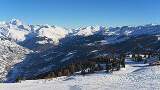
Savoie is a department in the Auvergne-Rhône-Alpes region of Southeastern France. Located in the French Alps, its prefecture is Chambéry. In 2017, Savoie had a population of 431,174.

Rhône-Alpes was an administrative region of France. Since 1 January 2016, it is part of the new region Auvergne-Rhône-Alpes. It is located on the eastern border of the country, towards the south. The region was named after the Rhône and the Alps mountain range. Its capital, Lyon, is the second-largest metropolitan area in France after Paris. Rhône-Alpes has the sixth-largest economy of any European region.

Lake Serre-Ponçon is a reservoir in the departments of Hautes-Alpes and Alpes-de-Haute-Provence, Provence-Alpes-Côte d'Azur region, in southeast France, one of the largest in Western Europe. The lake gathers the waters of the Durance and the Ubaye rivers, flowing down through the Hautes-Alpes and the Alpes du Sud to the Rhône. The waters are dammed by the Barrage de Serre-Ponçon, a 123-metre (404 ft) high earth core dam.

Gap is a commune in southeastern France, the capital and largest town of the Hautes-Alpes department. At a height of 750 m above sea level, it is France's highest prefecture.

The Verdon Gorge is a river canyon located in the Provence-Alpes-Côte d'Azur region of Southeastern France. It is about 25 km (15.5 mi) long and up to 700 metres (0.4 mi) deep. It was formed by the Verdon River, which is named for its turquoise-green colour, one of the location's distinguishing characteristics. In between the towns of Castellane and Moustiers-Sainte-Marie, the river has cut a ravine to a depth of 700 meters through the limestone mass. At the end of the canyon, the Verdon flows into the artificial Lake of Sainte-Croix.
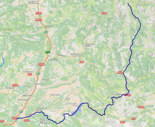
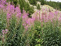
The Verdon is a 166.5-kilometre-long (103.5 mi) river in south-eastern France, left tributary of the Durance. Its drainage basin is 2,295 km2 (886 sq mi). Its source is at an elevation of 2,819 metres (9,249 ft), in the south-western Alps (Alpes-de-Haute-Provence), between the col d'Allos and the Trois Eveches mountain, south of Barcelonnette. It flows south-west through the following départements and towns:
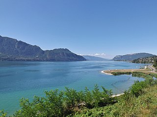
Lac du Bourget, also locally known as Lac Gris or Lac d'Aix, is a lake at the southernmost end of the Jura Mountains in the department of Savoie, France. It is the deepest lake located entirely within France, and either the largest or second largest after Lac de Grand-Lieu depending on season.

Mercantour National Park a French national park located in the Alpes-de-Haute-Provence and Alpes-Maritimes departments. Since it was created in 1979, the park has proven popular, with 800,000 visitors annually enjoying the 600 km of marked footpaths and visiting its villages.

The arrondissement of Castellane is an arrondissement of France in the Alpes-de-Haute-Provence department in the Provence-Alpes-Côte d'Azur region. It has 41 communes. Its population is 11,403 (2016), and its area is 1,718.1 km2 (663.4 sq mi).

Colmars or Colmars-les-Alpes is a commune in the Alpes-de-Haute-Provence department in southeastern France.
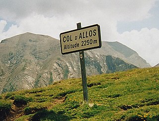
Col d'Allos is a high mountain pass in the Alps in the department of Alpes-de-Haute-Provence in France. It connects Barcelonnette in the Ubaye Valley and Colmars.

Col de la Cayolle is a high mountain pass in the French Alps at the border between the departments of Alpes-Maritimes and Alpes-de-Haute-Provence in France.

Col des Champs is a high mountain pass in the Alps at the border between the departments of Alpes-de-Haute-Provence and Alpes-Maritimes in France. It connects Saint-Martin-d'Entraunes and Colmars, joining the valleys of the Var River and the Verdon River.

Allos is a commune in the Alpes-de-Haute-Provence department in the Provence-Alpes-Côte d'Azur region of southeastern France.

Auzet is a commune in the Alpes-de-Haute-Provence department in the Provence-Alpes-Côte d'Azur region of south-eastern France.
The canton of Allos-Colmars is a former administrative division in southeastern France. It was disbanded following the French canton reorganisation which came into effect in March 2015. It consisted of 6 communes, which joined the canton of Castellane in 2015. It included the following communes:
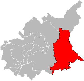
The canton of Castellane is an administrative division in southeastern France. At the French canton reorganisation which came into effect in March 2015, the canton was expanded from 7 to 32 communes. Its seat is in Castellane.

Alpes-de-Haute-Provence is a department in the Provence-Alpes-Côte d'Azur region of Southeastern France. Formerly part of the province of Provence, it had a population of 161,588 in 2016. Its main cities are Digne-les-Bains (prefecture), Manosque, Sisteron, Barcelonnette, Castellane and Forcalquier. Inhabitants of Alpes-de-Haute-Provence are called the Bas-Alpins or Bas-Alpines referring to the department of Basses-Alpes which was the former name of the department until 1970.
This page is based on this
Wikipedia article Text is available under the
CC BY-SA 4.0 license; additional terms may apply.
Images, videos and audio are available under their respective licenses.