
Evros is one of the regional units of Greece. It is part of the region of East Macedonia and Thrace. Its name is derived from the river Evros, which appears to have been a Thracian hydronym. Evros is the northernmost regional unit. It borders Turkey to the east, across the river Evros, and it borders Bulgaria to the north and the northwest.

Pythio, also referred to as Pythion (Πύθιον), is a village and community in the eastern part of Didymoteicho municipality, Evros regional unit, Greece. It is 16 km east of the centre of Didymoteicho, on the right bank of the river Evros, where it forms the border with Turkey. There is no road border crossing near Pythio
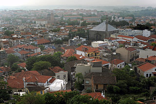
Didymoteicho is a town located on the eastern edge of the Evros regional unit of Eastern Macedonia and Thrace, in northeastern Greece. It is the seat of the municipality of the same name. The town sits on a plain and located south east of Svilengrad, south of Edirne, Turkey and Orestiada, west of Uzunköprü, Turkey, about 20 km north of Soufli and about 90 km north of Alexandroupoli. The municipality of Didymóteicho has a land area of 565.4 km² and a population of 16,060 inhabitants.
Amorio is a village in the municipal unit of Orfeas, northeastern Evros, Greece. It is situated at 2 km from the right bank of the river Evros, that forms the border with Turkey here. Amorio is 6 km northeast of Lavara, 7 km southwest of Didymoteicho and 21 km west of Uzunköprü (Turkey). The Greek National Road 51/E85 and the railway from Alexandroupoli to Didymoteicho pass through the village.
Isaakio is a village of Evros regional unit in Greece, part of the municipality Didymoteicho. It is located 5 kilometers east of Didymoteicho. Its population according to the 2021 census was 316.
Thourio is a village in the northern part of the Evros regional unit, in Greece. Thourio belongs to the municipality of Orestiada. It is located between Orestiada to the north and Didymoteicho to the south, about 4 km west of the river Evros, that forms the border with Turkey here. The nearest villages are Neo Cheimonio to the north and Sofiko to the south. Thourio is on the Greek National Road 51, and has a station on the Ormenio - Didymoteicho railway. Thourio lies 30 metres above sea level and is a lowland village with a fertile plain.
Ormenio is the northernmost place in all of Greece. It is part of the municipal unit of Trigono in the Evros regional unit of Thrace. It is situated near the right bank of the river Evros, which forms the border with Bulgaria here. On the other side of the Evros, 6 km to the north, lies the Bulgarian town Svilengrad. Nearby villages in Greece are Ptelea to its southeast and Petrota to its southwest.
Evgeniko is a village in the northeastern part of the Evros regional unit in Greece. It is located at the foot of low hills by the side of the river Erythropotamos. Evgeniko is part of the community of Mani within the municipality of Didymoteicho. It is 3.5 km south of Sitochori, 5 km northwest of Mani, 16 km northwest of Didymoteicho and 17 km southwest of Orestiada. Its population was recorded as 85 in the 2011 census.
Sitochori is a village in the northern part of the Evros regional unit, Greece. It is part of the municipality of Didymoteicho. Sitochori is about 20 km northwest of central Didymoteicho, and north of the river Erythropotamos.
Dikaia is a village in the northern part of the Evros regional unit in Greece. Dikaia was the seat of the former municipality of Trigono, and is part of the municipality Orestiada since 2011. In 2021, its population was 557 for the community, which includes the villages Dilofos, Krios and Palli. It is located on the right bank of the river Evros, where it forms the border with Bulgaria. It is about 15 km southeast of Svilengrad, Bulgaria, and 25 km west of Edirne, Turkey.
Ellinochori is a village in the northeastern part of the Evros regional unit in Greece. Ellinochori is part of the municipality of Didymoteicho. It is situated on the left bank of the river Erythropotamos, northwest of the centre of Didymoteicho. In 2021 its population was 1,060 for the community, including the villages Lagos and Thyrea.

The Erythropotamos or Luda reka is a river in southern Bulgaria and northeastern Greece. Its Turkish name was Kızıldelisu. Its source is near Mega Dereio. It flows into the Maritsa (Evros) near Didymoteicho.
Neo Cheimonio is a village in the municipality of Orestiada in the northern part of the Evros regional unit in Greece. It is 6 km south of the centre of Orestiada. Neo Cheimonio is situated on the Greek National Road 51, and has a station on the Ormenio - Didymoteicho railway. It is about 5 km west of the river Evros, that forms the border with Turkey here. The nearest village is Thourio to the south. It was annexed by Greece in 1920, prior it was ruled by the Ottomans.
Asvestades is a village in the municipality of Didymoteicho in the northern part of the Evros regional unit in Greece. It is 14 km west of the centre of Didymoteicho, in the hills south of the river Erythropotamos. It was known as "Kireççiler" during Ottoman rule. It was annexed to Greece in 1920. The nearest larger village is Kyani to its northeast.
Asimenio is a village in the municipality of Didymoteicho in the northern part of the Evros regional unit in Greece. It is about 8 km northeast of the centre of Didymoteicho. It is bypassed by the Greek National Road 51. The nearest larger villages are Sofiko to the north, and Pythio to the southeast.
Karoti is a village in the municipality of Didymoteicho in the northern part of the Evros regional unit, Greece. Its population was 181 in 2021. Karoti is 10 km (6.2 mi) northwest of central Didymoteicho. It was annexed to Greece as a result of the 1919 Treaty of Neuilly.
Kyani is a settlement in the municipality of Didymoteicho in the northern Evros regional unit, Greece. It is situated between farmlands in the plains on the right bank of the river Erythropotamos, at 40 m elevation. In 2021 its population was 411. It is 3 km northeast of Asvestades, 4 km southwest of Mani, and 10 km northwest of Didymoteicho.
Mani is a village and a community in the municipality of Didymoteicho in the Evros regional unit, Greece. It is situated near the left bank of the river Erythropotamos, 2 km west of Karoti, 4 km northeast of Kyani and 10 km northwest of Didymoteicho town centre. In 2021 its population was 364 for the community, which includes the villages Evgeniko and Sitaria. Its elevation is 55 m. The current town of Mani was founded by Maniot Greeks who fought under the King of Greece against the Republic of Turkey and Kemal Atatürk during the 1920s.
Poimeniko is a village and a community in the municipality of Didymoteicho in the eastcentral Evros regional unit, Greece. It is 2 km east of Sitochori, 3 km southwest of Ampelakia, 13 km southwest of Orestiada and 15 km northwest of Didymoteicho town centre. In 2021 its population was 225. Its elevation is 120 m. It is situated between farmlands, in an area with low hills.
