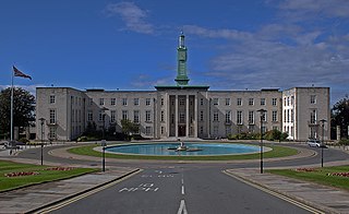
Walthamstow is a major district in the London Borough of Waltham Forest, located 7.5 miles (12.1 km) north-east of Charing Cross and immediately east of the Lee Valley Reservoir Chain and the Walthamstow Marshes. Historically an ancient parish in the county of Essex, its population increased as part of the suburban growth of London, becoming the Municipal Borough of Walthamstow in 1929. In 1965 the district merged with neighbouring Leyton and Chingford to form the new Borough of Waltham Forest, a component of the new Greater London area.

Grand River Transit (GRT) is the public transport operator for the Region of Waterloo, Ontario, Canada. It operates daily bus services in the region, primarily in the cities of Kitchener, Waterloo, and Cambridge, alongside the Ion rapid transit light rail system which began service on June 21, 2019.

Cheshunt is a town in the Borough of Broxbourne, Hertfordshire, lying entirely within the London Metropolitan Area and Greater London Urban Area. It is 12 miles (19 km) north of central London and has a population of around 44,000 according to the United Kingdom's 2001 Census.

The A24 is a major road in England that runs for 53.2 miles (85.6 km) from Clapham in south-west London to Worthing on the English Channel in West Sussex via the suburbs of south-west London, as well as through the counties of Surrey and West Sussex.

Sutton Bonington is a village and civil parish lying along the valley of the River Soar in the Borough of Rushcliffe, south west Nottinghamshire, England. The University of Nottingham has a 420 hectares (4.2 km2) site just to the north of the village: Sutton Bonington Campus.

Harrow Weald is the northernmost part of the town of Harrow in Greater London, England. It is formed from a leafy 1930s suburban development along with ancient woodland, and forms part of the London Borough of Harrow.

Old Swan is an eastern neighbourhood of Liverpool, Merseyside, England, bordered by Knotty Ash, Stoneycroft, Broadgreen, Fairfield and Wavertree. At the 2011 Census, the population was 16,461.

Grove Park is a district of South East London, England within the London Borough of Lewisham. It is located north east of Bromley and south east of Lewisham.
Merseytravel is the Passenger transport executive and Strategic Transport Advisor for the Liverpool City Region. Responsible for the coordination of public transport in Merseyside, North West England. Merseytravel was established on 1 December 1969 as the Merseyside Passenger Transport Executive. From 1 April 2014 Merseytravel expanded its area of operation from the metropolitan county of Merseyside to also include the Borough of Halton.

Chesterfield railway station serves the town of Chesterfield in Derbyshire, England. It lies on the Midland Main Line. Four tracks pass through the station which has three platforms. It is currently operated by East Midlands Railway.
St Helens Junction railway station is a railway station serving St Helens, Merseyside, England. It is in Sutton, 3 miles south-west of St Helens town centre. The station is on the electrified northern route of the Liverpool to Manchester Line, 12 miles (19 km) east of Liverpool Lime Street. The station and all trains calling there are presently operated by Northern Trains.

The A217 is a road in London and Surrey in England. It runs north/south. It runs from Kings Road in Fulham, London, crosses the Thames at Wandsworth Bridge, then passes through Wandsworth, Earlsfield, Summerstown, Tooting, Mitcham, Rosehill and Sutton Common in Sutton, then Cheam. Then, widened as a dual carriageway, comes Belmont, a suburban district built on a slope rising southward. On the North Downs in Surrey the road then skirts past Banstead and through its late 19th century offspring villages particularly Burgh Heath and Kingswood, Surrey. It then crosses the M25 motorway at Junction 8, then, returning to single carriageways, passes through the castle town of Reigate. It then cuts through the green buffer farmland of two rural villages and terminates at the road network at Gatwick Airport's northern perimeter.

Ashtown is a small suburb of Dublin, Ireland. It is also a townland in the civil parish of Castleknock and falls largely into the postal districts of Dublin 15, with some addresses falling into the Dublin 7 postal district.

The A6 road in Northern Ireland runs for 71.4 miles (114.9km) from Belfast to Derry, via County Antrim and County Londonderry. From Belfast to Randalstown the route has been superseded by a motorway. Mostly single carriageway, there are sections of dual carriageway in Antrim town centre and from Randalstown to Toome, including the Toome bypass. In urban and suburban districts of Belfast and Derry the route is single carriageway with 4 lanes. In rural parts, there are numerous climbing lanes along the route. The A6 is one of Northern Ireland's most important arterial routes, as the road runs between its two largest cities and urban areas. Between Randalstown and Derry the road forms part of European route E16.

The A202 is a primary A road in London. It runs from New Cross Gate to London Victoria station. A section of the route forms a part of the London Inner Ring Road between Vauxhall and Victoria, known as Vauxhall Bridge Road.

The A2212 road is a 4-digit, non-primary A road in southeast London, England; it is 5.7 km (3.5 mi) long and runs in a north to south direction from Lee Green, to Bromley passing through Grove Park, Downham, Plaistow and Sundridge. Bromley is the only one of these places which is a primary destination.
Mount Joy is a community located in north part of Markham, Ontario, Canada near Highway 48 and 16th Avenue and part of the former Village of Markham.

Ribbleton is a suburb and ward of the city of Preston, Lancashire, England. It is located to the east of the city centre, between the A59 New Hall Lane and the B6243 Longridge Road. The M6 motorway also runs through the area. The ward had a population of 7,351 recorded in the 2001 census increasing to 8,548 at the 2011 Census.

The Isle of Wight Coastal Path is a circular long-distance footpath of 70 miles (113 km) around the Isle of Wight, UK. It follows public footpaths and minor lanes, with some sections along roads.

Rickleton is an area of Washington, Tyne and Wear, England. It is located on the south side of Washington Town and borders Harraton village, Birtley and County Durham. The village centre includes a Londis supermarket, a general store, a hairdressing salon, Finewood Chinese takeaway and a bus link, which has buses linking to other areas of Washington and County Durham. A family pub, The Woodlands, Washington Cricket club, two doctors surgeries and a chemists can also be found here. There is also a large field with a small children's playing area located just of the bus route through Rickleton.
