The Laguna Canyon Project (1980-2010), a long-term environmental art project, used a variety of tactics and techniques to focus attention on the bucolic Laguna Canyon Road, one of the last undeveloped passages to the Pacific Ocean.[1] The project, created by photographic artists Jerry Burchfield and Mark Chamberlain, was a response to explosive growth in south Orange County and especially to the threats of development within their hometown of Laguna Beach, California. What began as a 10-year project lasted for three decades.
Environmental art is a range of artistic practices encompassing both historical approaches to nature in art and more recent ecological and politically motivated types of works. Environmental art has evolved away from formal concerns, worked out with earth as a sculptural material, towards a deeper relationship to systems, processes and phenomena in relationship to social concerns. Integrated social and ecological approaches developed as an ethical, restorative stance emerged in the 1990s. Over the past ten years environmental art has become a focal point of exhibitions around the world as the social and cultural aspects of climate change come to the forefront.
The Pacific Ocean is the largest and deepest of Earth's oceanic divisions. It extends from the Arctic Ocean in the north to the Southern Ocean in the south and is bounded by Asia and Australia in the west and the Americas in the east.
Laguna Beach is a seaside resort city located in southern Orange County, California, in the United States. It is known for a mild year-round climate, scenic coves, environmental preservation, and an artist community. The population in the 2010 census was 22,723. As per population estimate in July 2017 the total population of Laguna Beach city was 23,174.
Over its first 10 years, the project drew an ever-expanding number of supporters. It empowered local artists and concerned citizens to get actively involved in the fate of the Canyon, while informing the greater Orange County, California about the environmental issues.
Orange County is located in the Los Angeles metropolitan area in the U.S. state of California. As of the 2010 census, the population was 3,010,232, making it the third-most populous county in California, the sixth-most populous in the United States, and more populous than 21 U.S. states. Its county seat is Santa Ana. It is the second most densely populated county in the state, behind San Francisco County. The county's four largest cities by population, Anaheim, Santa Ana, Irvine, and Huntington Beach, each have a population exceeding 200,000. Several of Orange County's cities are on the Pacific Ocean western coast, including Huntington Beach, Newport Beach, Laguna Beach, Dana Point, and San Clemente.
The project reached its high point in 1989 when, in celebration of the Orange County Centennial and the Sesquicentennial of the discovery of photography, the art partners erected a giant photographic mural in a critical location of the Canyon. They built this 636-foot-long mural, entitled The Tell,[2] in the Sycamore Hills area of Laguna Coast Wilderness Park.[3]
Laguna Coast Wilderness Park is a 7,000-acre (2,800 ha) wilderness area in the San Joaquin Hills surrounding Laguna Beach, California. This park features coastal canyons, ridgeline views and the only natural lakes in Orange County, California. Trails are maintained for hiking and mountain biking with a wide range of difficulty, from beginner to expert. Most trails gain in height, reaching a maximum of 1,000 feet (300 m) in elevation. Several trails lead to downtown Laguna Beach.
As this public installation was located on Laguna Canyon Road—the main artery into Laguna Beach—and across this road from a proposed massive housing development, it became the focal point and catalyst for massive public demonstrations, protesting that project.
The Tell ultimately served a crucial role in the preservation of this region.
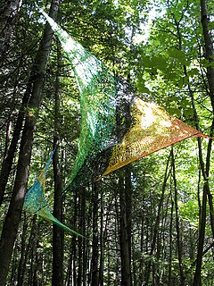
The Green Man at The Tell
From October 18, 2015 through January 17, 2016, an exhibition on the Laguna Canyon Project, titled "The Canyon Project: Artivism," was held at Laguna Art Museum, Laguna Beach, California.[4][5]
The book, "The Laguna Canyon Project: Refining Artivism," was published in 2018 by Laguna Wilderness Press.[6]
Artivism is a portmanteau word combining art and activism.
Genesis of Laguna Canyon Project
Throat of The Tell Photomural
Jerry Burchfield and Mark Chamberlain (photographer)s opened BC Space, a combination photo lab/studio/ gallery in 1973, to provide photographic services for galleries, museums and artists.[7] During their many hours working together, they often discussed what they could do to protect the Laguna Canyon. They ultimately agreed upon a course of action and in the spring of 1980 commenced the "Laguna Canyon Project: The Continuous Document," their long-term environmental art project. The immediate goal was to preserve the canyon in the tradition of documentary photography, while challenging the community to preserve it in reality.[8]
For Phase I of the project, with a handful of volunteers, they photographed both sides of the Laguna Canyon Road. The resulting 646 frames per side were printed into twin color prints, depicting their passage down the “last nine miles of the westward migration.”
Evolution to performance art
Soon after, they repeated the survey, but this time at night, and dubbed it Phase III, "Nightlight Documentation.” Publicity from these ventures was beginning to generate responses from people offering to help with future phases. The partners also realized that the project's phases were turning into performance art, in addition to documentation.
The next phase was to “paint the canyon with light.” This phase took two years of planning, required more people, expensive equipment, and permits from multiple level governmental agencies. The pair lobbied regional environmental groups, the art community, and local public officials for permission and support.
In September 1983, Chamberlain and Burchfield executed Phase V, "Primary Light Documentation,” requiring 65 designated participants (plus backup) obtained 13 vehicles and a 30,000-watt generator, towed by a 40-foot flatbed truck. They moved this entire caravan down Laguna Canyon Road from 6PM to 6AM, while escorted by three different police agencies and Caltrans officials. The resulting images were printed onto a single print 3.5 inches wide by 516 feet long, depicting the entire length of the Northeast side of the road in kaleidoscopic color.
The Tell photographic mural
Coyote Door at The Tell
By 1987, core samples were being taken for Southern California's first toll road, which would bisect Laguna Canyon, and maps were being drawn for the 3,200-unit Laguna Laurel housing development, which the road would serve. Construction for both was scheduled to begin in 1989. In response to these expected developments, Burchfield and Chamberlain began extensive lobbying to execute their next phase, which was to build a giant photographic mural in the canyon, directly in the path of the toll road, and across the highway from the proposed new city.
On May 1, 1989, after three years of planning and months of fundraising, the art partners, along with a growing army of environmentalists, began constructing an outdoor photographic mural called The Tell. Since 1989 was the Centennial of Orange County, CA and the 150th anniversary of the discovery of photography, they decided that the project would be composed of photographs contributed by local residents and by people from all over the country. The installation would express concern, artistically, about the survival of the historic Laguna Canyon. When completed, Phase VIII, The Tell was a contemporary mound of artifacts and an environmental artwork, which reflected the community's past and looked to its future.[9][10][11][12]
The name "Tell" comes from the archeological term for a mound of artifacts from prior civilizations, buried over by natural elements. This Tell was built (rather than unearthed) as a small mountain composed of thousands of photographs, reflective of the lives of the people who donated images. It grew to 636-feet long and ranged from 36-feet high, dwindling down to the ground, as it undulated across the landscape and dove back into the hillside. The sculptural character of the artwork resembled the voluptuous nature of the surrounding canyons, with echoes of a female figure in its shape. It had a stylized Easter Island head as its physical and philosophical foundation.
The pictures, glued onto the wooden framework, were woven together like pixels in a pointillist painting by density, color, content and type of material. They told numerous stories of man, woman and the land. These symbols were positioned by story lines on the chakra points of the larger body of the mural.
Visitors to The Tell in the early spring saw vibrant, colorful images of themselves, their families and friends as part of the very large art work. Later in the summer and fall, as the canyon was transformed into desert colors, these photos and stories faded to become a part of the background fabric of a larger story of man's relationship with spaceship Earth.
During the months of construction, the mural became the focal point and catalyst for numerous events and demonstrations. Some were planned and many happened spontaneously.
The Tell dedication
Mark Turnbull at the Tell
More than 2,500 people attended the August 19 dedication of The Tell, erected in Laguna's Sycamore Hills area, including scores of environmental groups from all across the county. The installation also attracted media attention, including articles in the Los Angeles Times,[13]Orange County Register and Life.
When The Tell was dismantled,[14] it was coded and stored with the hope that it would be installed in a museum. But it was so politically charged that no art organization would assist in its preservation. Lacking safe storage, most of the photographic mural burned in the Laguna Beach fire of 1993.
Unlike an actual Tell, the structure was carefully removed to leave little evidence in the land it was attempting to save. All that remains at the site today are 88 barely visible postholes filled with pea gravel rhythmically spaced on the hillside for future explorers to discover.
From October 18, 2015 through January 17, 2016, an exhibition on the Project, titled "The Canyon Project: Artivism," including pieces of "The Tell," was held at Laguna Art Museum, Laguna Beach, California.[15]
The Walk
The Walk to Save Laguna Canyon
On November 11, 1989, The Tell became the destination for an estimated 8,000 to 11,000 people who marched there from downtown Laguna for the "Walk to Save Laguna Canyon." These participants then held a demonstration protesting the proposed 3,200 unit Laguna Laurel housing development, which was scheduled to be built across the road from The Tell site.
Largely as a consequence of months of community involvement in the building of the mural, and of this dramatic public display, the Irvine Company negotiated with the cities of Irvine and Laguna Beach to release that land for public acquisition. In 1990, Laguna residents voted overwhelmingly to tax themselves to purchase the land to keep it as open space.[16]
Laguna Beach environment
Laguna Coast Wilderness Park entrance
The most traveled route into town is the nine-mile Laguna Canyon Road within the 7,000-acre (2,800ha) Laguna Coast Wilderness Park, which has some of the last remaining undeveloped coastal canyons in Southern California. The park is dominated by coastal sage scrub, cactus and native grasses. Over 40 endangered and sensitive species call Laguna Coast home, including California gnatcatcher, cactus wren, and the endemic Laguna Beach dudleya. Drive further down the road toward the Pacific Ocean, and you pass the campus of Laguna College of Art and Design, artists’ studios, numerous public art pieces, and three world famous summer art festivals.
Laguna’s artistic legacy stretches back to the late 19th and early 20th centuries when people from across this country and Europe, many steeped in French Impressionism, moved to this area. Artists, including Frank Cuprien, Joseph Kleitsch and William Wendt, settled here, formed an art colony and used Canyon landscapes as subjects of their paintings. They employed the broad-brush strokes and pure, bright colors of their earlier French counterparts to capture the canyons; their artistic style came to be called California Impressionism. These paintings, displayed all over Laguna today, have transcendent qualities, expressing reverence for the beauty of the land. As you drive, hike or bike through Laguna Canyon, you can view vistas evocative of these paintings.
Additional phases of Laguna Canyon Project
Irvine Man at The Tell
Phase IX: The Daylight Document II, April 1990
Phase X: The Nightlight Document II, November 1990
Phase XI: “Tales of The Tell” Exhibition, BC Space, Fall 1990
Phase XII: “The Witness Box,” July 26, 1994
Phase XIII: Into Grace Under Fire, December 21, 1994
Phase XIV: The Daylight Document III, April 2000
Phase XV' The Nightlight Document III, November 2000
Phase XVI: The Daylight Document IV, Final Phase, June 21, 2010. A dozen participants documented the nine-mile Laguna Canyon Road.
Related Research Articles
Laguna Niguel is a suburban city in Orange County, California in the United States. The name Laguna Niguel is derived from the words "Laguna" and "Niguili". As of the 2010 census, the population was 62,979. Laguna Niguel is located in the San Joaquin Hills in the southeastern corner of Orange County, close to the Pacific Ocean, and borders the cities of Aliso Viejo, Dana Point, Laguna Beach, Laguna Hills, Mission Viejo, and San Juan Capistrano.
State Route 91 is a major east–west freeway located entirely within Southern California and serving several regions of the Greater Los Angeles urban area. Specifically, it currently runs from Vermont Avenue in Gardena, just west of the junction with the Harbor Freeway, east to Riverside at the junction with the Pomona, and Moreno Valley freeways.
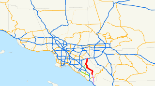
State Route 133 is a state highway in the U.S. state of California. It connects SR 1 in Laguna Beach through the San Joaquin Hills with several freeways in Irvine, ending at the SR 241 toll road in the latter city. It is built as an expressway from SR 73 to Laguna Canyon Road, and past this, SR 133 is a freeway to I-5, and a tollway to SR 241 near the Santa Ana Mountains.
State Route 241 is a tollway located entirely in Orange County, California, in the Greater Los Angeles urban area. For its entire length, Route 241 is a toll road. Its northern half is part of the Eastern Transportation Corridor while its southern half is part of the Foothill Transportation Corridor. The highway currently runs from Ladera Ranch to Yorba Linda. State Route 241 connects with State Route 133, State Route 261, and State Route 91.
Robert Wyland, commonly known as Wyland, is an American artist best known for his 100 Whaling Walls, large outdoor murals featuring images of life-size whales, and other sea life.
Josh Agle is an American artist, better known by the nickname Shag.
Edgar Alwin Payne was an American Western landscape painter and muralist.
The Laguna Art Museum (LAM) is a museum located in Laguna Beach, California, on Pacific Coast Highway. LAM exclusively features California art and is the oldest cultural institution in the area. It has been known as the Laguna Beach Art Association, as well as the Laguna Beach Museum of Art.
The San Joaquin Hills are a low mountain range of the Peninsular Ranges System, located in coastal Orange County, California.
Aliso Creek is a 19.8-mile (31.9 km)-long, mostly urban stream in south Orange County, California. Originating in the Cleveland National Forest in the Santa Ana Mountains, it flows generally southwest and empties into the Pacific Ocean at Laguna Beach. The creek's watershed drains 34.9 square miles (90 km2), and it is joined by seven main tributaries. As of 2018, the watershed had a population of 144,000 divided among seven incorporated cities.
Laguna Canyon is the name of a canyon that cuts through the San Joaquin Hills in southern Orange County, California, in the United States, directly south of the city of Irvine. The canyon runs from northeast to southwest, and is drained on the north side by tributaries of San Diego Creek and on the south by Laguna Canyon Creek. It is deeper and more rugged on the southwestern end near Laguna Beach.
Sulphur Creek is a 4.5-mile (7.2 km) tributary of Aliso Creek in Orange County in the U.S. state of California. The creek drains about 6 square miles (16 km2) of residential communities and parks in the southern San Joaquin Hills.
Douglas McCulloh is an American photographer notable for conceptual photographic projects based on “systematic randomness” and chance operations. McCulloh’s work is “an extension of the traditions of street photography, social documentary photography, oral history and Surrealist chance operations,” states photo historian Jonathan Green. “As such, it is grounded in some of the century’s most powerful conceptual currents.” McCulloh is one of six photographers who in 2006 transformed an F-18 jet hangar into the world’s largest camera to make the world’s largest photograph. McCulloh also curates exhibitions, most notably Sight Unseen: International Photography by Blind Artists, the first major museum exhibition of work by blind photographers. McCulloh, under the nom-de-plume “Quoteman,” has also collected and posted online thousands of quotations about photography.
The Endangered Planet Foundation (EPF) is a 501(c)(3) non-profit organization founded in the United States whose mission is to raise awareness of pro-environmental causes via dialog and the arts, recognizing that advances in technology can provide many of the answers that will lead to a sustainable future.
Mark Phineas Chamberlain was an American photographic/environmental/installation artist, gallery owner and curator. He was born and raised in Dubuque, Iowa, received his BA in Political Science in 1965, and Masters in Operations Research in 1967, from the University of Iowa. Chamberlain was drafted into the U.S. Army in 1967 and stationed in Korea during the American War in Vietnam. On discharge from the army, he changed his previous career course to become a photographic artist. He explains, "While stationed overseas, I picked up a camera to maintain my sanity and provide a creative outlet. I also took classes in the Korean language and history and found a photography mentor in the military crafts program. Returning home, I had a growing desire to find an outlet for this newfound passion." In 1969, Chamberlain moved to Southern California, aspiring to open a photographic art gallery.
The Sawdust Art Festival, also known as The Sawdust, is an art festival held annually from late June through August in Laguna Beach, California. The festival features handicrafts as well as traditional fine art. It is non-juried, but exhibitors are required to be Laguna Beach residents. About 200,000 visitors attend each year. The Sawdust also hosts an annual Winter Fantasy art fair in mid-November through December, which is open to non-resident exhibitors.
Robert Ray Hedden is an American writer and film director.
This page is based on this Wikipedia article Text is available under the CC BY-SA 4.0 license; additional terms may apply. Images, videos and audio are available under their respective licenses.