Laguna Coast Wilderness Park

Last updated

Laguna Coast Wilderness Park
Laguna Coast Wilderness Park.jpg
Boomer Ridge Trail, Laguna Coast Wilderness Park
USA California location map.svg
Red pog.svg
Location San Joaquin Hills, Orange County, California
Nearest city Laguna Beach, California
Coordinates 33°34′27″N117°46′33″W / 33.5743°N 117.7757°W / 33.5743; -117.7757 Coordinates: 33°34′27″N117°46′33″W / 33.5743°N 117.7757°W / 33.5743; -117.7757
Area7,000 acres (2,800 ha)
Governing bodyOrange County Parks
www.ocparks.com/lagunacoast/

Laguna Coast Wilderness Park [1] is a 7,000-acre (2,800 ha) wilderness area in the San Joaquin Hills surrounding Laguna Beach, California. This park features coastal canyons, ridgeline views and the only natural lakes in Orange County, California. Trails are maintained for hiking and mountain biking with a wide range of difficulty, from beginner to expert. Most trails gain in height, reaching a maximum of 1,000 feet (300 m) in elevation. Several trails lead to downtown Laguna Beach.

San Joaquin Hills hill range in California

The San Joaquin Hills are a low mountain range of the Peninsular Ranges System, located in coastal Orange County, California.

Laguna Beach, California City in California, United States

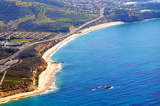
Laguna Beach is a seaside resort city located in southern Orange County, California, in the United States. It is known for a mild year-round climate, scenic coves, environmental preservation, and an artist community. The population in the 2010 census was 22,723. As per population estimate in July 2017 the total population of Laguna Beach city was 23,174.

Orange County, California County in California, United States

Orange County is located in the Los Angeles metropolitan area in the U.S. state of California. As of the 2010 census, the population was 3,010,232, making it the third-most populous county in California, the sixth-most populous in the United States, and more populous than 21 U.S. states. Its county seat is Santa Ana. It is the second most densely populated county in the state, behind San Francisco County. The county's four largest cities by population, Anaheim, Santa Ana, Irvine, and Huntington Beach, each have a population exceeding 200,000. Several of Orange County's cities are on the Pacific Ocean western coast, including Huntington Beach, Newport Beach, Laguna Beach, Dana Point, and San Clemente.

Contents

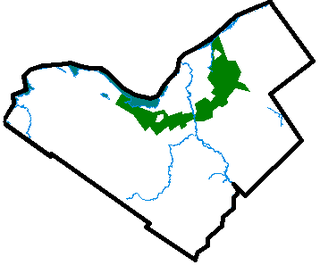
Laguna Coast Wilderness Park has some of the last remaining undeveloped coastal canyons in Southern California. The park is dominated by coastal sage scrub, cactus and native grasses. Over 40 endangered and sensitive species call Laguna Coast home including California gnatcatcher, cactus wren and the endemic Dudleya stolonifera . Both Laguna Coast, Aliso and Wood Canyons Wilderness Park are also home to mule deer, long-tailed weasel, healthy bobcat populations, and raptors like red-tailed hawk and the ground-nesting northern harrier.

Coastal sage scrub

Coastal sage scrub, also known as coastal scrub, CSS, or soft chaparral, is a low scrubland plant community of the California coastal sage and chaparral subecoregion, found in coastal California and northwestern coastal Baja California. It is within the California chaparral and woodlands ecoregion, of the Mediterranean forests, woodlands, and scrub biome.

California gnatcatcher species of bird

The California gnatcatcher is a small 10.8 cm (4.3 in) long insectivorous bird which frequents dense coastal sage scrub growth. This species was recently split from the similar black-tailed gnatcatcher of the Sonoran and Chihuahuan deserts. This bird is often solitary, but joins with other birds in winter flocks.

Cactus wren Desert adapted bird found in the southwest of the United States and in northern Mexico.

The cactus wren is a species of wren that is endemic to parts of the southwestern United States, as well as northern and central Mexico. There are eight generally recognized subspecies, and the nominate species has a brown crown, with notable white eyebrows that stretch to the nape of the neck. The wings and feathers are brown, but are marked with black and white spots. The tail, as well as certain flight feathers, are also alternatively barred in black and white. The chest is whiter, while the underparts are cinnamon-buff colored. Its song is harsh and raspy and has been described by ornitholgists like a car engine that will not start.

South Coast Wilderness Area

Laguna Coast Wilderness Park is part of the contiguous approximately 20,000-acre (8,100 ha) South Coast Wilderness Area in southern Orange County, California. It stretches from Newport Beach to Laguna Niguel, and from Irvine to the Pacific Ocean.

The genesis of this designated wilderness area occurred in 1960 when bookstore owner James Dilley began advocating for a Laguna Beach greenbelt. [2] Dilley's dream ultimately required the commitment of thousands of people, more than $65 million and decades to complete.

In 1990, inspired by a quartet of Laguna-based non-profits and by Laguna Beach, Irvine and Laguna Woods, the County of Orange, the State of California and the Irvine Company, voters approved a $20 million bond to purchase Laguna Canyon, to prevent development there and to keep it as an open space green belt forever.

Irvine Company Real Estate company

The Irvine Company is an American private company focused on real estate development. It is headquartered in Newport Beach, California, with a large portion of its operations centered in and around Irvine, California, a planned city of 250,000 people mainly designed by the Irvine Company. The company was founded by the Irvine family and is currently wholly owned by Donald Bren. Since the company is private, its financials are not released to the public. However, Donald Bren is the most wealthy real estate developer in the United States, valued at $15.2 billion.

Green belt largely undeveloped, wild, or agricultural land surrounding urban areas

A green belt or greenbelt is a policy and land use zone designation used in land use planning to retain areas of largely undeveloped, wild, or agricultural land surrounding or neighbouring urban areas. Similar concepts are greenways or green wedges which have a linear character and may run through an urban area instead of around it. In essence, a green belt is an invisible line designating a border around a certain area, preventing development of the area and allowing wildlife to return and be established.

Today, the South Coast Wilderness area offers visitors access to Orange County’s only natural lakes, a thriving wildlife community, nature centers, interpretive programs, and recreational activities, from hiking and birding to mountain biking.[ citation needed ]

Laguna Coast Wilderness Park entrance Laguna Coast Wilderness Park entrance.jpg
Laguna Coast Wilderness Park entrance

The South Coast Wilderness open space includes:

Laguna Greenbelt

Laguna Coast Wilderness Park Biking, Laguna Coast Wilderness Park.jpg
Laguna Coast Wilderness Park

Laguna Greenbelt, Inc. is a grassroots organization, founded in 1968 to preserve and protect the environment in and around Laguna Beach and Orange County. This non-profit works for the benefit of the general public informing, advocating and educating concerned citizens. With James Dilley [3] as its founder, Laguna Greenbelt secures open space for the residents of Orange County and beyond. The Greenbelt believes, "that open space and wilderness areas along with wildlife habitat preservation are critical to the long-term health and well being of residents of southern California…We fought to preserve Laguna Canyon, Aliso and Woods Canyons and, the large swath of coastal hills known as the San Joaquin Hills. Much of our history has revolved around informing citizens, decision makers and stakeholders about the many benefits of open space preservation and protection…This work continues today with our initiative on the Irvine Regional Wildlife Corridor, an important wildlife habitat connection between the Laguna Greenbelt/South Coast Wilderness area and the Cleveland National Forest." Laguna Greenbelt also helped facilitate the formation of the Laguna Canyon Foundation.

Laguna Canyon Foundation

Final Days of The Tell 1990 9.Final Days of The Tell 1990.jpg
Final Days of The Tell 1990

Following the historic environmental events of 1989, including the creation of The Tell [4] [5] photographic mural, as part of the Laguna Canyon Project, and the subsequent "Walk to Save Laguna Canyon" that culminated at this outdoor public installation, [6] a bond measure was passed in 1990 by Laguna Beach voters; after which the Laguna Canyon Foundation [7] was formed to manage preservation of Laguna Canyon. The Canyon Foundation soon facilitated the purchase of additional sections of open space that had been slated for development, and in 1993, established Laguna Coast Wilderness Park. [8] In 2014, Laguna native Hallie Jones was named executive director of the Laguna Canyon Foundation. [8]

Today, more than 200 Laguna Canyon Foundation volunteers help Orange County Parks manage these very special coastal canyons. The James and Rosemary Nix Nature Center on Laguna Canyon Road in the Wilderness Park contributes to this effort by featuring exhibits, educational programs, guided hikes and other activities. [8] In 2015, it was featured, along with other organizations, in Laguna Beach Eco Heroes, a 30-minute documentary by The My Hero Project. The efforts of the Crystal Cove Alliance, ECO-Warrior Foundation|ECO Warrior, Laguna Bluebelt, Nancy Caruso, One World One Ocean, Pacific Marine Mammal Center, Wyland, and Zero Trash Laguna were also highlighted in the documentary. [9]

Aliso & Wood Canyons Aliso-Wood Canyons.jpg
Aliso & Wood Canyons

Related Research Articles

Aliso Viejo, California City in California, United States

Aliso Viejo is a city in the San Joaquin Hills of southern Orange County, California. It had a population of 47,823 as of the 2010 census, up from 40,166 as of the 2000 census. It became Orange County's 34th city on July 1, 2001, the only city in Orange County to be incorporated since 2000. It is bordered by the cities of Laguna Beach on the west and southwest, Laguna Hills on the east, Laguna Niguel on the southeast, and Laguna Woods on the north.

Laguna Niguel, California City in California, United States

Laguna Niguel is a suburban city in Orange County, California in the United States. The name Laguna Niguel is derived from the words "Laguna" and "Niguili". As of the 2010 census, the population was 62,979. Laguna Niguel is located in the San Joaquin Hills in the southeastern corner of Orange County, close to the Pacific Ocean, and borders the cities of Aliso Viejo, Dana Point, Laguna Beach, Laguna Hills, Mission Viejo, and San Juan Capistrano.

Crystal Cove State Park state park on the coast of California, USA

Crystal Cove State Park is a state park of California, United States, encompassing 3.2 miles (5.1 km) of Pacific coastline, inland chaparral canyons, and the Crystal Cove Historic District of beach houses. The park is located in Newport Beach. Crystal Cove is a stretch of coastal cliffs and a beachfront cove situated between the Pacific Coast Highway and the Pacific Ocean just north of Laguna Beach. The 3,936-acre (1,593 ha) park was established in 1979. The entire park hosts a total of 3 miles of beaches and tide pools, a 1,400 acre marine Conservation Area as well as underwater park, 400 acres of bluffs, and 2,400 acres of canyons.

Area code 949

Area code 949 is a California telephone area code that was split from area code 714 on April 18, 1998. It is an area mostly within southern Orange County. It also includes a small adjacent area of northwest San Diego County, specifically parts of Marine Corps Base Camp Pendleton and San Onofre State Park. Costa Mesa is shared between the 949 and 714 area codes, being split at Wilson Street and along Newport Boulevard. A very small portion of Irvine is also in the 714 area code, from the north side of Culver Drive at the I-5 to Jamboree Road in the Marketplace, in the neighborhood of Northpark Irvine.

Californias 48th congressional district American political district

California's 48th congressional district is a congressional district in the U.S. state of California based in Orange County in Southern California. It is currently represented by Harley Rouda.

Aliso Creek (Orange County) river in the United States of America

Aliso Creek is a 19.8-mile (31.9 km)-long, mostly urban stream in south Orange County, California. Originating in the Cleveland National Forest in the Santa Ana Mountains, it flows generally southwest and empties into the Pacific Ocean at Laguna Beach. The creek's watershed drains 34.9 square miles (90 km2), and it is joined by seven main tributaries. As of 2018, the watershed had a population of 144,000 divided among seven incorporated cities.

Top of the World (park) park in California, United States of America

Top of the World is a community park located in Laguna Beach, California. The park's official name is Alta Laguna Park, but it is referred to as Top of the World. It is located at the north end of Alta Laguna Blvd.

Aliso and Wood Canyons Wilderness Park

Aliso and Wood Canyons Wilderness Park is a major regional park in the San Joaquin Hills of Orange County, California in the United States. Comprising 4,500 acres (1,800 ha) of rugged coastal canyons, open grassland, and riparian woodland, the park borders the suburban cities of Aliso Viejo, Dana Point, Laguna Beach, Laguna Hills and Laguna Niguel.

Salt Creek (Orange County)

Salt Creek is a small coastal stream in southern Orange County in the U.S. state of California. The 4-mile (6.4 km) creek drains 6.1 square miles (16 km2) in parts of the cities of Laguna Niguel, Dana Point, and San Juan Capistrano. The mostly channelized creek has no named surface tributaries. The creek begins in the central portion of the city of Laguna Niguel and flows west and south through a narrow canyon referred to as the Salt Creek Corridor, which is mostly inside a long and narrow regional park. It then flows into the Monarch Beach Golf Course in the city of Dana Point and enters a subsurface storm channel which carries it to its discharge point at Salt Creek County Beach.

Wood Canyon Creek river in the United States of America

Wood Canyon Creek is a 2.8 mi (4.5 km) perennial stream in Aliso and Wood Canyons Wilderness Park, Orange County, California. A tributary of Aliso Creek, it drains a deep undeveloped valley to the west of Aliso Viejo.

Laguna Canyon landform

Laguna Canyon is the name of a canyon that cuts through the San Joaquin Hills in southern Orange County, California, in the United States, directly south of the city of Irvine. The canyon runs from northeast to southwest, and is drained on the north side by tributaries of San Diego Creek and on the south by Laguna Canyon Creek. It is deeper and more rugged on the southwestern end near Laguna Beach.

Sulphur Creek (California)

Sulphur Creek is a 4.5-mile (7.2 km) tributary of Aliso Creek in Orange County in the U.S. state of California. The creek drains about 6 square miles (16 km2) of residential communities and parks in the southern San Joaquin Hills.

Aliso Canyon canyon located in Laguna Beach California

Aliso Canyon is a 6.5-mile (10.5 km) canyon located in Orange County, California in the United States. The canyon is a water gap across the San Joaquin Hills carved out by Aliso Creek, possibly as recently as the last Ice Age. Located in a semi-arid climate, it supports a variety of plant communities – mainly chaparral and coastal sage scrub – and native animals, some endangered.

Bommer Canyon

Bommer Canyon is an open space preserve in southern Irvine, California featuring hiking and biking trails as well as private event areas. The canyon is part of the Irvine Ranch, which itself is a National Natural Landmark, the first California Natural Landmark, and part of the City of Irvine Open Space Preserve. The preserve is adjacent to the affluent Irvine villages of Shady Canyon and Turtle Ridge and features roughly 16,000 acres of preserved open space. Approximately 15 of these acres are preserved as a "Cattle Camp" named for the area's previous cattle operations and are now rented for private events such as campouts, company picnics, and family reunions. The trails in Bommer Canyon feature groves of oak and sycamore trees as well as rough rock outcrops and are popular with area residents who use them for nature walks, hiking and mountain biking.

Laguna Beach State Marine Reserve (SMR) and Laguna Beach State Marine Conservation Area (SMCA) are two adjoining marine protected areas that extend offshore of Laguna Beach in Orange County on California’s south coast. The SMR covers 6.27 square miles, and the SMCA covers an additional 3.44 square miles. These two MPAs are part of a four-MPA complex on the coast of southern Orange County. Each protects marine life by prohibiting or limiting the removal of marine wildlife from within its borders.

Irvine Ranch Natural Landmarks

The Irvine Ranch Natural Landmarks are a collection of protected areas in Orange County, California near Irvine. They encompass almost 50,000 acres (20,000 ha) of land which was once a part of the Irvine Ranch owned by the Irvine Company. Almost 40,000 acres (16,000 ha) of the landmarks were designated a National Natural Landmark in 2006 and a California Natural Landmark in 2008.

Laguna Canyon Project

The Laguna Canyon Project (1980-2010), a long-term environmental art project, used a variety of tactics and techniques to focus attention on the bucolic Laguna Canyon Road, one of the last undeveloped passages to the Pacific Ocean. The project, created by photographic artists Jerry Burchfield and Mark Chamberlain, was a response to explosive growth in south Orange County and especially to the threats of development within their hometown of Laguna Beach, California. What began as a 10-year project lasted for three decades.

Agua Chinon Creek or Agua Chinon Wash is an urban stream in the city of Irvine, Orange County, California. The creek flows southwest from its headwaters in the foothills of the Santa Ana Mountains for about 8 miles (13 km) to join San Diego Creek near the Verizon Amphitheatre. The creek drains a total watershed area of 7,049 acres (2,853 ha).

References

  1. Adam Maya. “Laguna Coast Wilderness Park,” Orange County Register, 23 September 2012.
  2. Leslie Earnest. “Dream of an Eternal Greenbelt Survived 'Quixotic' Originator,” Los Angeles Times, 02 February 1992.
  3. “Laguna Greenbelt History,” Archived 2014-08-09 at the Wayback Machine Retrieved 26 April 2015.
  4. Allan Jalon. "Two Artists Challenge Developers to Help on Canyon Photo Project," Los Angeles Times, 30 May 1988.
  5. Robert Lachman. “Photographers' Mural to Document Canyon Changes in 40,000 Pictures,” Los Angeles Times, 8 April 1989.
  6. Sharael Kolberg and Linda Domingo. “Residents Have Forged Policies, Protected Place and Stood Up For Their Beliefs,” Laguna Beach Magazine, January 2013.
  7. Leslie Earnest. “An Artful Approach to the Wilderness,” Los Angeles Times, 30 July 1997.
  8. 1 2 3 Beau Nicolette. “At home in the wilderness,” Coastline Pilot, 03 February 2014.
  9. Laguna Beach Indy Staff (August 6, 2015). "Roundabout Comes to Town". Laguna Beach Indy. Retrieved December 5, 2016. Documentary is posted at 2015 Eco Heroes, My Hero