Laguna de Tacarigua National Park

Last updated
Laguna de Tacarigua National Park
Parque nacional Laguna de Tacarigua
Tacarigua Lagoon National Park - Parque Nacional Laguna de Tacarigua (10476667454).jpg
Venezuela relief location map (+claimed).jpg
Red pog.svg
Location
LocationFlag of Venezuela.svg  Venezuela
Coordinates 10°16′N65°51′W / 10.267°N 65.850°W / 10.267; -65.850
Area391 km2 (151 sq mi)
Established1974 (1974)

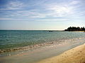
The Laguna de Tacarigua National Park [1] (Spanish : Parque nacional Laguna de Tacarigua), [2] also known as Tacarigua Lagoon National Park, is a protected area with the status of a national park [3] located east of Miranda State, close to the town of Laguna de Tacarigua in the South American country of Venezuela. [4] It comprises a permanent coastal lagoon of 7800 ha and 1.2 m of average depth, separated from the sea by a restinga or coastal barrier of 28.8 km long and 300–1000 m wide that was formed by the action of the sea current which runs along the coast in an East-West direction.

Contents

To the south of the lagoon extends an area dominated by dry forests and to the north, a marine area of 20,700 ha. In total the park covers 39,100 ha. Approximately 4,000 ha of the park are covered by mangrove forests that grow on the banks of the lagoon and even form dense islands towards the center. The lagoon is fed by fresh water mainly from the Guapo River but also from other tributaries such as the Pirital, San Nicolás, San Ignacio and Chaguaramal streams. In its northwestern sector the lagoon communicates with the sea through a mouth. In times of severe drought in the Guapo River basin, the decrease in freshwater intake and the accumulation of sediments cause mouth filling, and consequently an increase in the salinity of the lagoon waters.

The park comprises three main ecosystems: a shallow brackish lagoon, a dry forest area and a sandy beach barrier or reef.

See also

Related Research Articles

<span class="mw-page-title-main">Miranda (state)</span> State of Venezuela

Miranda State is one of the 23 states of Venezuela and the second most populous after Zulia State. As of the 2011 census, it had a population of 2,675,165 residents. It also has the greatest Human Development Index in Venezuela, according to the Venezuelan National Institute of Statistics. The most recent population estimate was 3,194,390 in mid-2016.

<span class="mw-page-title-main">Nueva Esparta</span> State in Venezuela

The Nueva Esparta State, is one of the 23 states of Venezuela. It comprises Margarita Island, Coche, and the largely uninhabited Cubagua.

<span class="mw-page-title-main">Laguna de Términos</span> Lagoon on the Gulf coast of Mexico

Laguna de Términos is the largest tidal lagoon by volume located entirely on the Gulf of Mexico, as well as one of the most biodiverse. Exchanging water with several rivers and lagoons, the Laguna is part of the most important hydrographic river basin in Mexico. It is important commercially, as well as ecologically by serving as a refuge for an extensive number of flora and fauna; its mangroves provide an important role as a refuge for migratory birds.

<span class="mw-page-title-main">Henri Pittier National Park</span>

Henri Pittier National Park is the oldest national park in Venezuela, originally created in 1937 under the name of Rancho Grande by decree of President Eleazar López Contreras. In 1953 the park was renamed in honor of Henri Pittier, a distinguished Swiss geographer, botanist and ethnologist, who arrived in Venezuela in 1917, classified more than 30,000 plants in the country and devoted many years studying the flora and fauna in the park.

Lagunas de Mejía National Sanctuary is a protected area on the coastal plain of Peru, in Islay Province, Arequipa, in the mouth of the Tambo River. It is a sanctuary for migratory and resident birds, and was designated a Ramsar site in 1992.

<span class="mw-page-title-main">Jaragua National Park</span> Reserve

Jaragua National Park is a national park of the Dominican Republic. Jaragua National Park is located in the Pedernales Province in the extreme southwest of the Dominican Republic. Jaragua National Park has a total area of 1,374 km², making it the largest protected area in the Caribbean region.

<span class="mw-page-title-main">Lagunas de Zempoala National Park</span>

Lagunas de Zempoala National Park is a natural protected area in Mexico that consists of a group of seven lagoons. In the Nahuatl language, "Zempoala" means "place of many waters." The park is located between the state of Morelos and the state of Mexico.

<span class="mw-page-title-main">Constitution 1857 National Park</span> National park in Baja California, Mexico

Constitution 1857 National Park is located in the pine forests of the Sierra de Juárez mountain range in the northern part of Baja California, Mexico. The park is an important preserve for many native wild animals like bighorn sheep and mule deer. The park is characterized by the large variety of coniferous plant species.

<span class="mw-page-title-main">Old Providence McBean Lagoon National Natural Park</span> National park in Colombia

The Old Providence McBean Lagoon National Natural Park is a national park located on the northeast side of Providencia Island in the Archipelago of San Andrés, Providencia and Santa Catalina, Colombia.

The Tamá National Natural Park is a national park located in the Tamá Massif of the Andean Region of Colombia, between the municipalities Toledo and Herrán, in the department of Norte de Santander, in the northeastern part of the Eastern Ranges of the Colombian Andes. One of the main attractions of the park is a 820-metre-high (2,690 ft) waterfall, one of the world's highest.

<span class="mw-page-title-main">Lagunas de Montebello National Park</span> National park in Chiapas, Mexico

Lagunas de Montebello, or Montebello Lakes, is a national park in the Mexican state of Chiapas, near the border with Guatemala, comprising 59 multi-colored lakes in a pine forest and two Maya ruins. It was the first national park in Chiapas when created in 1959, and in 2009 the park was designated a Biosphere Reserve by UNESCO.

<span class="mw-page-title-main">Laguna de la Restinga</span>

Laguna de la Restinga is a national park on the Isla Margarita, Nueva Esparta state, Venezuela. The main part of the park is a large salt lagoon, rich in fish and birdlife. It is on the Ramsar list of wetlands of international importance, and is classified as an Important Bird Area.

Protected areas of Panama include:

<span class="mw-page-title-main">Three Bays Protected Area</span>

Three Bays Protected Area, also known as Three Bays National Park, is a protected area in northeastern Haiti. It protects coral reefs, seagrass beds, mangrove forests, and dry forests.

<span class="mw-page-title-main">El Guache National Park</span> National park in Venezuela

The El Guache National Park Is a protected area with the status of national park in Venezuela, located at the beginning of the Andes mountain range, comprising mountainous parts of the Lara and Portuguesa states, and the birth of the Guache, Ospino, Toco, Morador and Are rivers. 2 In its adjacencies is the mighty waterfall San Miguel. It has an area of 12,200 ha traditionally measured and 15,960 Ha. Its temperature is between 19 °C. and 26 °C. Precipitation varies between 1800 and 2000 mm annually.

<span class="mw-page-title-main">Ciénagas del Catatumbo National Park</span>

The Ciénagas del Catatumbo National Park Also Catatumbo Marshes National Park or Ciénagas de Juan Manuel National Park Is a protected area of Venezuela.

<span class="mw-page-title-main">Turuépano National Park</span> National park in Venezuela

The Turuépano National Park Is a protected area with national park status in the South American country of Venezuela, located in the Benítez, Cajigal, Libertador and Mariño municipalities in the eastern part of Sucre State, north of the San Juan River and in front of the Gulf of Paria.

<span class="mw-page-title-main">Terepaima National Park</span>

The Terepaima National Park Is a protected area with the status of national park in the South American country of Venezuela located in the mountainous region of the Lara and Portuguesa States. Specifically southeast of the city of Barquisimeto, capital of the Lara State, it covers areas belonging to the municipalities Iribarren, Palavecino and Simón Planas.

<span class="mw-page-title-main">Mexican South Pacific Coast mangroves</span>

The Mexican South Pacific Coast mangroves ecoregion covers the mangrove sites along the coast of the Pacific Ocean coast of Mexico, across the states of Michoacán, Guerrero, and Oaxaca. These mangrove forests are mostly around lagoons, typically those fed by rivers from the interior in the Sierra Madre del Sur Mountains. The ecoregion is small: collectively, it covers only 1,295 km2.

References

  1. "Parque nacional Laguna de Tacarigua". Archived from the original on 2017-03-17. Retrieved 2017-03-16.
  2. Novo, Isabel (1997-01-01). Ciencia y Conservación en el Sistema de Parques Nacionales de Venezuela: Una Experiencia de Cooperación Interinstitucional (in Spanish). EcoNatura. ISBN   9789800742495.
  3. IUCN Directory of Neotropical Protected Areas. IUCN. 1982-01-01. p.  394. ISBN   9780907567622. Parque nacional Laguna de Tacarigua.
  4. Smith, Joel B.; Huq, Saleemul; Lenhart, Stephanie; Mata, Luis José; Nemesová, Ivana; Touré, Sekou (2013-03-09). Vulnerability and Adaptation to Climate Change: Interim Results from the U.S. Country Studies Program. Springer Science & Business Media. ISBN   9789401736534.