
Laim (Central Bavarian: Loam) is a district of Munich, Germany, forming the 25th borough of the city. It had around 49,000 inhabitants in 2005.
Laim (Central Bavarian: Loam) is a district of Munich, Germany, forming the 25th borough of the city. It had around 49,000 inhabitants in 2005.

Originally its own independent locality, Laim was in existence before Munich. It was first documented between 1047 and 1053 as loco leima (in Leim village). The municipality was formed in 1818 and consolidated into Munich on 1 January 1900. At that time the village centre was Laim meadow, which was inaugurated on its return to the people on 1 and 2 July 2000, with festivities celebrating the 100 year incorporation of Laim into Munich. Opposite the meadow is the Catholic St. Ulrich-Kirche (St. Ulrich's Church). The name Leim comes from the German word Lehm meaning clay and Lehmboden meaning clay soil. Earlier Laim used the 21 series post code, however nowadays the codes 80686 - 80689 are utilised.
Laim is not to be confused with Berg am Laim, the 14th borough of Munich 10 km away to the east.
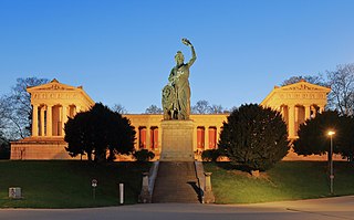
Theresienwiese is an open space in the Munich borough of Ludwigsvorstadt-Isarvorstadt. It serves as the official ground of the Munich Oktoberfest. A space of 420,000 square metres (4,500,000 sq ft), it is bordered in the west by the Ruhmeshalle and the Bavaria statue, symbolizing the State of Bavaria, and in the east by Esperantoplatz, a square named for the international language Esperanto. There, a memorial commemorates the victims of the 1980 Oktoberfest bombing. Bavariaring, an orbital road, provides access to visiting traffic. In the north the towers of the Paulskirche are visible.

St Michael in Berg am Laim is a church in Munich, Bavaria, built from 1738 to 1751 by Johann Michael Fischer as Court Church for Elector and Archbishop Clemens August of Cologne, a brother of Emperor Charles.

Sendling-Westpark is the 7th borough of Munich.

Kreillerstraße is a Munich U-Bahn station on line U2.

Altstadt and Lehel are districts of the German city of Munich. Together they form the first borough of the city: Altstadt-Lehel.

Aubing-Lochhausen-Langwied is the 22nd borough of the German city of Munich. The districts Aubing, Lochhausen and Langwied were incorporated together in 1942, thus forming the largest borough of the city at 3,400 hectares, yet having the lowest density of population with 37,352 residents as of 2002. This large borough still accommodates many vast agricultural and forest areas that together with the Aubinger Lohe and the Langwieder lake district, fulfill the balance of nature in the area and offer recreational facilities to all of western Munich.

Au-Haidhausen is the 5th borough of the German city of Munich, Bavaria. It is formed by the Au and Haidhausen districts.

Au is a district in the south eastern plain tract of the German city of Munich in Bavaria. Au extends from the Deutsches Museum in the north and along the Isar up to Wittelsbacherbrücke in the south.

Trudering-Riem is the 15th borough (Stadtbezirk) of Munich, Bavaria, consisting of the quarters (Stadtteile) Trudering and Riem. This area is the former location of Munich's old airport, Riem Airport.

The Hochhaus Süddeutscher Verlag in Munich houses the headquarters of said publishing house, Süddeutsche Zeitung and the German School of Journalism. It is located in the commercial area of the Zamdorf neighborhood, part of the Berg am Laim district, between the A 94 motorway and the Berg am Laim S-Bahn station.

Haidhausen is a quarter of Munich, Germany. It is now part of the borough—or stadtbezirk—number 5 Au-Haidhausen.

The Karmelitenkirche or Carmelite Church of St. Nicholas is a Baroque former church at Karmeliterstraße in Munich, Germany. It was built in 1654 to plans by Hans Konrad Asper by Marx Schinnagl as a replacement for the old Carmelite Church. The monastery church was consecrated in 1660. Today it is used as an oratory for the library and reading room of the Metropolitan Chapter of Munich. It is also used for the Archives of the Archdiocese of Munich and Freising.
St. Anna im Lehel is a parish of the Roman Catholic Church in the Lehel district of Munich. Founded in 1808, it is staffed by Franciscans from the adjacent abbey of St. Anna.

The Hachinger Bach is a river in Bavaria, Germany. It flows southwards of Munich, through the townships of Oberhaching, Taufkirchen, Unterhaching and Unterbiberg, and enters the Munich city area in Perlach. It is twelve kilometers long.

The Shopping mall Fünf Höfe in the center of Munich was created from 1998 to 2003 after the coring of a HypoVereinsbank building complex. In 2004, the Fünf Höfe was sold to DIFA and since then the official name has been CityQuartier Fünf Höfe.

Maxvorstadt is a central borough of Munich, Bavaria, Germany and forms the Stadtbezirk (borough) 3 Maxvorstadt. Since 1992, this borough comprises the former boroughs 5, 6 and 7.

Berg am Laim is a southeastern borough of Munich, Bavaria, Germany.

Munich North Ring, section of which are only used by freight trains, is a railway bypass on the northern edge of the Bavarian state capital of Munich. The line’s importance for freight also partly arises from its access to the Munich North marshalling yard.

Neuperlach is a borough in the southeast of the Bavarian capital, Munich and is part of the city district no. 16, Ramersdorf-Perlach. It was built starting in 1967 east of the former village of Perlach on the ground of the former Perlacher Haid. Neuperlach is located east of the boroughs Ramersdorf and Perlach, south of the city districts no. 14 and no. 15 (Trudering-Riem), west of the borough Waldperlach and north of Unterbiberg. The borough encompasses multiplehousing estates, including several high-rise estates, and is one of Germany's biggest satellite towns. In the center of Neuperlach, the large pep shopping mall is located, one of the most profitable shopping centers in Germany. The Hachinger Bach runs through the western part of Neuperlach from north to south. The stream also passes through the western part of the Ostpark.

Großhadern is a district in the south-west of the Bavarian state capital Munich. Großhadern is primarily a bourgeois residential area. Exceptions are the so-called "village core" with numerous small shops as well as the university district around the Klinikum Großhadern. This includes several student halls and three football fields. The number of restaurants and beer gardens is also remarkably high. In the south-west of Großhadern, between the subway station "Klinikum Großhadern" and the adjacent forest, a new settlement is being built on a former field with owned and rented apartments as well as some shops. Many of the houses are already finished and lived in. The old church of St. Peter is located in the village center, not far from it, the parish church of St. Canisius, built in 1925, with the Stations of the Cross by Kaspar Schleibner. The Protestant church has its home in the Reformation Memorial Church. A large part of the Großhadern area is in the south-west of the Waldfriedhof.