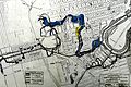
Lairet River

Last updated
Lairet River
Riviere Lairet.jpg
Location
CountryCanada
Province Quebec
Region Capitale-Nationale
Regional County Municipality Quebec City (sector "Limoilou")
Physical characteristics
SourceLairet Canal
  location Quebec (city) (sector "Limoilou")
  coordinates 46°49′31″N71°14′26″W / 46.82528°N 71.24056°W / 46.82528; -71.24056
Mouth Rivière Saint-Charles
  location
Quebec (city) (sector "Limoilou")
  coordinates
46°49′26″N71°14′20″W / 46.82389°N 71.23889°W / 46.82389; -71.23889 Coordinates: 46°49′26″N71°14′20″W / 46.82389°N 71.23889°W / 46.82389; -71.23889
  elevation
10 m
Length0.3 km (0.19 mi)

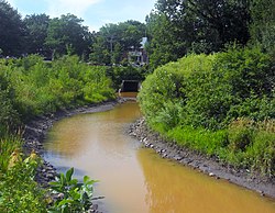
The Lairet River is a tributary of the Saint-Charles River, crossing Quebec City, Quebec, Canada. Over two kilometers long, it took its source in the vicinity of Charlesbourg and flowed in meanders in Limoilou. It has been completely channeled since the 1960s, [1] except for a segment refitted in 2008.

Contents

Geography

Last tributary of the North shore of Saint-Charles river before it flows into the Saint-Laurent river, the Lairet river was once several tens of kilometers long. It originally took its source north of seigniory Saint-Ignace, west of trait-carré de Charlesbourg. It then headed southeast towards Limoilou where it widened and consisted of small meanders.

History

The river in 1886. The Little River Lairet - Quebec.jpg
The river in 1886.

On September 14, 1535, the river was seen for the first time by French explorer Jacques Cartier. Cartier and his crew overwinter at the confluence of the Lairet River and the Saint-Charles River, near the village St. Lawrence Iroquoians of Stadaconé. In New France, the name of the river appeared for the first time on a document in 1626 (designated "Rivière de Lairet" in 1637 and "Rivière de Larray" in 1685). The Jesuits also used the name "Jacques-Cartier river" in 1651, probably in connection with the Jacques-Cartier fort, a Jesuit residence built at the mouth of the river from 1625. Jean-Baptiste Larue used the toponym “Rivière à la Rez” in 1821. [2] Until XXth, the course of the river retains its natural state and crosses agricultural land.

The industrialization of Limoilou reveals several industries and institutions near the Lairet river in the first half of XXth Century. In this urbanized segment, the river gradually becomes an open sewer. In addition, the winding course is an obstacle in the construction of grid lines streets. The pipeline is requested by different owners. On March 15, 1960, the member for Québec-Est, Armand Maltais, announced the start of work on pipeline from the river. This work will take place in three phases (1960, 1965 and 1967). [3] Finally, the river is channeled to its mouth with the Saint-Charles River passing under the Cartier-Brébeuf National Historic Site. This work then became part of the concreting of the banks of the Saint-Charles river, which was completed in the 1970s.

The river in 2016. Riviere Lairet 2.jpg
The river in 2016.

Parts of the pipeline collapsed in the 2000s in Cartier-Brébeuf Park. [4] During these same years, Quebec City undertook the demolition of the concrete walls of the Saint-Charles river as well as the renaturalization of the banks [5] In parallel with this work, the Lairet river pipeline is removed over a length of approximately 300 meters (980 ft), [2] at its confluence with the Saint-Charles river. However, the majority of the course of the river is still underground. The Saint-François d'Assise hospital, originally built on the banks of the river, is nowadays struggling with water infiltration. [6]

Related Research Articles

<span class="mw-page-title-main">Boroughs of Quebec City</span>

Quebec City is divided into six arrondissements or boroughs. These boroughs are the result of several waves of amalgamation and reorganization of the political boundaries of Quebec City.

<span class="mw-page-title-main">Jacques-Cartier River</span> River of Capitale-Nationale (Québec, Canada)

The Jacques-Cartier River is a river in the province of Quebec, Canada. It is 161 km long and its source is Jacques-Cartier Lake in Laurentides Wildlife Reserve, and flows in a predominantly southern direction before ending in the Saint Lawrence River at Donnacona, about 30 km upstream from Quebec City.

<span class="mw-page-title-main">Saint-Charles River (Quebec City)</span> River in Quebec City in Canada

The Saint-Charles River is the main watercourse crossing Quebec City, Quebec, Canada.

<span class="mw-page-title-main">La Cité-Limoilou</span> Borough of Quebec City in Canada

La Cité-Limoilou is the central borough of Quebec City, the oldest, and the most populous, comprising 21.85% of the city's total population. As an administrative division, it is very new, having only been formed on November 1, 2009, from the former boroughs of La Cité and Limoilou.

<span class="mw-page-title-main">Cartier-Brébeuf National Historic Site</span> Historic site in Quebec City, Quebec

Cartier-Brébeuf National Historic Site is a National Historic Site of Canada and so designated by the Historic Sites and Monuments board of Canada in 1958 under the recommendation of John Diefenbaker, the Prime Minister of Canada at the time. It is administered by Parks Canada and located at the confluence of Saint-Charles and Lairet rivers, in Quebec City, Quebec, Canada, more precisely in La Cité-Limoilou borough. On the site you can find an interpretation centre and a 6,8 hectares inner-city park characterised by an uneven landscape and divided into two sectors "East" and "West" separated by the Lairet river. Several commemorative monuments and elements are also present.

<span class="mw-page-title-main">Rivière du Cap Rouge</span> River in Quebec, Canada

The Cap-Rouge river is a river flowing on the north shore of the Saint-Laurent river at the height of the Sainte-Foy–Sillery–Cap-Rouge borough of Quebec City and in the city of Saint-Augustin-de-Desmaures, both cities in the administrative region of Capitale-Nationale, in the province of Quebec, Canada.

The Petit lac Jacques-Cartier is a freshwater body that flows into the rivière Jacques-Cartier Sud, in the unorganized territory of Lac-Jacques-Cartier, in the La Côte-de-Beaupré Regional County Municipality, in the administrative region of Capitale-Nationale, in province from Quebec, in Canada.

The Jacques-Cartier South River is a tributary of the rivière Jacques-Cartier Nord-Ouest, located in the unorganized territory of Lac-Jacques-Cartier, in the La Côte-de-Beaupré Regional County Municipality, in the administrative region of Capitale-Nationale, in Quebec, Canada. The course of the river passes in particular in the Jacques-Cartier National Park. The head water is Petit lac Jacques-Cartier.

The rivière du Malin is a tributary of the Jacques-Cartier River, located in the unorganized territory of Lac-Jacques-Cartier, in the La Côte-de-Beaupré Regional County Municipality, in the administrative region of Capitale-Nationale, in Quebec, Canada. The course of the river passes in particular in the Laurentides Wildlife Reserve.

<span class="mw-page-title-main">Sautauriski River</span> River in Quebec, Canada

The Sautauriski River is a tributary of the Jacques-Cartier River, flowing in the administrative region of Capitale-Nationale, in Quebec, Canada. This watercourse subsequently crosses:

<span class="mw-page-title-main">Rivière à l'Épaule</span> River in Quebec, Canada

The Rivière à l'Épaule is a tributary of the Jacques-Cartier River, flowing in the administrative region of Capitale-Nationale, in Quebec, Canada. The course of the river crosses the unorganized territory of Lac-Jacques-Cartier in the La Côte-de-Beaupré Regional County Municipality, as well as the township municipality unis de Stoneham-et-Tewkesbury, located in the MRC La Jacques-Cartier Regional County Municipality.

The Rivière Ontaritzi is a tributary of the Jacques-Cartier River, flowing in the municipality of Sainte-Catherine-de-la-Jacques-Cartier, in the La Jacques-Cartier Regional County Municipality, in the administrative region of Capitale-Nationale, in Quebec, Canada.

The rivière aux Pommes is a tributary of the Jacques-Cartier River, flowing in the municipalities of Sainte-Catherine-de-la-Jacques-Cartier, Pont-Rouge, Neuville and Donnacona, in the Portneuf Regional County Municipality, in the administrative region of Capitale-Nationale, in Quebec, Canada.

The Rivière aux Pins is a tributary of the Montmorency River, which is a tributary of the north shore of the St. Lawrence River, flowing in Sainte-Brigitte-de-Laval, in the of La Jacques-Cartier Regional County Municipality, in the administrative region of Capitale-Nationale, in the province of Quebec, in Canada.

<span class="mw-page-title-main">Nelson River (Saint-Charles River tributary)</span> River in Quebec, Canada

The Nelson River is located in the administrative region of Capitale-Nationale, in province of Quebec, in Canada. It is part of the watershed of the Saint-Charles River. The course of this river crosses:

<span class="mw-page-title-main">Jaune River (Saint-Charles River tributary)</span> River in Capitale-Nationale (Québec, Canada)

The Jaune River is a tributary of the Saint-Charles River flowing in the administrative region of Capitale-Nationale, in the province of Quebec, Canada. The course of the river crosses:

<span class="mw-page-title-main">Linear park of the Saint-Charles and Berger rivers</span>

The linear park of the Saint-Charles and Berger rivers is a linear park public of the Quebec city. It runs along the rivers Saint-Charles and du Berger between Saint-Charles Lake and port of Québec. It has a 32 km footpath and a 8 km cycle path on Rivière-Saint-Charles Corridor.

The rivière Noire is a tributary of the rivière des Hurons, flowing in the heart of the municipality of the townships of Stoneham-et-Tewkesbury, located north of the city of Quebec, in the La Jacques-Cartier Regional County Municipality, in the administrative region of the Capitale-Nationale, in the province of Quebec, in Canada.

The Rivière des Roches is a tributary of the west bank of the Sainte-Anne River, on the north bank of the Saint Lawrence River. This river flows in the unorganized territory of Lac-Jacques-Cartier and in the municipality of Saint-Ferréol-les-Neiges, in the La Côte-de-Beaupré Regional County Municipality, in the administrative region of Capitale-Nationale, in the province of Quebec, in Canada.

References

Map all coordinates using: OpenStreetMap  
Download coordinates as: KML
  1. [ dead link ]
  2. 1 2 Commission de toponymie du Québec
  3. "Chronique d'une rivière disparue (8 et fin) : Canalisation de la Lairet - Mon Limoilou". blogue.monlimoilou.com. Archived from the original on 20 August 2016. Retrieved 14 January 2022.
  4. News - Canada.ca
  5. Québec Urbain, Parc Cartier-Brébeuf - La rivière Lairet à Découverte, 2008. "Online presentation". April 15, 2010.
  6. Article from La Presse and from the newspaper Le Sun.