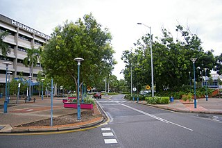
Darwin is the capital city of the Northern Territory of Australia, situated on the Timor Sea. With a 2018 estimated population of 148,564, it has more residents than the rest of the sparsely populated Northern Territory. It is the smallest, wettest, and most northerly of the Australian capital cities and serves as the Top End's regional centre.

The Northern Territory is an Australian territory in the central and central northern regions of Australia. It shares borders with Western Australia to the west, South Australia to the south, and Queensland to the east. To the north, the territory looks out to the Timor Sea, the Arafura Sea and the Gulf of Carpentaria, including Western New Guinea and other islands of the Indonesian archipelago.
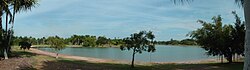
Palmerston is a planned satellite city of Darwin, the capital and largest city in Australia's Northern Territory. It is situated approximately 20 kilometres from Darwin and 10 kilometres from Howard Springs and the surrounding rural areas. Palmerston had a population of 33,695 at the 2016 census, making it the second largest city in the Northern Territory.
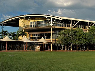
Charles Darwin University (CDU) is an Australian public university with a main campus in Darwin and eight satellite campuses in some metropolitan and regional areas. It was established in 2003 after the merger of Northern Territory University, the Menzies School of Health Research, and Centralian College.
The Administrator of the Northern Territory is an official appointed by the Governor-General of Australia to represent the government of the Commonwealth in the Northern Territory. He or she performs functions similar to those of a state governor.

Cyclone Tracy was a tropical cyclone that devastated the city of Darwin, Northern Territory, Australia from 24 to 26 December 1974.

The Top End of Australia's Northern Territory is a geographical region encompassing the northernmost section of the Northern Territory, which aside from the Cape York Peninsula is the northernmost part of the Australian continent. It covers a rather vaguely defined area of perhaps 245,000 km² behind the northern coast from the Northern Territory capital of Darwin across to Arnhem Land with the Indian Ocean on the west, the Arafura Sea to the north, and the Gulf of Carpentaria to the east, and with the almost waterless semi-arid interior of Australia to the south, beyond the huge Kakadu National Park.

Katherine is a town in the Northern Territory of Australia. It is situated on the Katherine River below the "Top End", 320 kilometres (200 mi) southeast of Darwin. It is the fourth largest settlement in the Territory and is known as the place where "The outback meets the tropics". Katherine had an urban population of approximately 6,300 at the 2016 Census.

Stuart Highway is one of Australia's major highways. It runs from Darwin, in the Northern Territory, via Tennant Creek and Alice Springs, to Port Augusta in South Australia; a distance of 2,834 km (1,761 mi). Its northern and southern extremities are segments of Australia's Highway 1. The principal north-south route through the central interior of mainland Australia, the highway is often referred to simply as "The Track".

Rum Jungle is a locality in the Northern Territory of Australia located about 105 kilometres south of Darwin on the East Branch of the Finniss River. It is the site of a uranium deposit, found in 1949, which has been mined.

Darwin International Airport is the busiest airport serving the Northern Territory and the tenth busiest airport in Australia. It is the only airport serving Darwin.

RAAF Base Darwin is a Royal Australian Air Force (RAAF) military air base located in the city of Darwin, in the Northern Territory, Australia. The base shares its runway with Darwin International Airport, for civil aviation purposes. The heritage-listed RAAF Base Darwin is a forward operating base with year-round activity with approximately 400 personnel.

RAAF Base Tindal is a Royal Australian Air Force (RAAF) military air base and civil aviation airfield located 8 nautical miles east southeast of the town of Katherine, Northern Territory in Australia. The base is currently home to No. 75 Squadron and a number of non-flying units, and also hosts the Katherine Tindal Civilian Airport. First constructed in 1942, it was refurbished in the late 1960s as a "bare base" capable of being utilised when required. It was opened as a permanently manned RAAF base in 1989.

Daly River is the name of a river and a town in the Northern Territory of Australia. At the 2006 census, Daly River had a population of 468. The town is part of the Victoria Daly Region local government area. Settlement on the river is centred on the Aboriginal community of Nauiyu, originally the site of a Catholic mission, as well as the town of Daly River itself, at the river crossing a few kilometres to the south. The area is popular for recreational fishing, being regarded as one of the best places to catch Barramundi in Australia. The Daly River is part of the Daly Catchment that flows from northern Northern Territory to central Northern Territory.

Batchelor is a town in the Northern Territory of Australia. The town is the current seat and largest town of the Coomalie Shire local government area. It is located 98 kilometres (61 mi) south of the territory capital, Darwin. A number of residents commute to Darwin and its suburbs for work. In the 2016 census, Batchelor recorded a population of 507 people, with 36% of Aboriginal and Torres Strait Islander origin.
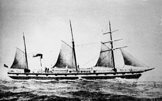
The SS Gothenburg was a steamship that operated along the British and then later the Australian and New Zealand coastlines. In February 1875, Gothenburg left Darwin, Australia and while en route to Adelaide it encountered a cyclone-strength storm off the north Queensland coast. The ship was wrecked on the Great Barrier Reef north-west of Holbourne Island on 24 February 1875. Survivors in one of the lifeboats were rescued two days later by Leichhardt, while the occupants of two other lifeboats that managed to reach Holbourne Island were rescued several days later. Twenty-two men survived, while between 98 and 112 others died, including a number of high-profile civil servants and dignitaries.

Power and Water Corporation is a Northern Territory Government owned corporation in the Northern Territory. Power and Water is the Northern Territory's premier provider of electricity, water and sewerage services. The Power and Water Corporation was formed on 1 July 2002, taking over from the former government utility Power and Water Authority. Power and Water became the first Government – owned corporation in the Northern Territory. The corporation has more than 142,120 customers.
Hughes Airfield is an airfield in the Northern Territory of Australia located in the locality of Hughes. It was constructed during World War II for military use. The airfield now functions as a base for aerial firefighting aircraft to protect the outer rural suburbs of Darwin.
Lake Woods is an ephemeral freshwater lake in the Northern Territory of Australia. It lies on Newcastle Creek close to the small town of Elliott on the Stuart Highway, about halfway between Darwin and Alice Springs. It is important as a breeding site for waterbirds.

Vestey's Meatworks, officially the North Australia Meat Company, was a slaughterhouse in Darwin, Northern Territory, Australia, built by Vestey Brothers between 1914 and 1917. Never profitable, it operated for three years before the company abandoned the venture in the aftermath of the Darwin rebellion. Most of the facility was demolished in 1957, but two large water tanks are still standing today, on what is now the site of the Darwin High School on Bullocky Point in the suburb of The Gardens. The beach to the north of Bullocky Point is called Vestey's beach as a result of the meatworks.