
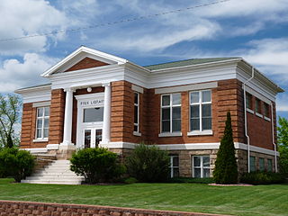
Taylor County is a county in the U.S. state of Wisconsin. As of the 2020 census, the population was 19,913. Its county seat is Medford. It is mostly rural, lying roughly where corn and dairy farms to the south give way to forest and swamp to the north.
Rusk County is a county in the U.S. state of Wisconsin. As of the 2020 census, the population was 14,188. Its county seat is Ladysmith. The Chippewa and Flambeau rivers and their tributaries flow through the county. The land ranges from corn/soybean farms and dairy farms to lakes rimmed with vacation homes to hiking trails through the Blue Hills.

Chippewa County is a county located in the U.S. state of Wisconsin. It is named for the historic Chippewa people, also known as the Ojibwe, who long controlled this territory. As of the 2020 census, the population was 66,297. Its county seat is Chippewa Falls. The county was founded in 1845 from Crawford County, then in the Wisconsin Territory, and organized in 1853.

Lake Holcombe is a town in Chippewa County in the U.S. state of Wisconsin. Its population was 1,031 at the 2010 census. The census-designated place of Holcombe is located in the town.

Grover is a town in Taylor County, Wisconsin, in the United States. As of the 2010 census, the town population was 256. The unincorporated community of Perkinstown is located in the town.

Molitor is a town in Taylor County, Wisconsin, United States. The population was 324 at the 2010 census.

The Driftless Area, also known as Bluff Country and the Paleozoic Plateau, is a topographical and cultural region in the Midwestern United States that comprises southwestern Wisconsin, southeastern Minnesota, northeastern Iowa, and the extreme northwestern corner of Illinois. The Driftless Area is a USDA Level III Ecoregion: Ecoregion 52. The Driftless Area takes up a large portion of the Upper Midwest forest–savanna transition. The eastern section of the Driftless Area in Minnesota is called the Blufflands, due to the steep bluffs and cliffs around the river valleys. The western half is known as the Rochester Plateau, which is flatter than the Blufflands. The Coulee Region is the southwestern part of the Driftless Area in Wisconsin. It is named for its numerous ravines.
The Bad River is a river flowing to Lake Superior in northern Wisconsin in the United States. It flows for 119.6 kilometres (74.3 mi) in Ashland County, draining an area of 1,061 square miles (2,750 km2) in portions of Ashland, Bayfield and Iron counties. The Bad River sloughs were designated a Ramsar Wetland of International Importance on February 2, 2012.

The Chippewa River in Wisconsin flows approximately 183 miles (294 km) through west-central and northwestern Wisconsin. It was once navigable for approximately 50 miles (80 km) of its length, from the Mississippi River, by Durand, northeast to Eau Claire. Its catchment defines a portion of the northern boundary of the Driftless Area. The river is easily accessible for bikers and pleasure seekers via the Chippewa River State Trail, which follows the river from Eau Claire to Durand.
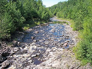
The Yellow River in north central Wisconsin is a tributary of the Chippewa River. For the most part it is a mud and rock-bottomed river flowing through forest and farmland. It is one of four distinct rivers in the state bearing the name Yellow River.

The Flambeau River is a tributary of the Chippewa River in northern Wisconsin, United States. The Chippewa is in turn a tributary of the upper Mississippi River. The Flambeau drains an area of 1,860 square miles (4,800 km2) and descends from an elevation of approximately 1,570 feet (480 m) to 1,060 feet (320 m) above sea level. The Flambeau is an important recreational destination in the region. It is notable among canoeists in the Midwest for outstanding canoe camping, including excellent scenery, fishing and whitewater. The river and its forks have a variety of possible trip lengths from short day outings, to overnight camping, to voyages of a week or more.
Clam Lake is an unincorporated, census-designated place in the town of Gordon in Ashland County, Wisconsin, United States. It is located on Wisconsin Highway 77 near County Highway GG. The entire area lies within the Chequamegon National Forest, an 860,000 acre area spread across northern Wisconsin. As of the 2010 census, its population was 37.
The Pine Island State Forest is a Minnesota state forest located primarily in Koochiching County, although there are portions that extend into Beltrami, Lake of the Woods, and Itasca counties. The forest borders the Koochiching State Forest to the east, the Red Lake State Forest to the west, and Big Fork State Forest and Chippewa National Forest to the south. At an area of 878,040 acres (355,330 ha), it is the largest state forest in Minnesota.

Holcombe Flowage is a reservoir on the Chippewa River in Chippewa County and Rusk County, Wisconsin. The dam stands between the towns of Birch Creek and Lake Holcombe, just west of the settlement of Holcombe, Wisconsin, in Chippewa County, where most of the reservoir lies. A small part of the reservoir also extends northward into the Town of Willard in Rusk County.

The Turtle-Flambeau Flowage is a 12,942 acres (52.37 km2) lake in Iron County, Wisconsin. It has a maximum depth of 15 meters and is the seventh largest lake in the state of Wisconsin by surface area. The flowage is home to unique wetland patterns and plant species as well as several species of sport and game fish, including musky, panfish, largemouth bass, smallmouth bass, northern pike, walleye and sturgeon. The lake's water clarity is low, but can vary in different locations. Fishing, camping, boating, and hunting are popular activities on the flowage, and Ojibwe people traditionally harvest fish and game on the lake. Environmental concerns on the flowage include mercury contamination, algal blooms, and several types of invasive species.
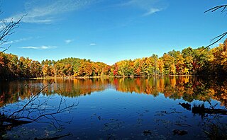
Dorothy Lake State Natural Area is a Wisconsin Department of Natural Resources-designated State Natural Area featuring forested end moraine topography, with many steep-sided ridges and depressions. This results in a diverse mosaic of natural communities, including forests, swamps, fens, lakes, and streams.
Chippewa Moraine Lakes is a Wisconsin Department of Natural Resources-designated State Natural Area that comprises nine separate sites, spread out over roughly 30 square miles (78 km2). Each site features a primarily undisturbed lake located within the rough terminal moraine topography of northern Chippewa County. Each lake has its own unique species assemblage due to physical and chemical characteristics of the lake. The nine lakes are: Camp Lake, a 6-acre lake ringed by a floating sphagnum bog mat containing such plant species as white beak rush, narrow-leaved sundew, small cranberry, and grass pink orchid. Spence Lake, a 12-acre, acidic bog lake that is the headwaters of Foster Creek. Conifer swamp surrounds the northern part of the lake, hardwood swamp surrounds the central part, while the southern part is largely a sedge meadow, impacted by beaver activity. Bass Lake #1, a 6-acre soft-water seepage lake, with at least one rare plant species present. Bass Lake #5, an 8-acre, deep, hard-water seepage lake that is the main headwaters branch of Mud Creek. Deer Lake, a 6-acre seepage lake that is also part of the headwaters of Mud Creek. Burnt Wagon Lake, a 15-acre softwater seepage lake that is landlocked, with no development. Fishpole Lake, an 11-acre meromictic lake. Due to its size, shape, and depth, the lake's water column is permanently thermally stratified, unlike most Wisconsin lakes, leading to unique chemical and biological characteristics. Plummer Lake, a 41-acre, deep, hard-water seepage lake. Little Plummer Lake, a 10-acre wild hardwater seepage lake that drains into Plummer Lake.
East River Sheet Harbour is a river on the Eastern Shore of Nova Scotia, Canada, in the Halifax Regional Municipality. Its headwaters are at the Marshall Flowage near Malay Falls and the mouth of the river is at the head of the Northeast Arm in Sheet Harbour, Nova Scotia.

