Lake Effie is a very irregularly-shaped lake just west of Highway US 27, on the west edge of Lake Wales, Florida. This lake has a 105-acre (420,000 m2) surface area. A cove on the west side of Lake Effie is mostly swamp. On the east side is the Florida's Natural Growers Visitor's Center, known as the Grove House. Florida's Natural has a large citrus processing plant east of the Grove House, on the east side of US 27.
Lake Weaver is a natural freshwater lake located in Lake Wales, Florida. The lake is also much of the time called Lake Weader. By looking at maps and websites, it appears both names are used as often as the other. The lake is on the north side of Central Avenue and just east of US Highway 27. Across the street on Central are businesses and to the lake's southeast are businesses. On the northeast shore is a residential area. To the north is a wooded area.
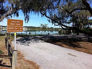
Lake Roy is a natural freshwater lake inside the city of Winter Haven, Florida. It has a 74.17-acre (300,200 m2) surface area and is located on the south side of Cypress Gardens Boulevard. The lake once had a larger surface area, but when Cypress Gardens Boulevard was upgraded it ran over some of the northern part of Lake Roy; this part had been filled so the road could be rerouted. A small part of the old lakebed is north of the street, but is more of a retention pond now, for the most part remaining dry. The lake is of an irregular shape. Lake Roy is connected by a canal on its southwest side to Lake Lulu and indirectly from there to more than twenty other area lakes. These lakes are linked by canals and are known locally as the Chain of Lakes. Most of the shore of Lake Roy is bordered by residential housing. Residential areas circle from the southeast around to the northwest side of the lake. Along Cypress Gardens Boulevard on the northwest are businesses and a hotel, Lake Roy Beach Inn, is on this street at the northeast corner of the lake.
Lake Ina is about 1,000 ft (305 m) east of Lake Roy. Lake Ina is inside the city of Winter Haven, Florida, and is bordered by Cypress Garden Boulevard on its north. In fact, a bridge carries this street over the extreme northern edge of the lake. Lake Ina has a 8.99-acre (36,400 m2) surface area. The lake is irregularly shaped and is bordered from its northeast side to its southwest side by residences. Vacant grassland borders the rest of the west side.
Lake Ruby is a natural freshwater lake in the suburbs southeast of Winter Haven, Florida. Lake Ruby has a 259-acre (1,050,000 m2) surface area. It is one block south of Cypress Gardens Boulevard. Lake Ruby Drive borders most of the lake's north side. All of the west shore, the southwest shore and the northeast shore is bordered by gated residential communities. The south side of the lake is bordered by private land and just to the east-southeast is Lake Bess. A narrow strip of land, at its narrowest point 40 feet (12 m), separates the two lakes.
Lake Bess is a natural freshwater lake southeast of Winter Haven, Florida. It is pear shaped and has a 147-acre (590,000 m2) surface area. Two blocks from its northeast shore is a WalMart supercenter and just north of that is Cypress Gardens Boulevard. On its north-northwest side is a gated residential community. To its west is Lake Ruby. The two lakes are separated by a 40 feet (12 m) strip of land. On its south-southwest shore are residential developments. On its southeast is pastureland. On its east-northeast shore are two country clubs and mobile homes.
Lake Easy is a natural freshwater lake with a 407-acre (1,650,000 m2) surface area. The lake is somewhat oval in shape and sometimes has a small island in its southeast part, depending on the lake level at the time. Lake Easy is bounded on its north by the incorporated village of Highland Park, which is also a golf resort. On its west side is grassland and a residential development. To the southwest are a citrus orchard and pastureland. On the southeast is residential housing along Lake Easy Road. Along its east side is public land.

Lake Moody is a natural freshwater lake with a 409-acre (1,660,000 m2) surface area. Shaped somewhat like a flint arrowhead, Lake Moody is in an area of sparse residential development. A scattering of residences, as well as citrus groves, are on the south side of the lake along South Lake Moody Road. On the west side the lake is bordered by the Scenic Route of Highway 17. A few residences line the west side of the highway and the shore on west side is all private property. Most of the area along the highway is bordered by citrus groves. North Lake Moody Road borders the northwest part of the lake. The shore borders much of the road right-of-way on this road. Lake Moody is bordered on the northeast by citrus groves and some swampy areas of ground. A railroad line, more swamp and citrus groves line the east shore.
Lake Summit is a natural freshwater lake in Winter Haven, Florida. It has a 65.97-acre (267,000 m2) surface area and is somewhat oval in shape. It has two small coves on its north side. This lake is surrounded by residences around most of its perimeter. It has a public park, Lake Summit Park, on part of its west side, and Legoland Florida's water park is on its southeast shore. A boat canal on the south side of Lake Summit leads to Lake Eloise.
Lake Lulu is a natural freshwater lake in Winter Haven, Florida. The lake has a 315-acre (1,270,000 m2) surface area and has a somewhat irregular oval shape. It is bounded on the north and northeast by private residences. It has no eastern or western sides, as the lake's shore comes to a point on those two sides. At the eastern point, it is bounded by West Lake Eloise Drive and about 75 feet (23 m) beyond that is Lake Eloise. The entire south side of the lake is lined with a swampy area and a dense growth of trees.
Lake Mariam is roughly oval in shape and is on the northeast side of Winter Haven, Florida. The Polk County Water Atlas says sometimes the lake is known as Lake Marion, but a different Lake Marion is also in Polk County, Florida, where Lake Mariam is located. It has a surface area of 200 acres (809,371 m2) and is bordered on the west side, most of the south side and part of the north side by residential areas. Brandywine Health Care Center, a nursing home, is a block north of the lake. On the northwest and southwest Lake Mariam is bordered by woods and on most of the east side of the lake are woods and pastureland. On the lake's southeast side is a swampy area.
Lake Martha, oval in shape, is in the west-central part of Winter Haven, Florida. Lake Martha Drive surrounds two-thirds of the lake's perimeter. Lake Martha has a 84.38-acre (341,500 m2) surface area. On the northeast is a public park and boat ramp and across the street from this park is the Winter Haven campus of Polk State College. Winter Haven Hospital is on the lake's west side and a public park is at the southwest side of the lake. Residential housing surrounds the rest of the lake.
Lake Florence is a tear-shaped natural freshwater lake in east-central Winter Haven, Florida. This lake has a 72.59-acre (293,800 m2) surface area. It is surrounded on all but its east and northeast sides by residential areas. On the east it is bordered by woods and on the northeast it is bordered by a citrus grove.
Lake Ring, is a tiny lake in eastern Winter Haven, Florida, which is almost round in shape. This lake is a natural freshwater lake with a 3.3-acre (13,000 m2) surface area. This lake is bordered on all sides by residences along Lake Ring Drive.
Lake Smart is a round natural freshwater lake, with a semicircular cove on its northwest side, on the northeast side of Winter Haven, Florida. Lake Smart has a water area of 277-acre (1,120,000 m2). This lake is mostly surrounded by woods and citrus groves. On its north and west sides it is bordered by residential developments. On the northwest Florida State Route 544 runs along Lake Smart's cove.
Lake Gem is a round lake on the north side of Winter Haven, Florida, United States. It is tiny and has a surface area of 3.15-acre (12,700 m2). On its north side is residential housing. On its east, west and south, it is bordered by trees. It is just north of the Polk State College campus. 11th Street Northeast passes 50 feet (15 m) to the east of Lake Gem.
Lake Idyl, an oval-shaped lake, is a natural freshwater lake in northeast Winter Haven, Florida. This lake has a 18.99-acre (76,800 m2) surface area. Much of its surface area is swamplike and it has at least a few floating islands. Lake Idyl is bordered on the north and west by residences, on the northeast by a citrus grove, on the southwest by woods, on the south by Colony Club Mobile Home Estates and on the southeast by woods.
Lake Fannie, is a natural freshwater lake on the northeast side of Winter Haven, Florida. This lake has an 802-acre (3,250,000 m2) surface area. Much of its shoreline area is swamplike, but the rest of the lake is free of surface vegetation. Lake Idyl is bordered on the north by Polk County Road 544, on part of the east side by a residential area and on most of the rest of its shoreline by woods.
Spring Lake, an oval-shaped lake, has a surface area of 24.19-acre (97,900 m2). Spring Lake is in a highly urbanized area. On the north shore is a retail area, US Highway 17 is on its east side. Apartment buildings are on the south side of the lake. A wooded area is on the west; about 200 feet (61 m) to Spring Lake's west is Lake Mirror.
Lake Pansy, an almost round lake, has a surface area of 50.42-acre (204,000 m2). This lake is on the north edge of Winter Haven, Florida. The city limits just reach water's edge on the east and southeast and the south city limits of Lake Alfred, Florida, are just across US Highway 92, which is 100 feet (30 m) northeast of Lake Pansy. The lake's north and west shores are bordered by woods. The east and northwest shores are bordered by residences and the southeast shore borders a citrus grove. Lake Pansy and the Winter Haven Municipal Airport are separated on the west side of the lake by 21st Street Northwest.
