
A geographic information system (GIS) is a type of database containing geographic data, combined with software tools for managing, analyzing, and visualizing those data. In a broader sense, one may consider such a system to also include human users and support staff, procedures and workflows, body of knowledge of relevant concepts and methods, and institutional organizations.

Esri is an international supplier of geographic information system (GIS) software, web GIS and geodatabase management applications. The company is headquartered in Redlands, California.

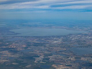
Lake Okeechobee, also known as Florida's Inland Sea, is the largest freshwater lake in the U.S. state of Florida. It is the tenth largest natural freshwater lake among the 50 states of the United States and the second-largest natural freshwater lake contained entirely within the contiguous 48 states.

The Pembina River is a tributary of the Red River of the North, approximately 319 miles (513 km) long, in southern Manitoba in Canada and northeastern North Dakota in the United States. It drains an area of the prairie country along the Canada–US border, threading the Manitoba-North Dakota border eastward to the Red River. Via the Red River, Lake Winnipeg and the Nelson River, it is part of the watershed of Hudson Bay.

The Androscoggin River is a river in the U.S. states of Maine and New Hampshire, in northern New England. It is 178 miles (286 km) long and joins the Kennebec River at Merrymeeting Bay in Maine before its water empties into the Gulf of Maine on the Atlantic Ocean. Its drainage basin is 3,530 square miles (9,100 km2) in area. The name "Androscoggin" comes from the Eastern Abenaki term /aləssíkɑntəkw/ or /alsíkɑntəkw/, meaning "river of cliff rock shelters" ; or perhaps from Penobscot /aləsstkɑtəkʷ/, meaning "river of rock shelters". The Anglicization of the Abenaki term is likely an analogical contamination with the colonial governor Edmund Andros.

Ward Creek is a 6.1-mile (9.8 km) eastward-flowing stream in Placer County, California, United States. The creek flows into Lake Tahoe 2.7 miles (4.3 km) south of Tahoe City, California, and has undergone extensive restoration to reduce sediment and surface run-off to maintain the purity of Lake Tahoe.

The shapefile format is a geospatial vector data format for geographic information system (GIS) software. It is developed and regulated by Esri as a mostly open specification for data interoperability among Esri and other GIS software products. The shapefile format can spatially describe vector features: points, lines, and polygons, representing, for example, water wells, rivers, and lakes. Each item usually has attributes that describe it, such as name or temperature.

ArcGIS is a family of client software, server software, and online geographic information system (GIS) services developed and maintained by Esri. ArcGIS was first released in 1999 and originally was released as ARC/INFO, a command line based GIS system for manipulating data. ARC/INFO was later merged into ArcGIS Desktop, which was eventually superseded by ArcGIS Pro in 2015. ArcGIS Pro works in 2D and 3D for cartography and visualization, and includes Artificial Intelligence (AI).
Lake Apopka is the fourth largest lake in the U.S. state of Florida. It is located 15 miles (24 km) northwest of Orlando, mostly within the bounds of Orange County, although the western part is in Lake County. Fed by a natural spring, rainfall and stormwater runoff, water from Lake Apopka flows through the Apopka-Beauclair Canal and into Lakes Beauclair and Dora. From Lake Dora, water flows into Lake Eustis, then into Lake Griffin and then northward into the Ocklawaha River, which flows into the St. Johns River.

Great East Lake is an 1,825-acre (7.4 km2) water body located in Carroll County, New Hampshire, and York County, Maine, in the United States. The lake is shared by the towns of Wakefield, New Hampshire, and Acton, Maine, with 45% of its surface area in Acton and 55% in Wakefield. The lake is the farthest upstream of the five headwater lakes of the Salmon Falls River, a tributary of the Piscataqua River. Water from Great East Lake flows out its dam and through the 800-foot (240 m) Newichawannock Canal into Horn Pond, then into the Salmon Falls River below Horn Pond.

Lovell Lake is a 538-acre (2.18 km2) water body in Carroll County in eastern New Hampshire, United States, in the town of Wakefield. The lake is both spring-fed and fed by small streams including Horse Brook. The outlet of the lake, located at the village of Sanbornville, is the beginning of the Branch River. From here, the Branch River flows through Milton where it joins the Salmon Falls River on the Maine-New Hampshire border. The Salmon Falls River empties into the tidal waters of the Piscataqua River northwest of Portsmouth, New Hampshire, then into the Gulf of Maine.
ArcGIS Server is the core server geographic information system (GIS) software made by Esri. ArcGIS Server is used for creating and managing GIS Web services, applications, and data. ArcGIS Server is typically deployed on-premises within the organization’s service-oriented architecture (SOA) or off-premises in a cloud computing environment.
Geographic information systems (GISs) have become a useful and important tool in the field of hydrology to study and manage Earth's water resources. Climate change and greater demands on water resources require a more knowledgeable disposition of arguably one of our most vital resources. Because water in its occurrence varies spatially and temporally throughout the hydrologic cycle, its study using GIS is especially practical. Whereas previous GIS systems were mostly static in their geospatial representation of hydrologic features, GIS platforms are becoming increasingly dynamic, narrowing the gap between historical data and current hydrologic reality.

The Trophic State Index (TSI) is a classification system designed to rate water bodies based on the amount of biological productivity they sustain. Although the term "trophic index" is commonly applied to lakes, any surface water body may be indexed.

Geographic Information Systems (GIS) has become an integral part of aquatic science and limnology. Water by its very nature is dynamic. Features associated with water are thus ever-changing. To be able to keep up with these changes, technological advancements have given scientists methods to enhance all aspects of scientific investigation, from satellite tracking of wildlife to computer mapping of habitats. Agencies like the US Geological Survey, US Fish and Wildlife Service as well as other federal and state agencies are utilizing GIS to aid in their conservation efforts.

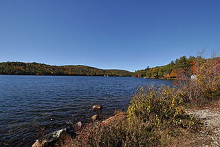
Chocorua Lake is a picturesque lake in northeast New Hampshire with commanding views of the summit of Mount Chocorua. It is approximately 1.1 miles (1.8 km) long (north-south) with a maximum width of 3,500 ft (1.1 km) (east-west), covering 222 acres, and a maximum depth of 27 feet.

Nutrient pollution, a form of water pollution, refers to contamination by excessive inputs of nutrients. It is a primary cause of eutrophication of surface waters, in which excess nutrients, usually nitrogen or phosphorus, stimulate algal growth. Sources of nutrient pollution include surface runoff from farm fields and pastures, discharges from septic tanks and feedlots, and emissions from combustion. Raw sewage is a large contributor to cultural eutrophication since sewage is high in nutrients. Releasing raw sewage into a large water body is referred to as sewage dumping, and still occurs all over the world. Excess reactive nitrogen compounds in the environment are associated with many large-scale environmental concerns. These include eutrophication of surface waters, harmful algal blooms, hypoxia, acid rain, nitrogen saturation in forests, and climate change.
Wilson Lake is a 308 acres (0.5 sq mi) waterbody located in York County, Maine in the United States. The lake is spring-fed and drains to Horn Pond which flows into the Salmon Falls River and eventually empties into the tidal waters of the Piscataqua River in Portsmouth, NH, Great Bay and the Gulf of Maine.
Horn Pond is a 227-acre (92 ha) water body located on the border of Acton, Maine, and Wakefield, New Hampshire, in the United States. The lake is both spring-fed and fed by the outflows of Great East Lake to the north and Wilson Lake to the east. Horn Pond's outlet is the Salmon Falls River which forms a natural border between Maine and New Hampshire and empties into the Piscataqua River east of Dover, New Hampshire, and ultimately the Gulf of Maine.
Aquaveo is a modeling software company based in Provo, Utah that develops software used to model and simulate groundwater, watershed, and surface water resources. Its main software products include SMS, GMS, WMS, and Arc Hydro Groundwater.


