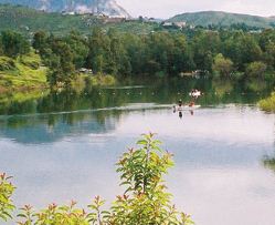
Lake Murray is a reservoir in San Diego, California, operated by the City of San Diego's Public Utilities Department. Although thinly divided by a few housing communities and select roadways, it is technically considered to be part of the jurisdiction which makes up Mission Trails Regional Park. When full, the reservoir covers 171.1 acres (69.2 ha), has a maximum water depth of 95 feet (29 m), and a shoreline of 3.2 miles (5.1 km). The asphalt-paved service road lining roughly two-thirds of the lake's perimeter is a popular recreation site for the Navajo community as well as residents of the northernmost neighborhoods in La Mesa. It lies south of Cowles Mountain and a small golf course. It also functions as an important aeronautical reporting point for aircraft inbound to land at Montgomery-Gibbs Executive Airport.

Bankers Hill, also known as Park West and formerly known as Florence Heights, is a long-established uptown San Diego neighborhood near Balboa Park. It is bordered to the north by Hillcrest at Upas Street, to the south by Downtown, to the east by Balboa Park, and to the west by Interstate 5, Little Italy and the neighborhood known as Midtown. A more constricted definition of the neighborhood sets its eastern boundary as Fourth Avenue and its western boundary as First Avenue.

The Sweetwater River is a 55-mile (89 km) long stream in San Diego County, California.
A. E. "Fred" Coleman was a former slave credited with discovering gold in Julian, California and thus launching a gold rush in that area.
Allied Gardens is a residential neighborhood in the eastern Navajo community of San Diego, California. It neighbors San Carlos to the east, Del Cerro to the south, the College Area to the southeast and Grantville to the southwest.
Westgate Park was a baseball stadium located in San Diego, California. The ballpark was home to the San Diego Padres of the Pacific Coast League from 1958 to 1967.
The Fletcher Hills are a low mountain range in the Peninsular Ranges, in southwestern San Diego County, California.

Lower Otay Reservoir is a reservoir in San Diego County, Southern California. It is flanked by Otay Mountain to the southeast, the Jamul Mountains to the east, Otay Lakes Road and Upper Otay Reservoir to the north, and the city of Chula Vista to the west.
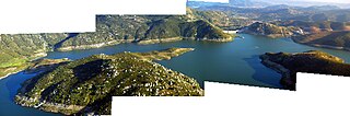
San Vicente Reservoir is a reservoir created by the San Vicente Dam in San Diego County, California. It is located in the Cuyamaca Mountains, approximately 4.3 miles (6.9 km) north of Lakeside off California State Route 67.
Loma Portal is a neighborhood in the community of Point Loma in San Diego, California. It is a hilly area northwest of Rosecrans Street and northeast of Nimitz Boulevard, overlooking San Diego Bay.

The Barona Group of Capitan Grande Band of Mission Indians of the Barona Reservation is a federally recognized tribe of Kumeyaay Indians, who are sometimes known as Mission Indians.

Chollas Creek is an urban creek in San Diego County, California, United States, that drains to the San Diego Bay. It is also referred to as Las Chollas Creek. Chollas Creek arises in Lemon Grove and La Mesa, where its four branches begin. It empties into the Bay at Barrio Logan. The creek is 30 mi (48 km) long. The creek splits into two main forks and may be dry during the Southern California dry season. Multiple plant, animal, and aquatic wildlife species live in or around the creek, including the rare plants Juncus acutus leopoldii and Iva hayesiana, and the threatened Coastal California gnatcatcher.
Palm City is a neighborhood in the southern section of San Diego. Its neighbors are Otay Mesa West to the south and east, Egger Highlands and Nestor to the west, and Chula Vista to the north. It also serves as a gateway to the beach cities of Imperial Beach, and Coronado, by way of the Silver Strand isthmus, due to it being where California State Route 75 meets Interstate 5. Major thoroughfares include Coronado Avenue, Hollister Street, Beyer Boulevard, and Palm Avenue.
Otay Mesa West is a residential neighborhood in the southern section of San Diego. It borders Interstate 805 to the east, Interstate 5 to the west, and California State Route 905 to the south. It neighbors Ocean View Hills to the east, Nestor and Palm City to the west and Chula Vista to the north. The northern boundary of Otay Mesa West roughly coincides with the Otay River. Just north of the Otay River the community of Otay resides within the city of Chula Vista. Major thoroughfares include Palm Avenue, Coronado Avenue, Picador Boulevard, Del Sol Boulevard, Beyer Boulevard, and Beyer Way.

Loveland Dam is a dam across the Sweetwater River in San Diego County, California. The dam forms long, narrow Loveland Reservoir which stores 25,387 acre-feet (31,314,000 m3) of water. It is operated primarily for flood control and municipal water storage in conjunction with downstream Sweetwater Dam but the reservoir is also open to the public for fishing.
Coleman City, also called Emily City, is a ghost town in San Diego County, California. It lies at an elevation of 3601 feet. It is located on State Highway 78 where it crosses Coleman Creek, about four miles west of Julian.

Flinn Springs is an unincorporated community in the East County region of San Diego County, California.
The Tecate Divide is a mountain ridge in southeastern San Diego County, California, running in a north-south direction on the southeast fringe of the Cuyamaca Mountains. It reaches an altitude of 4,239 feet (1,292 m), and passes between the towns of Live Oak Springs to the west and Boulevard, California on its eastern slope.