This page is based on this
Wikipedia article Text is available under the
CC BY-SA 4.0 license; additional terms may apply.
Images, videos and audio are available under their respective licenses.

Lake Ladoga is a freshwater lake located in the Republic of Karelia and Leningrad Oblast in northwestern Russia, in the vicinity of Saint Petersburg.

The Arctic Archipelago, also known as the Canadian Arctic Archipelago, is a group of islands north of the Canadian mainland.
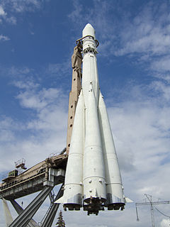
Vostok was a family of rockets derived from the Soviet R-7 Semyorka ICBM and was designed for the human spaceflight programme. This family of rockets launched the first artificial satellite and the first manned spacecraft (Vostok) in human history. It was a subset of the R-7 family of rockets.

The Second Battle of the Masurian Lakes, also known as the Winter Battle of the Masurian Lakes, was the northern part of the Central Powers' offensive on the Eastern Front in the winter of 1915. The offensive was intended to advance beyond the Vistula River and perhaps knock Russia out of the war.
The Nadym is a river in Yamalo-Nenets Autonomous Okrug, Russia. It is a left tributary of the Ob River. The length of the Nadym River is 545 kilometers (339 mi). The area of its basin is 64,000 square kilometers (25,000 sq mi). The river originates in Lake Numto and flows into the Kara Sea. It freezes up in October and stays under the ice until late May. The Levaya Khetta River is one of the biggest tributaries of the Nadym River. The town of Nadym is located on the Nadym River. It is known for having a very rickety pontoon bridge for summer use while winter roads go over the ice. A new fixed bridge for combined road and rail use is to be finished by the end of 2015.

Greater Caucasus is the major mountain range of the Caucasus Mountains.
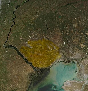
The Ryn Desert or Ryn-Peski Desert, is a desert in western Kazakhstan north of the Caspian Sea and southeast of the Volga Upland. The borders of the desert are very loosely defined. Some maps show the desert almost entirely within the Caspian Depression, stretching almost to the coast of the Caspian Sea, while others show it north of the depression. It lies west of the Ural River between 46° N and 49° N latitude, and 47° E to 52° E longitude. Temperatures can reach extreme highs of 45 to 48 °C during summer and in winter it can drop to a low of −28 to −36 °C.

Cape Crawford is a location in the Northern Territory.
The Lake Naroch Offensive in 1916 was an unsuccessful Russian offensive on the Eastern Front in World War I. It was launched at the request of Marshal Joseph Joffre and intended to relieve the German pressure on French forces. Due to lack of reconnaissance, Russian artillery support failed to overcome and neutralise the well-fortified German defenses and artillery positions, leading to costly and unproductive direct attacks, hindered by the weather. On 30 March General Evert ordered to stop the offensive.

Lake Topozero is a large freshwater lake in the Republic of Karelia, northwestern part of Russia. It is located at around 65.66°N 32°E and has an area of 986 km², it's 75.3 km long and 30.3 km wide. Maximum depth is about 50 m. There are more than 100 islands on the lake. Topozero is used for fishery and timber rafting. From Lake Topozero the waters flow north into the Lake Pyaozero and from there to the White Sea through the Kovda River.

Cayo Sabinal is a cay on the northern coast of Cuba, in the municipality of Nuevitas, Camagüey Province. Has an area of 335 km².

Malas River is a river in Madang Province, Papua New Guinea. It rises in the Adelbert Range and empties to the Bismarck Sea at 4.6666667°S 145.5833333°E.

The North Branch of the Millers River is a river in southwestern New Hampshire and northern Massachusetts in the United States. It is a tributary of the Millers River, which flows west to the Connecticut River, which in turn flows south to Long Island Sound, an arm of the Atlantic Ocean.

Lake Lashaway is a 293-acre (1.19 km2) pond located near the East Brookfield and North Brookfield, Massachusetts town line. The town line cuts the lake approximately in half. The lake lies just to the north of state Route 9 as it passes through East Brookfield.
The East Brookfield River is a 2.4-mile-long (3.9 km) river in Massachusetts that heads at Lake Lashaway in East Brookfield at an elevation of 614 feet (187 m) above sea level. It continues to Quaboag Pond, at an elevation of 594 feet (181 m).

Shokalsky Island is an island in the Kara Sea, in Russia. It is located on the eastern side of the mouth of the Ob River, off the tip of the narrow northwestern arm of the Gydan Peninsula. It is separated from it by a narrow strait full of islets known as Gydanskiy Proliv.

The Yenisei Gulf is a large and long estuary through which the lower Yenisei River flows into the Kara Sea.

WAKI is a radio station licensed to Mcminnville, Tennessee, United States. The station is owned by Peg Broadcasting, LLC.
Novaya is a river in Krasnoyarsk Krai in Russia. It's a left tributary of the Khatanga River. It originates in Lake Gavrila.


