
The geography of Egypt relates to two regions: North Africa and West Asia.
Between 57.3 and 59.5 latitude and 21.5 and 28.1 longitude, Estonia lies on the eastern coast of the Baltic Sea on the level northwestern part of the rising East European Platform. Estonia's continental mainland is bordered to the north by the Gulf of Finland across from Finland, to the east by Lake Peipus and Russia, and to the south by Latvia. Besides the part of the European continent, Estonian territory also includes the larger islands of Saaremaa and Hiiumaa, and over 2,200 other islands and islets in the Baltic Sea, off the western and northern shores of the country's mainland.

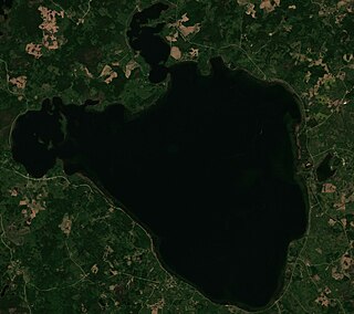
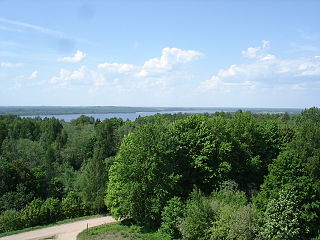
Lake Burtnieks is the fourth largest lake in Latvia. It is shallow with an average depth of 2.9 m. The lake bed is mainly sandy, in places a little muddy. In the southeast part of the lake there is Devonian sandstone rock. The lake has 17 species of fish, such as minnows, salmon, chubs, eels, and pike, and there are areas for duck hunting. The banks are shallow and sandy, but along the southern coast, waves have carved sandstone cliffs. After the regulation of the Salaca river in 1929, the lake level dropped by a metre, and many of the exposed shallows grew covered with reeds and algae. The lake contains three islands with a total area of 14,000 m². The lake lies entirely within the Northern Vidzeme Biosphere Reserve. Small streams from Latvia and Estonia; the Aunupīte, Bauņupīte, Briedes upe, Dūres upe, Ēķinupe, Rūjas upe, and Sedas upe flow into the lake. Lake Burtnieks is the source of 95 km long Salaca river, which flows out of the northwest corner into the Gulf of Riga. In ancient times, the lake was known as Astijärv or Aster, when northern Vidzeme was inhabited by the Livonian people. The lake is a major setting of the Latvian national epic Lāčplēsis, and appears in many Latvian folklore stories. A few small villages cling to the coast today, the largest of which is Burtnieki. The Zvejnieki burial ground is a major archaeological site by the northern shore.

Moosehead Lake is a deep, coldwater lake located in Piscataquis County in Northwestern Maine. It is the largest lake in Maine, second-largest lake in New England, and the largest mountain lake in the eastern United States. Situated in the mostly undeveloped Longfellow Mountains, the lake is the source of the Kennebec River. Several rural Townships border the lake. Greenville is by far the largest town on the lake, with a small downtown area that has banks, shops, and restaurants. There are over 80 islands in the lake, the largest being Sugar Island and Deer Island to the west being the second largest.

Madona is a town with town rights in the Vidzeme region of Latvia and is the center of the Madona municipality.

Governorate of Livonia, also known as Livonia Governorate, was an administrative-territorial unit (guberniya) and one of the Baltic governorates of the Russian Empire, Baltic Governorate-General until 1876. Governorate of Livonia bordered Governorate of Estonia to the north, Saint Petersburg and Pskov Governorates to the east, Courland Governorate to the south, and the Gulf of Riga to the west. In 1897, the population of the governorate was 1,299,365, and it had an area of 47,030.87 square kilometres (18,158.72 sq mi). The administrative centre of the governorate was the Baltic Sea port of Riga. It roughly corresponded to most of the modern Vidzeme Region of Latvia and southern Estonia.
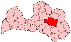
Madona District was an administrative division of Latvia from 1949 to 2009. it was located in the Vidzeme and Latgale regions in the country's east. Within the district is the highest point in Latvia - Gaiziņkalns. The district also bordered Latvia's largest lake, Lake Lubāns.

Lake Engure is a lake in the western part of Latvia, in the Talsi District. It is the third largest lake in the country after Lake Lubāns and Lake Rāzna.

The Aiviekste is a river in Latvia. It begins at Lake Lubāns and drains into the Daugava. The Aiviekste is the largest tributary of the Daugava in Latvia. The Aiviekste, along with the Pededze, forms the unofficial border between two historical Latvian regions Vidzeme and Latgale, although the administrative border was slightly different. The river is 114 kilometers long, with annual drainage 1.81 km³. The Aiviekste is between 10,000 and 12,000 years old, formed at the end of the last ice age. Nearly a quarter of the river's flow is unregulated, but most of the river has been excavated, including with explosions.

Lake Liepāja is the fifth-largest lake in Latvia, located near Liepāja in the Liepāja District. The total area of the lake is 37.15 km2, and it has a length of 16.2 km, average depth of 2.0 m, and a shoreline of 44.6 km.

Belarus is a landlocked, generally flat country without natural borders, that occupies an area of 207,600 square kilometers (80,200 sq mi). Its neighbors are Russia to the east and northeast, Latvia to the north, Lithuania to the northwest, Poland to the west, and Ukraine to the south. Its extension from north to south is 560 km (350 mi), from west to east is 650 km (400 mi).

Madona Municipality is a municipality in Vidzeme, Latvia. The administrative center is Madona.

Smiltene Municipality is a municipality in Vidzeme, Latvia. The municipality was formed in 2009 by merging the town of Smiltene with the rural parishes of Bilska, Blome, Branti, Grundzāle, Launkalne, Palsmane, Smiltene and Variņi. During the 2021 Latvian administrative reform, the previous municipality was merged with Ape Municipality and Rauna Municipality.

The Malta is a river in Latvia. The 105 kilometres long river discharges into the Rēzekne, which in turn feeds Lake Lubāns, the largest lake in the country.

Lake Alūksne is located in Alūksne Municipality, Latvia.
Rāzna is the second largest water surface and the first in terms of water volume lake in Latvia. It is located in the eastern part of the country on the territory of Rēzekne Municipality, the water area of the lake is divided between Kaunatas, Mākoņkalna and Čornajas parishes.
Lake Ciecere is a lake in the southern part of Latvia, near the town of Brocēni in Saldus Municipality, Latvia. The lake has the status of a nature reserve.

Krustkalni Nature Reserve is a nature reserve located in eastern Latvia that was founded in 1977. It has an area of 2,978 hectares. Since 2004, this institution has been part of Natura 2000, a European Union network of protected areas. The reserve is managed by the Latgale regional administration.
Sauka Nature Park is located in Jēkabpils Municipality in Elkšņi, Sauka and Rite parishes in the Selonia region of Latvia. The nature park is located in the highest part, in its territory there are Saukas ezers, Big Lake Klauce, Bukūzis, Aklais Lake, Klauce River and Dūņupe. To the east of Lake Sauka is Ormaņkalns Hill. The nature park acquired the status of national protection in 1987. Area of the territory 54 km 2 .

