The Aare or Aar is the main tributary of the High Rhine and the longest river that both rises and ends entirely within Switzerland.

The geography of Switzerland features a mountainous and landlocked country located in Western and Central Europe. Switzerland's natural landscape is marked by its numerous lakes and mountains. It is surrounded by five countries: Austria and Liechtenstein to the east, France to the west, Italy to the south and Germany to the north. Switzerland has a maximum north–south length of 220 kilometres (140 mi) and an east–west length of about 350 kilometres (220 mi).

Lake Zurich is a lake in Switzerland, extending southeast of the city of Zurich. Depending on the context, Lake Zurich or Zürichsee can be used to describe the lake as a whole, or just that part of the lake downstream of the Hurden peninsula and Seedamm causeway. In the latter case, the upstream part of the lake is called Obersee, whilst the lower part is sometimes also referred to as the Lower Lake, respectively.

Lake Constance refers to three bodies of water on the Rhine at the northern foot of the Alps: Upper Lake Constance (Obersee), Lower Lake Constance (Untersee), and a connecting stretch of the Rhine, called the Seerhein. These waterbodies lie within the Lake Constance Basin in the Alpine Foreland through which the Rhine flows. The nearby Mindelsee is not considered part of Lake Constance. The lake is situated where Germany, Switzerland, and Austria meet. Its shorelines lie in the German states of Baden-Württemberg and Bavaria; the Swiss cantons of St. Gallen, Thurgau, and Schaffhausen; and the Austrian state of Vorarlberg. The actual locations of the country borders within the lake are disputed.

The Rhône is a major river in France and Switzerland, rising in the Alps and flowing west and south through Lake Geneva and Southeastern France before discharging into the Mediterranean Sea. At Arles, near its mouth, the river divides into the Great Rhône and the Little Rhône. The resulting delta forms the Camargue region.

The Engadin or Engadine is a long high Alpine valley region in the eastern Swiss Alps in the canton of Graubünden in southeasternmost Switzerland with about 25,000 inhabitants. It follows the route of the Inn from its headwaters at Maloja Pass in the southwest running roughly northeast until the Inn flows into Austria, little less than one hundred kilometers downstream. The En/Inn subsequently flows at Passau into the Danube, making it the only Swiss river to drain into the Black Sea. The Engadine is protected by high mountain ranges on all sides and is famous for its sunny climate, beautiful landscapes and outdoor activities.

Lake Neuchâtel is a lake primarily in Romandy, the French-speaking part of Switzerland. The lake lies mainly in the canton of Neuchâtel, but is also shared by the cantons of Vaud, Fribourg, and Bern. It comprises one of the lakes in the Three Lakes Region, along with lakes Biel/Bienne and Morat/Murten.
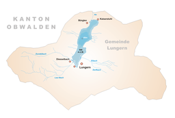
Lungern is a municipality in the canton of Obwalden in Switzerland. It encompasses Lake Lungern and, besides the village of Lungern, the settlements of Bürglen, Kaiserstuhl and Obsee.

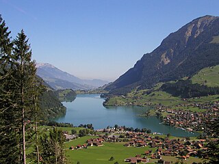
Lake Brienz is a lake just north of the Alps, in the canton of Bern in Switzerland. It has a length of about 14 kilometres (8.7 mi), a width of 2.8 kilometres (1.7 mi) and a maximum depth of 260 metres (850 ft). Its area is 29.8 square kilometres (11.5 sq mi); the surface is 564 metres (1,850 ft) above the sea-level. It is fed, among others, by the upper reaches of the Aare at its eastern end, the Giessbach at its southern shore from steep, forested and rocky hills of the high Faulhorn and Schwarzhoren more than 2,000 metres (6,600 ft) above the lake, as well as by both headwaters of the Lütschine, the Schwarze Lütschine flowing from Grindelwald, and the Weisse Lütschine from the Lauterbrunnen Valley, at its southwestern corner. Not far north from Lütschine's inflow, the lake drains into a further stretch of the Aare at its western end. The culminating point of the lake's drainage basin is the Finsteraarhorn at 4,274 metres above sea level.

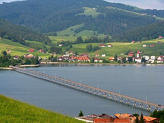
The Brünig railway line is a Swiss narrow gauge railway line that links Lucerne, in central Switzerland, with Interlaken, in the Bernese Oberland. The line runs via Alpnachstad, Giswil, Meiringen and Brienz, and passes over the Brünig Pass, using sections of rack railway to overcome the gradients, but with most of the line operated by normal adhesion methods.

Monte Rosa is a mountain massif in the eastern part of the Pennine Alps, on the border between Italy and Switzerland (Valais). The highest peak of the massif, amongst several peaks of over 4,000 m (13,000 ft), is the Dufourspitze, the second highest mountain in the Alps and western Europe, after Mont Blanc. The east face of the Monte Rosa towards Italy has a height of about 2,400 metres (7,900 ft) and is the highest mountain wall of the Alps.

The Sihl is a Swiss river that rises near the Druesberg mountain in the canton of Schwyz, and eventually flows into the Limmat in the centre of the city of Zürich, after crossing the Zürich–Winterthur railway at Zürich HB. It has a length of 73 km (45 mi), including the Sihlsee reservoir, through which the river flows. Water is abstracted from the river at the Sihlsee, leading to decreased downstream water flows and a consequent reduction in water quality.
The Sihlsee is an artificial lake in the Swiss canton of Schwyz, near the town of Einsiedeln. The lake was created by damming the river Sihl and flooding a section of the upper Sihl Valley.

The Vorderrhein, or Anterior Rhine, is the left of the two initial tributaries of the Rhine. It is longer than the Hinterrhein, but has a lower discharge than the latter at their confluence, which marks the beginning of the Alpine Rhine section.

High Rhine is the name of the part of the Rhine between Lake Constance and the city of Basel, flowing in a general east-to-west direction and forming mostly the Germany–Switzerland border. It is the first of four named sections of the Rhine between Lake Constance and the river delta at the North Sea.

Lake Sarnen is a lake in the Swiss canton of Obwalden. The lake is on the Sarner Aa, which flows out of the Lake Lungern, through the Lake Sarnen, and into Lake Lucerne. The municipalities of Sarnen and Sachseln are located on the shores of the lake, and the Brünig railway line follows the eastern shore.

The Sarner Aa is a 28 km (17 mi) long river in the Swiss canton of Obwalden. It drains the area to the eastern side of the Brünig Pass, flowing through the Lake Lungern, Lake Sarnen and the Wichelsee, before entering Lake Lucerne near Alpnach. It goes by several names over its length, being known as the Lauibach upstream of the Lungerersee, and the Aa or Aawasser between the Lungerersee and Lake Sarnen.

The Brünig Pass, at an altitude of 1,008 m (3,307 ft), connects the Bernese Oberland and central Switzerland, linking Meiringen in the canton of Bern and Lungern in the canton of Obwalden. It is on the watershed between the upper reaches of the Aare, which flows through Lake Brienz and Lake Thun, and the Sarner Aa, which flows into Lake Lucerne.

The A8 motorway, an Autobahn in central Switzerland, is a divided highway connecting the Bernese Oberland and the Innerschweiz. It is part of the National Road N8. For the Canton of Obwalden, it is the lifeline that has allowed the settling of industrial firms in this historically predominantly agricultural region. Via the A8, speedy connections to the major economic centers in the Mittelland and the north–south transit axis A2 are now possible. For tourists, A8 opens up in the opposite direction: the large ski resorts in the Bernese Oberland and the tourism regions around the Brünig Pass and Interlaken.
The Güpfi is a mountain of the Urner Alps, overlooking Lungern in the canton of Obwalden. It lies on the range north of the Chingstuel, between the Lungerersee and the Klein Melchtal.