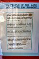
Introduction to the people of the Lake Malawi region (as seen from entrance at the Lake Malawi Museum)
Exhibit of lake birds
Mammals of Lake Malawi area exhibit
History of the Yao people (1)
History of the Yao people (2)
History of the Yao people (3)
History of the Yao people (4)
History of the Yao people (5)
History of the Yao people (6)
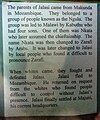
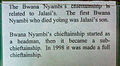
History of the Yao people (7)
History of the Yao people (8)
Exhibit of Stone Age artefacts
Exhibit of Iron Age, clay pots
Exhibit of domestic appliances
Exhibit of Musical Instruments
Mabadza for Mganda dance
Musical rattles
One sided and two sided drum
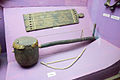
Traditional Yao musical instruments: Kaligo, Bangwe
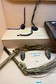
Leg rattles
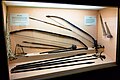
Exhibit of hunting weapons
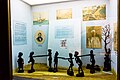
Traditional Games (bawo, mpaka, cards, nsikwa, mdodo, chiwale)
Traditional Games (close up shot of mpaka, cards, nsikwa)
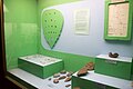
Exhibit of spinning top, nangulungunde
Exhibit showing slaving history
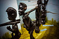
Carving of slave caravan
Carving of slave caravan, alternate
Jumbe and slave trading info
Navigation lights, medical kit, plates, shell from 37mm gun, row locks
Tableware from UMCA
Curios carves from soapstone
Curios carves from soapstone (2)
Pioneer boat
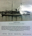
Ilala boat around 1900
Ilala boat around 1875
Charles Janson boat around 1900
Domira boat around 1900
Adventure boat around 1895
Boat exhibit
Hermann Von Wissmann boat around 1900
Dove and other boats from around 1900
Livingstone boat from around 1898
Guendolen boat from around 1902
Chauncy Maples and other boats from around 1910
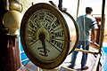
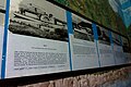
Historical Boats of Lake Malawi