
The Mississippi River is the second-longest river and chief river of the second-largest drainage system on the North American continent, second only to the Hudson Bay drainage system. From its traditional source of Lake Itasca in northern Minnesota, it flows generally south for 2,320 miles (3,730 km) to the Mississippi River Delta in the Gulf of Mexico. With its many tributaries, the Mississippi's watershed drains all or parts of 32 U.S. states and two Canadian provinces between the Rocky and Appalachian mountains. The main stem is entirely within the United States; the total drainage basin is 1,151,000 sq mi (2,980,000 km2), of which only about one percent is in Canada. The Mississippi ranks as the fourth-longest river and fifteenth-largest river by discharge in the world. The river either borders or passes through the states of Minnesota, Wisconsin, Iowa, Illinois, Missouri, Kentucky, Tennessee, Arkansas, Mississippi, and Louisiana.
Sequoia, Sequoya or Sequoyah may refer to:

Sequoyah County is a county located in the U.S. state of Oklahoma. As of the 2010 census, the population was 42,391. The county seat is Sallisaw. Sequoyah County was created in 1907 when Oklahoma became a state. It was named after Sequoyah, who created the Cherokee syllabary and its written language.

Pushmataha County is a county located in the southeastern part of the U.S. state of Oklahoma. As of the 2010 census, the population was 11,572. Its county seat is Antlers.

Scouting in Alabama has a long history, from the 1910s to the present day, serving thousands of youth in programs that suit the environment in which they live.
Scouting in Tennessee has a long history, from the 1910s to the present day, serving thousands of youth in programs that suit the environment in which they live.

Muldrow is a town in Sequoyah County, Oklahoma, United States. It is part of the Fort Smith, Arkansas-Oklahoma Metropolitan Statistical Area. The population was 3,466 at the 2010 census, an increase of 11.7 percent from 3,104 at the 2000 census.

Vonore is a town in Monroe and Blount counties, in the U.S. state of Tennessee. The population was 1,474 as of the 2010 census. The current mayor is Bob Lovingood. The city hall, library, community center, police department, and fire department are located on Church Street.

The Kerr-McGee Corporation, founded in 1929, was an American energy company involved in oil exploration, production of crude oil, natural gas, perchlorate and uranium mining and milling in various countries. On June 23, 2006, Anadarko Petroleum acquired Kerr-McGee in an all-cash transaction totaling $16.5 billion plus $2.6 billion in debt and all operations moved from their base in Oklahoma, United States.

Sequoyah (c.1770–1843), was a Native American polymath of the Cherokee Nation. In 1821 he completed his independent creation of a Cherokee syllabary, making reading and writing in Cherokee possible. This was one of the very few times in recorded history that a member of a pre-literate people created an original, effective writing system. After seeing its worth, the people of the Cherokee Nation rapidly began to use his syllabary and officially adopted it in 1825. Their literacy rate quickly surpassed that of surrounding European-American settlers.
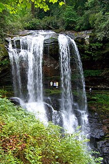
The Cullasaja River is a short river located entirely in Macon County, North Carolina. It is a tributary of the Little Tennessee River, into which it flows near the county seat of Franklin. It originates to the southeast, near Highlands, the county's only other town. It flows from manmade Lake Sequoyah, which is fed by Mirror Lake and other creeks and streams originating on the western side of the Eastern Continental Divide, which runs through the east side of Highlands.

Green Country, sometimes referred to as Northeast Oklahoma, is the northeastern portion of the U.S. state of Oklahoma, which lies west of the northern half of Arkansas, the southwestern corner of Missouri, and south of Kansas.

The Sequoyah Nuclear Plant is a nuclear power plant located on 525 acres (212 ha) located 7 miles (11 km) east of Soddy-Daisy, Tennessee, and 20 miles (32 km) north of Chattanooga, abutting Chickamauga Lake, on the Tennessee River. The facility is owned and operated by the Tennessee Valley Authority (TVA).

Sequoyah High School is a Native American boarding school serving students in grades 7–12, who are members of a federally recognized Native American tribe. The school is located in Park Hill, Oklahoma, near Tahlequah, and is a Bureau of Indian Education (BIE) grant school operated by the Cherokee Nation.

Baldwin is a former unincorporated community in Fayetteville Township, Washington County, Arkansas, United States. It has since been annexed by Fayetteville. It is located in east Fayetteville along Huntsville Road near Lake Sequoyah toward Elkins.
Wyman is an unincorporated community in Wyman Township, Washington County, Arkansas, United States. It is located east of the White River, north of Lake Sequoyah, southwest of Goshen, and east of Fayetteville.

Sequoyah State Park, one of Oklahoma State Park's 32 parks, is a 2,200 acre peninsular recreation space on the eastern shore of Fort Gibson Lake in Cherokee County, Oklahoma. It is 8 miles (13 km) east of Wagoner, Oklahoma and 18 miles (29 km) west of Tahlequah, Oklahoma on State Highway 51. A shortleaf pine-lined drive leads you to the many amenities of the park including camping loops, Paradise Cove Marina, a golf course, Three Forks Nature Center, Sequoyah Riding Stables, and the state's largest state park lodge. The park office is in the town of Hulbert, Oklahoma. There are 12 miles of hiking trails free and open to the public including the Fossil Trail, Bluebird Trail, and Scissortail Paved Trial.
Sequoyah Bay State Park is on the western shore of Fort Gibson Lake in Wagoner County, Oklahoma. It is 4.3 miles (6.9 km) south of Wagoner, Oklahoma on State Highway 16. It offers several campgrounds, each named for a notable chief of the Five Civilized Tribes. These include: Chief Attacullaculla, Cherokee; Chief Pushmataha, Choctaw; Chief Osceola, Seminole; Chief Opothleyahola, Creek; and Chief Payamataha, Chickasaw.
Sequoyah Lake is a reservoir in the U.S. state of Georgia.
Sequoyah Lake or Lake Sequoyah may refer to:

