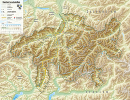
The Grisons or Graubünden, more formally the Canton of the Grisons or the Canton of Graubünden, is one of the twenty-six cantons of Switzerland. It has eleven districts, and its capital is Chur. The German name of the canton, Graubünden, translates as the "Grey Leagues", referring to the canton's origin in three local alliances, the Three Leagues. The other native names also refer to the Grey League: Grischùn in Sutsilvan, Grischun in the other forms of Romansh, and Grigioni in Italian. Rhaetia is the Latin name for the area. The Alpine ibex is the canton's heraldic symbol.

The Inn is a river in Switzerland, Austria and Germany. The 518 km (322 mi) long river is a right tributary of the Danube, being the third largest tributary of the Danube by discharge. The highest point of its drainage basin is the summit of Piz Bernina at 4,049 m (13,284 ft). The Engadine, the valley of the En, is the only Swiss valley whose waters end up in the Black Sea.

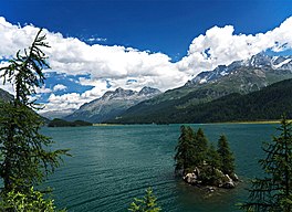
The Engadin or Engadine is a long high Alpine valley region in the eastern Swiss Alps in the canton of Graubünden in southeasternmost Switzerland with about 25,000 inhabitants. It follows the route of the Inn from its headwaters at Maloja Pass in the southwest running roughly northeast until the Inn flows into Austria, little less than one hundred kilometers downstream. The En/Inn subsequently flows at Passau into the Danube, making it the only Swiss river to drain into the Black Sea. The Engadine is protected by high mountain ranges on all sides and is famous for its sunny climate, beautiful landscapes and outdoor activities.

The Julier Pass is a mountain pass in Switzerland, in the Albula Alps. It connects the Engadin valley with central Graubünden, the nearest inhabited localities on its approaches being Silvaplana and Bivio. At its summit, the pass crosses the watershed / drainage divide between the basins of the rivers Rhine and Danube. The Julier Pass lies between Piz Lagrev and Piz Julier. A few metres south of the summit is the small lake Lej da las Culuonnas.

Piz Bernina is the highest mountain in the Eastern Alps, the highest point of the Bernina Range, and the highest peak in the Rhaetian Alps. It rises 4,048 m (13,281 ft) and is located south of Pontresina and near the major Alpine resort of St. Moritz, in the Engadin valley. It is also the most easterly mountain higher than 4,000 m (13,000 ft) in the Alps, the highest point of the Swiss canton of Grisons, and the fifth-most prominent peak in the Alps. Although the summit lies within Switzerland, the massif is on the border with Italy. The "shoulder" known as La Spedla is the highest point in the Italian Lombardy region.

Maloja Pass is a high mountain pass in the Swiss Alps in the canton of Graubünden, linking the Engadine with the Val Bregaglia, still in Switzerland and Chiavenna in Italy. It marks the divide between the Danube and Po watersheds. Lägh da Bitabergh is near the pass.

Silvaplana is a municipality in the Maloja Region in the Swiss canton of Graubünden and the name of a lake in the municipality.

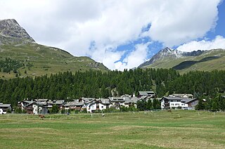
Sils im Engadin/Segl, often also as Sils i.E./Segl, is a municipality and village in the Maloja Region, Upper Engadine in the Swiss canton of the Grisons.
Samedan is a town and municipality in the Maloja Region in the Swiss canton of Grisons. It is served by Samedan railway station on the Rhaetian Railway network and by the Samedan Airport.
Lake Silvaplana is a lake in the Upper-Engadine valley of Grisons, Switzerland. It takes its name from the village of Silvaplana. The lake is also connected to the nearby Lej da Champfèr. Together with its larger neighbour, Lake Sils, it is among the largest lakes of the Grisons. Lake Silvaplana is overlooked by several mountains over 3,000 metres, notably Piz Corvatsch, Piz Julier and Piz Surlej. The lake's drainage basin culminates at Piz Corvatsch and comprises several glaciers, the largest being the Vadret dal Tremoggia.

Lake St. Moritz is a lake at St. Moritz, Switzerland. With a surface of 0.78 km2, it is smaller than the main lakes of the Upper Engadin valley.

Piz da la Margna is a mountain in the Bernina Range of the Alps, overlooking Lake Sils in the Swiss canton of Graubünden. It lies to the south-east of the Maloja Pass at the south-western end of the Engadin valley.

Piz Corvatsch is a mountain in the Bernina Range of the Alps, overlooking Lake Sils and Lake Silvaplana in the Engadin region of the canton of Graubünden. With an elevation of 3,451 m (11,322 ft), it is the highest point on the range separating the main Inn valley from the Val Roseg. Aside from Piz Corvatsch, two other slightly lower summits make up the Corvatsch massif: Piz Murtèl and the unnamed summit where lies the Corvatsch upper cable car station. Politically, the summit of Piz Corvatsch is shared between the municipalities of Sils im Engadin/Segl and Samedan, although the 3,303 m high summit lies between the municipalities of Silvaplana and Samedan. The tripoint between the aforementioned municipalities is the summit of Piz Murtèl.
Champfèr is a village in the Upper Engadin valley of the canton of Graubünden, Switzerland. The Western part of the village belongs to the municipality of Silvaplana and part of the village belongs to the municipality of St. Moritz. The two halves of the town are separated by the creek Ova da Suvretta.

Chaviolas is an island in Lake Sils, located in the canton of Graubünden. It is the largest island in Lake Sils, the second largest being located 100 metres west. The island has a maximum length of 120 metres and a maximum width of 55 metres and includes a 40-metre (130-foot) triangular bay on its northern side. Its highest point is 1,809 metres above sea level or 12 metres above lake level, making it among the highest islands in Switzerland and in the Alps. Its surface is entirely wooded. The island lies in the bay south of the peninsula of Chastè, about 200 metres from the shore.
The Engadin Skimarathon is an annual cross-country skiing race held on the second Sunday of March in the upper Engadine valley (Switzerland), between Maloja and S-chanf. It debuted in 1969 and has been a part of Worldloppet as long as Worldloppet has existed. It is one of the major cross-country skiing events in the Alps. Between 11,000 and 14,200 skiers participate each year. The total distance covered is 42 km, although it is also possible to complete the half-marathon of 21 km or the 17 km Women's Race. While it is a freestyle race, there are separate tracks for skiers practicing classic style for all but the narrowest parts of the race. Participation is open to anyone from the age of 16, and no licence is required to sign up.

The Val Roseg is a valley of the Swiss Alps, located on the north side of the Bernina Range in the canton of Graubünden (Engadin). The valley is drained by the Ova da Roseg, a tributary of the Flaz, at Pontresina. Most of the valley is part of an exclave of the municipality of Samedan. Only the bottom of Val Roseg lies in the municipality of Pontresina.

Val Fex is a southern side valley from the Upper Engadine in Switzerland, located at an altitude of around 1,800 to 2,000 metres above sea level. It belongs to the municipality of Sils im Engadin/Segl.
The Engadine Line is an over 50 kilometres (30 mi) long strike-slip fault in the Swiss canton of Graubünden, which extends into Italy and Austria. It runs along the Engadine Valley and the Bregaglia Valley and offsets Austroalpine and Penninic units in a sinistral direction. The western end of the fault appears to peter out into ductile deformation in the Bregaglia Valley or continues as the Gruf Line to the southwest; the eastern end is buried by the Ötztal tectonic block and may continue as the "Inntal fault", "Isar fault" or "Loisach fault".

The Maloja Wind is a Foehn-type mountain wind that occurs in the upper Engadin, an alpine valley located in Switzerland. The wind blows up-valley during the nighttime and down-valley during the day, a deviation of the typical direction of mountain and valley winds. The phenomenon is caused by wind from the Val Bregaglia crossing the Maloja Pass and intruding into the Engadin. The Maloja Wind occasionally produces a weather phenomenon known as the Maloja Snake, a low-lying cloud so named for its long, serpentine shape.