
The Mississippi River is the second-longest river and chief river of the second-largest drainage system in North America, second only to the Hudson Bay drainage system. From its traditional source of Lake Itasca in northern Minnesota, it flows generally south for 2,340 miles (3,770 km) to the Mississippi River Delta in the Gulf of Mexico. With its many tributaries, the Mississippi's watershed drains all or parts of 32 U.S. states and two Canadian provinces between the Rocky and Appalachian mountains. The main stem is entirely within the United States; the total drainage basin is 1,151,000 sq mi (2,980,000 km2), of which only about one percent is in Canada. The Mississippi ranks as the thirteenth-largest river by discharge in the world. The river either borders or passes through the states of Minnesota, Wisconsin, Iowa, Illinois, Missouri, Kentucky, Tennessee, Arkansas, Mississippi, and Louisiana.

The Missouri River is the longest river in the United States. Rising in the Rocky Mountains of the Eastern Centennial Mountains of Southwestern Montana, the Missouri flows east and south for 2,341 miles (3,767 km) before entering the Mississippi River north of St. Louis, Missouri. The river drains a sparsely populated, semi-arid watershed of more than 500,000 square miles (1,300,000 km2), which includes parts of ten U.S. states and two Canadian provinces. Although a tributary of the Mississippi, the Missouri River is much longer and carries a comparable volume of water. When combined with the lower Mississippi River, it forms the world's fourth longest river system.

The Allegheny River is a 325 mi (523 km) long headwater stream of the Ohio River in western Pennsylvania and New York. The Allegheny River runs from its headwaters just below the middle of Pennsylvania's northern border northwesterly into New York then in a zigzag southwesterly across the border and through Western Pennsylvania to join the Monongahela River at the Forks of the Ohio at Point State Park in Downtown Pittsburgh, Pennsylvania. The Allegheny River is, by volume, the main headstream of both the Ohio and Mississippi Rivers. Historically, the Allegheny was considered to be the upper Ohio River by both Native Americans and European settlers.

Kentwood is a rural town in Tangipahoa Parish, Louisiana, United States, near the Mississippi state line. The population was 2,198 at the 2010 census. It is part of the Hammond Micropolitan Statistical Area. Kentwood is best known as the hometown of singer Britney Spears.

Lake Pontchartrain is an estuary located in southeastern Louisiana in the United States. It covers an area of 630 square miles (1,600 km2) with an average depth of 12 to 14 feet. Some shipping channels are kept deeper through dredging. It is roughly oval in shape, about 40 miles (64 km) from west to east and 24 miles (39 km) from south to north.

The Souris River or Mouse River is a river in central North America. It is about 700 km (430 mi) in length and drains about 23,600 square miles (61,100 km2). It rises in the Yellow Grass Marshes north of Weyburn, Saskatchewan. It wanders south through North Dakota beyond Minot to its most southern point at the city of Velva, and then back north into Manitoba. The river passes through the communities of Melita, Hartney, Souris and Wawanesa and on to its confluence with the Assiniboine River near Treesbank, about 25 miles (40 km) southeast of Brandon. The main tributaries which flow into the Souris in Manitoba are the Antler River, the Gainsborough, and Plum Creeks.
Glacial Lake Wisconsin was a prehistoric proglacial lake that existed from approximately 18,000 to 14,000 years ago, at the end of the last ice age, in the central part of present-day Wisconsin in the United States.
The Driftless Area, a topographical and cultural region in the American Midwest, comprises southwestern Wisconsin, southeastern Minnesota, northeastern Iowa, and the extreme northwestern corner of Illinois.

Legion State Park is public recreation area located on the north edge of the city of Louisville, Mississippi, and adjacent to Tombigbee National Forest. As Legion State Park Historic District, the state park entered the National Register of Historic Places in 1998. It is managed by the Mississippi Department of Wildlife, Fisheries and Parks.
Drainage in New Orleans, Louisiana, has been a major concern since the founding of the city in the early 18th century, remaining an important factor in the history of New Orleans today. The central portion of metropolitan New Orleans is fairly unusual in that it is almost completely surrounded by water: Lake Pontchartrain to the north, Lake Borgne to the east, wetlands to the east and west, and the Mississippi River to the south. Half of the land area between these bodies of water is at or below sea level, and no longer has a natural outlet for flowing surface water. As such, virtually all rainfall occurring within this area must be removed through either evapotranspiration or pumping. Thus, flood threats to metropolitan New Orleans include the Mississippi River, Lake Pontchartrain, canals throughout the city, and natural rainfall. Artificial levees have been built to keep out rising river and lake waters but have had the negative effect of keeping rainfall in, and have failed on numerous occasions.

Tombigbee State Park is a public recreation area located off Mississippi Highway 6 approximately 5 miles (8.0 km) east of Tupelo, Mississippi. The state park surrounds 90-acre (36 ha) Lake Lee and is named for the nearby Tombigbee River.

Percy Quin State Park is a public recreation area located off Interstate 55, approximately 7 miles (11 km) southwest of McComb, Mississippi. The state park surrounds 490-acre (200 ha) Lake Tangipahoa, an impoundment of the Tangipahoa River.

The Raccoon River is a 30.8-mile-long (49.6 km) tributary of the Des Moines River in central Iowa in the United States. As measured using the longest of its three forks, its length increases to 226 miles (364 km). Via the Des Moines River, it is part of the watershed of the Mississippi River. The river runs through an intensely cultivated area of croplands and livestock farming, receiving Tile drainage from slow-draining rich natural bottomland.

The Mississippi National River and Recreation Area is a 72-mile (116 km) and 54,000-acre (22,000 ha) protected corridor along the Mississippi River through the Minneapolis–Saint Paul metro in the U.S. state of Minnesota, from the cities of Dayton and Ramsey, to just downstream of Hastings. This stretch of the upper Mississippi River includes natural, historical, recreational, cultural, scenic, scientific, and economic resources of national significance. This area is the only national park site dedicated exclusively to the Mississippi River. The Mississippi National River and Recreation Area is sometimes abbreviated as MNRRA or MISS, the four letter code assigned to the area by the National Park Service. The Mississippi National River and Recreation Area is classified as one of four national rivers in the United States, and despite its name it is technically not one of the 40 national recreation areas.

The Presumpscot River is a 25.8-mile-long (41.5 km) river located in Cumberland County, Maine. It is the main outlet of Sebago Lake. The river provided an early transportation corridor with reliable water power for industrial development of the city of Westbrook and the village of South Windham.
Floods in the United States before 1900 is a list of flood events that were of significant impact to the country, before 1900. Floods are generally caused by excessive rainfall, excessive snowmelt, and dam failure.
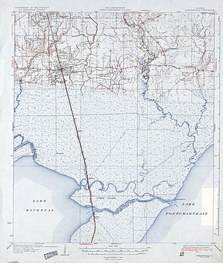
The Tangipahoa River originates northwest of McComb in southwest Mississippi, and runs south 122 miles (196 km) through Lake Tangipahoa in Percy Quin State Park before passing into southeast Louisiana. There it flows entirely in the eponymous Tangipahoa Parish until its mouth opens into the northwest region of Lake Pontchartrain.

Hurricane Isaac was a deadly and destructive tropical cyclone that came ashore in the U.S. state of Louisiana during August 2012. The ninth named storm and fourth hurricane of the annual hurricane season, Isaac originated from a tropical wave that moved off the west coast of Africa on August 16. Tracking generally west, a broad area of low pressure developed along the wave axis the next day, and the disturbance developed into a tropical depression early on August 21 while several hundred miles east of the Lesser Antilles. The system intensified into a tropical storm shortly thereafter, but high wind shear initially prevented much change in strength.
The effects of Hurricane Isaac in Louisiana were more severe than anywhere in the storm's path, and included $611.8615 million in damages and five total deaths. Forming from a tropical wave in the central Atlantic, Isaac traversed across many of the Lesser and Greater Antilles, before reaching peak intensity with winds of 80 mph (130 km/h) on August 28, 2012 while in the Gulf of Mexico. Nearing the coast of Louisiana, the Category 1 hurricane slowly moved towards the west, making two landfalls in the state with little change of intensity prior to moving inland for a final time. The hurricane weakened and later dissipated on September 1 while over Missouri. Before landfall, Governor Bobby Jindal declared a state of emergency to the state, as well as ordering the mandatory evacuation of 60,000 residents in low-lying areas of Louisiana along the Tangipahoa River in Tangipahoa Parish.

