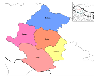
Rapti Zone was one of the fourteen zones, located in the Mid-Western Development Region of Nepal. It was named after the West Rapti River which drains Rolpa, Pyuthan and part of Dang districts. The remainder of Dang and part of Salyan district are drained by the Babai. The remainder of Salyan and all of Rukum districts are drained by the Bheri.

Banke District (Nepali: बाँके जिल्ला [bãke], a part of Lumbini Province, is one of the 77 districts of Nepal. The district, located in midwestern Nepal with Nepalganj as its district headquarters, covers an area of 2,337 km2 and had a population of 385,840 in 2001 and 491,313 in 2011. There are three main cities in the Banke District: Nepalganj, Kohalpur and Khajura Bajaar.

Bardiya District, one of the seventy-seven Districts of Nepal, is part of Lumbini Province of Nepal. The district, with Gulariya as its headquarters, covers an area of 2,025 km2 (782 sq mi) and according to the 2001 census the population was 382,649 in 2011 it has 426,576.

Dang District(Nepali: दाङ जिल्ला [daŋ]) is located in Inner Terai in Lumbini Province in midwestern Nepal. The district, with Ghorahi as its headquarters, covers 2,955 km² and has a population (2011) of 548,141. Tulsipur, the second biggest city of Dang, is a transportation hub. There are numerous temples and gumbas in Dang Deukhuri district.

Rukum District was a "hill" and "mountain" district some 280 km (170 mi) west of Kathmandu partially belonging to Province No. 5 and partially to Karnali Pradesh before split into two districts Western Rukum and Eastern Rukum after the state's reconstruction of administrative divisions in 2017. Rukum covers an area of 2,877 km2 (1,111 sq mi) with population of 207,290 in 2011 Nepal census. Musikot was the district's administrative center.

RolpaListen (help·info), is a "hill" district in Lumbini Province of Nepal. Rolpa district covers an area of 1,879 km2 (725 sq mi) with population (2011) of 221,177. Rolpa town is the district's administrative center.
Kot Bhairab is a village in Bajhang District in the Seti Zone of north-western Nepal. At the time of the 1991 Nepal census it had a population of 2,734 and had 506 houses in the village.
Lekhgaun is a village in Bajhang District in the Seti Zone of north-western Nepal. At the time of the 1991 Nepal census it had a population of 3,346 and had 626 houses in the village.
Udayapur is a Village Development Committee in Banke District in Lumbini Pradesh of south-western Nepal. At the time of the 1991 Nepal census it had a population of 2,301 and had 397 houses in the village. Two government owned primary schools are situated here along with one among 10 Health Posts in district and a Police station. Now, it is a part of Nepalgunj sub-metropolitan city.
Tandrang is a Village Development Committee in Gorkha District in the Gandaki Zone of northern-central Nepal. At the time of the 1991 Nepal census it had a population of 4,368 and had 838 houses in the town.
Khopasi is a village development committee in Kabhrepalanchok District in the Bagmati Zone of central Nepal. At the time of the 1991 Nepal census it had a population of 3453 in 676 individual households.
Amritpur is a village and former Village Development Committee that is now part of Tulsipur Sub-Metropolitan City in Dang Deokhuri District in Province No. 5 of south-western Nepal. At the time of the 1991 Nepal census it had a population of 9,680 persons living in 1725 individual households.
Kabhre is a town and Village Development Committee in Dang Deokhuri District in Province No. 5 of south-western Nepal. At the time of the 1991 Nepal census it had a population of 6,033 persons residing in 1142 individual households.
Lalmitiya is a town and Village Development Committee in Dang Deokhuri District in Province No. 5 of south-western Nepal. At the time of the 1991 Nepal census it had a population of 12,048 persons living in 1900 individual households.
Manpur is a town and Village Development Committee in Dang Deokhuri District in Province No. 5 of south-western Nepal. At the time of the 1991 Nepal census it had a population of 9,960 persons residing in 1449 individual households.
Pawan Nagar is a town and Village Development Committee in Dang District in Lumbini Province of south-western Nepal. At the time of the 1991 Nepal census it had a population of 11,428 persons living in 1961 individual households. Farming is the main occupation.
Rajpur is a town and Village Development Committee in Dang Deokhuri District in Province No. 5 of south-western Nepal. At the time of the 1991 Nepal census it had a population of 8,811 persons residing in 1454 individual households.
Marmaparikhanda is a village development committee in Salyan District in the Rapti Zone of western-central Nepal. At the time of the 1991 Nepal census it had a population of 3530 people living in 597 individual households.
Rangsi is a village development committee in Rolpa District in the Rapti Zone of north-eastern Nepal. At the time of the 1991 Nepal census it had a population of 4000 people living in 745 individual households.
Goltakuri is a Village Development Committee (VDC) of Dang district, Province No. 5, Nepal. It is situated below the Churya Range Hill from the south, Tui-Soto from the east, the Babai River from the north. It has a population of 5,293 among 2,411 are male and 2,882 are female. The household is 1,119 in number. According to population census of 2011, it is the third least populated VDC among the 2 Municipalities and 39 VDCs of Dang district.
