Lalinovac

Last updated
Lalinovac
Village
Serbia adm location map.svg
Red pog.svg
Lalinovac
Coordinates: 42°55′12″N21°38′30″E / 42.92000°N 21.64167°E / 42.92000; 21.64167
CountryFlag of Serbia.svg  Serbia
District Jablanica District
Municipality Lebane
Population (2002)
  Total 250
Time zone CET (UTC+1)
  Summer (DST) CEST (UTC+2)

Lalinovac is a village in the municipality of Lebane, Serbia. According to the 2002 census, the village has a population of 250 people. [1]

Village Small clustered human settlement smaller than a town

A village is a clustered human settlement or community, larger than a hamlet but smaller than a town, with a population ranging from a few hundred to a few thousand. Though villages are often located in rural areas, the term urban village is also applied to certain urban neighborhoods. Villages are normally permanent, with fixed dwellings; however, transient villages can occur. Further, the dwellings of a village are fairly close to one another, not scattered broadly over the landscape, as a dispersed settlement.

Lebane Town and municipality in Southern and Eastern Serbia, Serbia

Lebane is a town and municipality located in Jablanica District of southern Serbia. According to the 2011 census, the town has a population of 10,062 inhabitants, while the municipality has 20,000 inhabitants.

Serbia Republic in Southeastern Europe

Serbia, officially the Republic of Serbia, is a country situated at the crossroads of Central and Southeast Europe in the southern Pannonian Plain and the central Balkans. The sovereign state borders Hungary to the north, Romania to the northeast, Bulgaria to the southeast, North Macedonia to the south, Croatia and Bosnia and Herzegovina to the west, and Montenegro to the southwest. The country claims a border with Albania through the disputed territory of Kosovo. Serbia's population is about seven million. Its capital, Belgrade, ranks among the oldest and largest citiеs in southeastern Europe.

Related Research Articles

Dolní Ředice Village in Pardubice District of Pardubice region

Dolní Ředice is a village in the Pardubice Region of the Czech Republic, near the town of Holice. It has around 790 inhabitants.

Svinčany Village in Pardubice District of Pardubice region

Svinčany is a village in the Pardubice Region of the Czech Republic. It has around 370 inhabitants.

Podhorie, Žilina District municipality of Slovakia

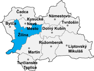
Podhorie is a village and municipality in Žilina District in the Žilina Region of northern Slovakia.

Kravany, Trebišov District municipality of Slovakia in Trebišov District

Kravany is a village and municipality in the Trebišov District in the Košice Region of eastern Slovakia.

Barat, also Bharat or Bhart, is a village in Bannu District of Khyber Pakhtunkhwa, Pakistan.

Nucșoara is a commune in Argeș County, in southern central Romania. It is composed of four villages: Gruiu, Nucșoara, Sboghițești and Slatina.

Kobusy, Podlaskie Voivodeship Village in Podlaskie, Poland

Kobusy is a village in the administrative district of Gmina Ciechanowiec, within Wysokie Mazowieckie County, Podlaskie Voivodeship, in north-eastern Poland. The village has a population of 110. It lies approximately 10 kilometres (6 mi) east of Ciechanowiec, 27 km (17 mi) south of Wysokie Mazowieckie, and 60 km (37 mi) south-west of the regional capital Białystok.

Bożęcin, Świętokrzyskie Voivodeship Village in Świętokrzyskie, Poland

Bożęcin is a village in the administrative district of Gmina Wilczyce, within Sandomierz County, Świętokrzyskie Voivodeship, in south-central Poland. It lies approximately 5 kilometres (3 mi) north of Wilczyce, 14 km (9 mi) north-west of Sandomierz, and 73 km (45 mi) east of the regional capital Kielce.

Starogród, Masovian Voivodeship Village in Masovian, Poland

Starogród is a village in the administrative district of Gmina Siennica, within Mińsk County, Masovian Voivodeship, in east-central Poland. It lies approximately 18 kilometres (11 mi) south of Mińsk Mazowiecki and 49 km (30 mi) south-east of Warsaw.

Łęg Starościński Village in Masovian, Poland

Łęg Starościński is a village in the administrative district of Gmina Lelis, within Ostrołęka County, Masovian Voivodeship, in east-central Poland. It lies approximately 8 kilometres (5 mi) south-east of Lelis, 10 km (6 mi) north-east of Ostrołęka, and 111 km (69 mi) north-east of Warsaw.

Kluczewnica is a village in the administrative district of Gmina Słupca, within Słupca County, Greater Poland Voivodeship, in west-central Poland.

Moszczenica, Pomeranian Voivodeship Village in Pomeranian, Poland

Moszczenica is a village in the administrative district of Gmina Chojnice, within Chojnice County, Pomeranian Voivodeship, in northern Poland. It lies approximately 8 kilometres (5 mi) south-west of Chojnice and 110 km (68 mi) south-west of the regional capital Gdańsk.

Rzuski Las Village in Pomeranian, Poland

Rzuski Las is a village in the administrative district of Gmina Główczyce, within Słupsk County, Pomeranian Voivodeship, in northern Poland. It lies approximately 5 kilometres (3 mi) north-east of Główczyce, 33 km (21 mi) north-east of Słupsk, and 84 km (52 mi) west of the regional capital Gdańsk.

Cichogrąd is a village in the administrative district of Gmina Olsztynek, within Olsztyn County, Warmian-Masurian Voivodeship, in northern Poland.

Zichovec Municipality and village in Central Bohemian Region, Czech Republic

Zichovec is a village and municipality in Kladno District in the Central Bohemian Region of the Czech Republic.

Pine Hill, New York is a hamlet in the town of Cheektowaga in Erie County, New York, United States.

Bagdad is a hamlet in the town of Collins in Erie County, New York, United States.

Kozilo Village in Jablanica District, Serbia

Kozilo is a village in the municipality of Vlasotince, Serbia. According to the 2002 census, the village has a population of 8 people.

Davidovac is a village in the municipality of Kladovo, Serbia. According to the 2002 census, the village has a population of 610 people.

Hlinaia, Slobozia, Transnistria Village in Moldova

Hlinaia is a village in the Slobozia District of Transnistria, Moldova. It is currently under the administration of the breakaway government of the Transnistrian Moldovan Republic.

References

  1. Popis stanovništva, domaćinstava i Stanova 2002. Knjiga 1: Nacionalna ili etnička pripadnost po naseljima. Republika Srbija, Republički zavod za statistiku Beograd 2003. ISBN   86-84433-00-9

Coordinates: 42°55′12″N21°38′30″E / 42.92000°N 21.64167°E / 42.92000; 21.64167

Geographic coordinate system Coordinate system

A geographic coordinate system is a coordinate system that enables every location on Earth to be specified by a set of numbers, letters or symbols. The coordinates are often chosen such that one of the numbers represents a vertical position and two or three of the numbers represent a horizontal position; alternatively, a geographic position may be expressed in a combined three-dimensional Cartesian vector. A common choice of coordinates is latitude, longitude and elevation. To specify a location on a plane requires a map projection.