
Cape Cod is a hook-shaped peninsula extending into the Atlantic Ocean from the southeastern corner of Massachusetts, in the northeastern United States. Its historic, maritime character and ample beaches attract heavy tourism during the summer months. The name Cape Cod, coined in 1602 by Bartholomew Gosnold, is the ninth oldest English place-name in the U.S.
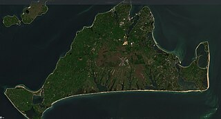
Martha's Vineyard, often simply called the Vineyard, is an island in the Northeastern United States, located south of Cape Cod in Dukes County, Massachusetts, known for being a popular, affluent summer colony. Martha's Vineyard includes the smaller adjacent Chappaquiddick Island, which is usually connected to the Vineyard. The two islands have sometimes been separated by storms and hurricanes, which last occurred from 2007 to 2015. It is the 58th largest island in the U.S., with a land area of about 96 square miles (250 km2), and the third-largest on the East Coast, after Long Island and Mount Desert Island. Martha's Vineyard constitutes the bulk of Dukes County, which also includes the Elizabeth Islands and the island of Nomans Land.
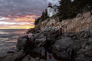
Acadia National Park is an American national park located along the mid-section of the Maine coast, southwest of Bar Harbor. The park preserves about half of Mount Desert Island, part of the Isle au Haut, the tip of the Schoodic Peninsula, and portions of 16 smaller outlying islands. It protects the natural beauty of the rocky headlands, including the highest mountains along the Atlantic coast. Acadia boasts a glaciated coastal and island landscape, an abundance of habitats, a high level of biodiversity, clean air and water, and a rich cultural heritage.

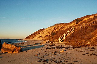
Aquinnah is a town located on the western end of Martha's Vineyard island, Massachusetts. From 1870 to 1997, the town was incorporated as Gay Head. At the 2020 U.S. census, the population was 439. Aquinnah is known for its beautiful clay cliffs and natural serenity, as well as its historical importance to the native Wampanoag people. In 1965, Gay Head Cliffs were designated as a National Natural Landmark by the National Park Service.
Chilmark is a town located on Martha's Vineyard in Dukes County, Massachusetts, United States. The population was 1,212 at the 2020 census. The fishing village of Menemsha is located on the western side of the town along its border with the town of Aquinnah. Chilmark had the highest median home sale price of any town or city in Massachusetts in 2013.
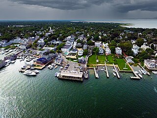
Edgartown is a town on the island of Martha's Vineyard in Dukes County, Massachusetts, United States, for which it is the county seat. The town's population was 5,168 at the 2020 census.

Oak Bluffs is a town located on the island of Martha's Vineyard in Dukes County, Massachusetts, United States. The population was 5,341 at the 2020 United States Census. It is one of the island's principal points of arrival for summer tourists, and is noted for its "gingerbread cottages" and other well-preserved mid- to late-nineteenth-century buildings. The town has been a historically important center of African American culture since the eighteenth century.
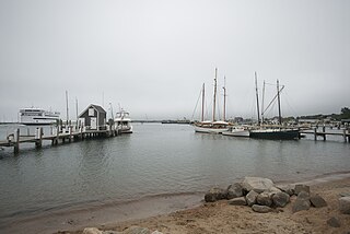
Tisbury is a town located on Martha's Vineyard in Dukes County, Massachusetts, United States. The population was 4,815 at the 2020 census.

West Tisbury is a town located on Martha's Vineyard in Dukes County, Massachusetts, United States. The population was 3,555 at the 2020 census. Along with Chilmark and Aquinnah, West Tisbury forms "Up-Island" Martha's Vineyard.
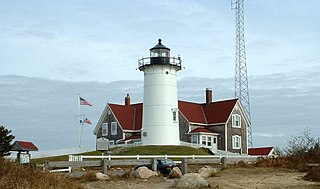
Falmouth is a town in Barnstable County, Massachusetts, United States. The population was 32,517 at the 2020 census, making Falmouth the second-largest municipality on Cape Cod after Barnstable. The terminal for the Steamship Authority ferries to Martha's Vineyard is located in the village of Woods Hole in Falmouth. Woods Hole also contains several scientific organizations such as the Woods Hole Oceanographic Institution (WHOI), the Marine Biological Laboratory (MBL), the Woodwell Climate Research Center, NOAA's Woods Hole Science Aquarium, and the scientific institutions' various museums.

Chappaquiddick Island, a part of the town of Edgartown, Massachusetts, is a small island off the eastern end of Martha's Vineyard. Norton Point, a narrow barrier beach, sometimes connects Martha's Vineyard and Chappaquiddick between Katama and Wasque. Breaches occur due to hurricanes and strong storms separating the islands for periods of time, most recently on December 22, 2022. While both land forms have mostly been connected to one another in modern history, Chappaquiddick is nevertheless referred to as an island.

The North Shore of Long Island is the area along the northern coast of New York's Long Island bordering Long Island Sound. Known for its extreme wealth and lavish estates, the North Shore exploded into affluence at the turn of the 20th century, earning it the nickname the Gold Coast. Historically, this term refers to the affluent coastline neighborhoods of the towns of North Hempstead and Oyster Bay in Nassau County and Huntington in Suffolk County. Some definitions may also include the parts of Smithtown that face the Sound. The region is also largely coextensive with the Gold Coast region of Long Island, though this region excludes Smithtown, as the easternmost Gold Coast mansion is the Geissler Estate, located just west of Indian Hills Country Club in the Fort Salonga section of Huntington.

The Driftless Area, also known as Bluff Country, the Blufflands, the Paleozoic Plateau, and the Coulee Region, is a topographical and cultural region in the Midwestern United States that comprises southwestern Wisconsin, southeastern Minnesota, northeastern Iowa, and the extreme northwestern corner of Illinois. The Driftless Area is a USDA Level III Ecoregion: Ecoregion 52. The Driftless Area takes up a large portion of the Upper Midwest forest–savanna transition.
Makonikey is a rural neighborhood on Martha's Vineyard, Massachusetts, that lies on the border of Tisbury and West Tisbury. The Tisbury section is called Lower Makonikey, and the West Tisbury section is called Upper Makonikey. The neighborhood lies between Lambert's Cove Road and the Vineyard Sound, near Makonikey Point. It is a 5- to 10-minute drive from the center of Vineyard Haven.

The Tiasquam River is a 3.7-mile-long (6.0 km) stream on the southwest of Martha's Vineyard, Massachusetts.

Lambert's Cove Beach is a well-known beach in the town of West Tisbury on the island of Martha's Vineyard in Massachusetts, United States. The beach is located off Lambert's Cove Road and is situated in a cove off of Vineyard Sound facing west towards the Elizabeth Islands. It is known chiefly for the beauty of the beach and the setting, which recalls a Caribbean cove.

Marstons Mills is a village in the town of Barnstable, Massachusetts, United States. It is primarily residential, located on Massachusetts Route 28, and rural in nature. Main roads also include Massachusetts Route 149, Race Lane, River Road, Osterville-West Barnstable Road, and Santuit-Newtown Road.

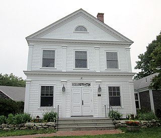
The Old Mill is an historic mill building at 690 Edgartown-West Tisbury Road in West Tisbury, Massachusetts, on the island of Martha's Vineyard. The current structure was built c. 1848, and occupies a site that has seen industrial use since the 17th century. The property is currently owned by the Martha's Vineyard Garden Club.

Martha's Vineyard Transit Authority(VTA) is a bus transportation system serving Martha's Vineyard, Massachusetts. In addition to diesel buses, it has 12 electric buses charged at several points. The Edgartown facility has 700 kW solar panels and a 1.5 MWh battery adding to the bus power.

Route 204, also known as Southwest Arm Road, is a 30.5-kilometre-long (19.0 mi) east–west highway on the island of Newfoundland in the province of Newfoundland and Labrador. It connects the communities along the southern shore of the Southwest Arm of Trinity Bay with the Trans-Canada Highway at North West Brook. It is a very curvy two-lane highway traversing very hilly terrain for its entire length.
