Makonikey is a rural neighborhood on Martha's Vineyard, Massachusetts, that lies on the border of Tisbury (also known as Vineyard Haven) and West Tisbury. The Tisbury section is called Lower Makonikey, and the West Tisbury section is called Upper Makonikey. The neighborhood lies between Lambert's Cove Road and the Vineyard Sound, near Makonikey Point. It is a 5- to 10-minute drive from the center of Vineyard Haven.
Martha's Vineyard is an island located south of Cape Cod in Massachusetts that is known for being an affluent summer colony. Martha's Vineyard includes the smaller Chappaquiddick Island, which is usually connected to the Vineyard, though storms and hurricanes have separated them, as in 2007. It is the 58th largest island in the United States, with a land area of about 96 square miles (250 km2), and the third-largest on the East Coast of the United States, after Long Island and Mount Desert Island. Martha's Vineyard constitutes the bulk of Dukes County, Massachusetts, which also includes the Elizabeth Islands and the island of Nomans Land.
Massachusetts, officially the Commonwealth of Massachusetts, is the most populous state in the New England region of the northeastern United States. It borders on the Atlantic Ocean to the east, the states of Connecticut and Rhode Island to the south, New Hampshire and Vermont to the north, and New York to the west. The state is named after the Massachusett tribe, which once inhabited the east side of the area, and is one of the original thirteen states. The capital of Massachusetts is Boston, which is also the most populous city in New England. Over 80% of Massachusetts's population lives in the Greater Boston metropolitan area, a region influential upon American history, academia, and industry. Originally dependent on agriculture, fishing and trade, Massachusetts was transformed into a manufacturing center during the Industrial Revolution. During the 20th century, Massachusetts's economy shifted from manufacturing to services. Modern Massachusetts is a global leader in biotechnology, engineering, higher education, finance, and maritime trade.
Tisbury is a town located on Martha's Vineyard in Dukes County, Massachusetts, United States. The population was 3,949 at the 2010 census.
The neighborhood is named after Makonikey point. It is referred to in 18th-century records variously as "Conaconaket" and "Nowconaca" and "Necorneca", corruptions of the Wampanoag term for "old land" or "ancient place."[1]
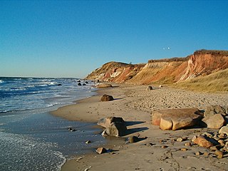
Makonikey Beach cliffs in Fall 2007.
In the late 19th and early 20th centuries, Makonikey was known for its grand hotel, long since torn down.
Today the area is semi-rural, with houses generally located on lots of greater than 3 acres (12,000m2). The general feeling is that of "Up Island" even though the location is right on the edge of "Down Island". The winding dirt roads through the woods can be quite confusing, and are not properly marked either on maps or GPS - many of the roads listed are in fact "paper" roads, and still forested. As a result, most residents have affixed signs to direct visitors and delivery people to their houses (car GPS and online mapping services have not historically accurately mapped the area, but Google Maps has recently been updated with an accurate map of the area). These signs are usually in the form of some local animal or object, and are still the easiest way of finding most of the houses.
This postcard, date unknown, reads, "This shows the big house, part of the wharf and the bathing beach at Makonikey. We are just opposite to Woods Hole, 3 miles from Vineyard Haven and about 5 from Oak Bluffs. We are planning to sail to Gay Head to-day. Are having a good time. H. H. Carey to Mr. Charles R. Bemis, Northboro, Mass."
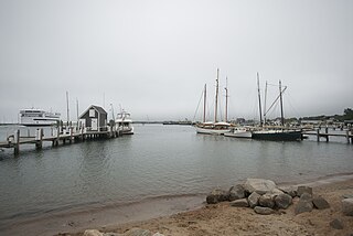
Like the majority of Martha's Vineyard housing stock, most of the houses in Makonikey are used as summer residences. Lower Makonikey has more year-round residents, and is considered one of the more desirable neighborhoods in Vineyard Haven, as the houses and lots tend to be larger than usual for that town, combined with waterviews and beach access (this is generally true of the neighborhoods in Vineyard Haven between Lamberts Cove Road and the Vineyard Sound, Northern Pines, Pilot Hill, and Lower Makonikey)
Lower Makonikey and Upper Makonikey are the subject of 2 separate associations, the Lower Makonikey Corporation and the Upper Makonikey Trust. The associations' main duties are road and beach maintenance. Beach access is private, like many other beaches in Massachusetts.
Notes
↑ Banks, Charles E., The History of Martha's Vineyard, Mass., Volume II. (Dukes County Historical Society)
A geographic coordinate system is a coordinate system that enables every location on Earth to be specified by a set of numbers, letters or symbols. The coordinates are often chosen such that one of the numbers represents a vertical position and two or three of the numbers represent a horizontal position; alternatively, a geographic position may be expressed in a combined three-dimensional Cartesian vector. A common choice of coordinates is latitude, longitude and elevation. To specify a location on a plane requires a map projection.
This page is based on this Wikipedia article Text is available under the CC BY-SA 4.0 license; additional terms may apply. Images, videos and audio are available under their respective licenses.
Related Research Articles
Aquinnah is a town located on the island of Martha's Vineyard in Massachusetts. Until 1997, the town was called Gay Head. The population was 311 at the 2010 U.S. census. It is known for its beautiful clay cliffs and quiet natural serenity. In 1965, Gay Head Cliffs were designated as a National Natural Landmark by the National Park Service.
Chilmark is a town located on Martha's Vineyard in Dukes County, Massachusetts, United States. The population was 866 at the 2010 census. The fishing village of Menemsha is located on the western side of the town along its border with the town of Aquinnah. Chilmark had the highest median home sale price of any town or city in Massachusetts in 2013.
Edgartown is a tourist destination on the island of Martha's Vineyard in Dukes County, Massachusetts, United States, for which it is the county seat.
Oak Bluffs is a town located on the island of Martha's Vineyard in Dukes County, Massachusetts, United States. The population was 4,527 at the 2010 United States Census. It is one of the island's principal points of arrival for summer tourists, and is noted for its "gingerbread cottages" and other well-preserved mid- to late-nineteenth-century buildings.
Vineyard Haven is a community within the town of Tisbury, Massachusetts on Martha's Vineyard. It is listed as a census-designated place (CDP) by the U.S. Census Bureau with a population of 2,114 as of the 2010 census.
West Tisbury is a town located on Martha's Vineyard in Dukes County, Massachusetts, United States. The population was 2,740 at the 2010 census. Along with Chilmark and Aquinnah, West Tisbury forms "Up-Island" Martha's Vineyard.
Nantucket Sound is a roughly triangular area of the Atlantic Ocean offshore from the U.S. state of Massachusetts. It is 30 miles (48 km) long and 25 miles (40 km) wide, and is enclosed by Cape Cod on the north, Nantucket on the south, and Martha's Vineyard on the west. Between Cape Cod and Martha's Vineyard it is connected to the Vineyard Sound. Ports on Nantucket Sound include Nantucket and Hyannis, Massachusetts.
The Islands is the collective name for the set of large islands south of Cape Cod in the southeast corner of the U.S. state of Massachusetts: Nantucket, Martha's Vineyard, the Elizabeth Islands, and a small number of minor islands. The Islands are the location of numerous beach resorts, celebrity second homes, and preserved buildings dating back to the whaling era.
West Chop is a residential area located in the town of Tisbury, Massachusetts on the north end of the island of Martha's Vineyard. It is a peninsula surrounded on the north and west by Vineyard Sound and on the east by Vineyard Haven Harbor. A lighthouse, West Chop Light, stands at the north end of the chop. It is accessible by car from Vineyard Haven by two roads, Franklin Street and Main Street.
West Chop Light is a lighthouse station located at the entrance of Vineyard Haven Harbor in Tisbury, Massachusetts on the northern tip of West Chop, a few miles from the village of Vineyard Haven.
Lambert's Cove Beach is a well known beach in the town of West Tisbury on the island of Martha's Vineyard in Massachusetts, United States. The beach is located off Lambert's Cove Road, and is situated in a cove off of Vineyard Sound facing west towards the Elizabeth Islands. It is known chiefly for the beauty of the beach and the setting, which recalls a Caribbean cove.
Parking at the beach is limited, and during the busy summer season only residents and guests residing in the town of West Tisbury are allowed to use the beach. This has created an understandable amount of dissension on the island.
Menauhant is a neighborhood at the southern end of Central Avenue in East Falmouth, Massachusetts, United States. The community, which lies between Bournes Pond on the west and Eel Pond on the east, is located across Vineyard Sound from Martha's Vineyard. The community has approximately 105 homes, the earliest of which date to the 1870s, a small chapel that serves the community during the summer months, and the public Menauhant Beach. The neighborhood is the home of the Menauhant Yacht Club, which owns two private beaches, tennis courts and several boats, and hosts a summer program for members.
Lambert's Cove is a region in Tisbury and West Tisbury, Massachusetts, on the island of Martha's Vineyard. It extends from Upper Lambert's Cove in west Tisbury to Lower Lambert's Cove in Tisbury. Lambert's Cove Road accesses several roads of note, including Makonikey and Longview. It is noted for its picturesque views of the hilly region of "up island." The road is the only access to West Tisbury's north shore coastline, and accesses the only public beach of the town. Some sites of note found along Lambert's Cove include Lambert's Cove Beach, Makonikey beach, Cottle's lumberyard, the old cranberry bog, Duarte's Pond and Seth's Pond. It also accesses the FOCUS Study Center, a faith-based summer camp near Seth's Pond. Lambert's Cove is also mentioned in popular folk artist James Taylor's song "Terra Nova", sung by then wife Carly Simon.
The William Street Historic District is a historic district in Vineyard Haven, Massachusetts, on the island of Martha's Vineyard. The district includes houses on William Street from Woodlawn Avenue in the north to several houses south of Camp Street. It represents the single best preserved area of mid 19th century houses in Vineyard Haven.
The West Chop Club Historic District is a historic district in Tisbury, Massachusetts, on the island of Martha's Vineyard. The district represents a well-preserved planned summer resort community of the late 19th century. Located in and around Iroquois Avenue, the district encompasses the northernmost portion of West Chop, a peninsula that separates Vineyard Sound and the sheltered waters of Vineyard Haven Harbor, an area that was developed by the West Chop Land Company in the 1880s. The land is now owned by the West Chop Land Trust and managed by the private West Chop Club.
The district was listed on the National Register of Historic Places in 2007.
The Old Mill is an historic mill building at 690 Edgartown-West Tisbury Road in West Tisbury, Massachusetts, on the island of Martha's Vineyard. The current structure was built c. 1848, and occupies a site that has seen industrial use since the 17th century. The property is currently owned by the Martha's Vineyard Garden Club.
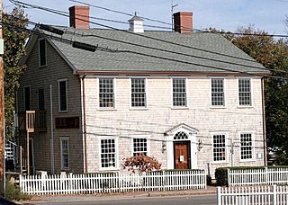
The Ritter House is an historic house on Beach Street in Vineyard Haven, Massachusetts, USA, and is listed on the National Register of Historic Places. The house is one of the few remaining Federal period buildings in Vineyard Haven. It has had a succession of occupants and uses, and as of 2007 served as a retail establishment.
Martha's Vineyard Transit Authority(VTA) is a bus transportation system serving Martha's Vineyard, Massachusetts.