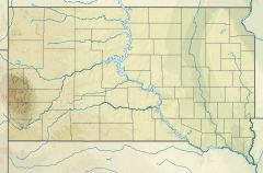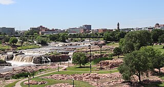
The Big Sioux River is a tributary of the Missouri River in eastern South Dakota and northwestern Iowa in the United States. It flows generally southwardly for 419 mi (674 km), and its watershed is 9,006 sq mi (23,330 km2). The United States Board on Geographic Names settled on "Big Sioux River" as the stream's name in 1931. The river was named after the Lakota people which was known by them as Tehankasandata, or Thick Wooded River.
Castle Creek is a tributary of Rapid Creek, approximately 14 mi (23 km) long, in western South Dakota in the United States.
The Paw Paw River is located in the U.S. state of Michigan in the southwest portion of the lower peninsula. It is formed by the confluence of the north and south branches at 42°15′17″N85°55′36″W in Waverly Township in the northeast of Van Buren County. It flows approximately 61.8 miles (99.5 km) through Van Buren County and Berrien County until joining the St. Joseph River just above its mouth on Lake Michigan at Benton Harbor.
French Creek is an intermittent stream located in the Black Hills region of western South Dakota, United States. It is a tributary of the Cheyenne River. French Creek flows year-round, but in drier periods it flows into an underground drainage near the eastern boundary of Custer State Park and never reaches the Cheyenne.

The Lac qui Parle River is a tributary of the Minnesota River, 118 miles (190 km) long, in southwestern Minnesota in the United States. A number of tributaries of the river, including its largest, the West Branch Lac qui Parle River, also flow in eastern South Dakota. Via the Minnesota River, the Lac qui Parle River is part of the watershed of the Mississippi River, draining an area of 1,156 square miles (2,990 km2) in an agricultural region. Slightly more than two-thirds of the Lac qui Parle watershed is in Minnesota. Lac qui parle means "lake which speaks" in the French language, and was a translation of the Sioux name for Lac qui Parle, a lake on the Minnesota River upstream of the mouth of the Lac qui Parle River.

The Licking River is a tributary of the Muskingum River, about 40 mi (65 km) long, in central Ohio in the United States. Via the Muskingum and Ohio Rivers, it is part of the watershed of the Mississippi River.

Split Rock Creek State Park is a state park of Minnesota, USA, located in Ihlen, or just south of Pipestone.
Carp River is a 40.2-mile-long (64.7 km) river in Chippewa and Mackinac counties in the U.S. state of Michigan. 21.7 miles (34.9 km) of the river were added to the National Wild and Scenic Rivers System in 1992.
Cedar River is an 11.6-mile-long (18.7 km) stream in Antrim County in the U.S. state of Michigan and is part of the Elk River Chain of Lakes Watershed, a tributary of Lake Michigan.
Coldwater River is a 29.5-mile-long (47.5 km) stream in the U.S. state of Michigan. Located in Branch County, the river rises in Ovid Township at 41°50′14″N84°59′13″W as the outflow of Coldwater Lake. Flowing north and west, it is joined by the outflow from the Lake of the Woods and continues north for several miles. West of the city of Coldwater, it flows through a series of lakes: South Lake, Messenger Lake, Cemetery Lake, North Lake, Randall Lake, Morrison Lake, Craig Lake, and Hodunk Pond. It then continues to the northwest and empties into the St. Joseph River in the village of Union City at 42°03′58″N85°07′48″W.
Sioux National Forest was a National Forest (NF) established by Executive Order 908 on July 1, 1908. The order called for the consolidation of the following national forests and forest units into a single entity:

Pipestone Creek is a 53.2-mile-long (85.6 km) river in southwestern Minnesota and southeastern South Dakota.
Buchanan, originally named Mouth of Bear, is an unincorporated community located in Lawrence County, Kentucky, United States at the mouth of Bear Creek where it joins the Big Sandy River, five miles downstream from the mouth of Blaine Creek.

Dewey is an unincorporated community near the southwest corner of Custer County, South Dakota, United States, less than one mile from the Wyoming border in a prairie region of the Black Hills. There are approximately five or six homes in town. Dewey has a volunteer fire department in the Edgemont city district.
Elm Creek is a stream in Fall River and Custer counties, South Dakota, in the United States. It is a tributary of the Cheyenne River.
American Creek is a stream in northwestern Bruele County, South Dakota, United States, that is a tributary of the Lake Francis Case reservoir on the Missouri River. The creek's headwaters are just east of the town of Pukwana and its mouth is in the city of Chamberlain. In addition to the two communities, the creek flows through the Pukwana and Chamberlain townships.
Clarks Fork Creek, also called Clarks Fork or Sand Creek, is a stream in Harding County, South Dakota, United States. It is a tributary of Grand River.
Flynn Creek is a stream in Custer County, South Dakota. Its source is the Flynn Creek spring near the unincorporated community of Sanator, and its mouth is at the south fork of the Lame Johnny Creek, which later flows into the Cheyenne River about 20 miles (32 km) away.
Walnut Creek is a 30-mile-long (48 km) tributary of the South River in the U.S. state of Georgia. It originates in the city of Hampton in Henry County and flows into South River, which is a branch of the Ocmulgee River.
Lakota Lake is a small lake in the Norbeck Wildlife Preserve of Custer County, South Dakota.