
Andrews is a ghost town in Harney County, Oregon, United States. It is located south of Steens Mountain and near the Alvord Desert.

Kernville is an unincorporated community in Lincoln County, Oregon, United States. It is located near the intersection of U.S. Route 101 and Oregon Route 229, where the Siletz River enters Siletz Bay. There are two communities, known as "old" and "new" Kernville, in close proximity. Old Kernville is considered a ghost town.

Bridal Veil is a virtual ghost town located in Multnomah County, Oregon, United States. It was established in the 1880s during a logging boom by a logging company as it harvested timber on nearby Larch Mountain to be a company mill town around a sawmill. It had a close relationship with the logging town of Palmer for the first 50 years of its history. As of November 2011, all that remains of the town is a post office and a cemetery. The site is located near the west end of the Columbia River Gorge.

Ashwood is a ghost town in Jefferson County, Oregon, United States, 32 miles (51 km) northeast of Madras.
Termo is a ghost town in Lassen County, California. It was located on the now abandoned Southern Pacific Railroad line 32 miles (51 km) north-northeast of Susanville, at an elevation of 5305 feet. This town straddles U.S. Highway 395 north of Ravendale.
Friend is an unincorporated community in Wasco County in the U.S. state of Oregon. Considered a ghost town, little remains of the community except the Friend Store, a one-room schoolhouse, and a cemetery.

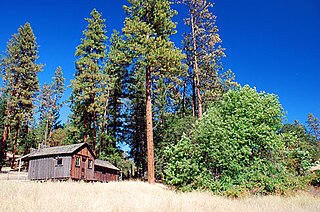
Cornucopia is a ghost town built during the gold mining boom of the 1880s in Eastern Oregon, United States. The town was officially platted in 1886 and was a mining town with various levels of success until it was abandoned in 1942. It is now primarily a tourist attraction as a ghost town. It is located east of Baker City high in the mountains of Pine Valley almost due north of Halfway, Oregon, on Oregon Route 86.

Kelton is a ghost town, just north of the Great Salt Lake, in the Park Valley area of Box Elder County, Utah, United States. The town was inhabited during the period of 1869–1942. Once an important section station on the First transcontinental railroad, Kelton was dependent on the railroad throughout its history. The town suffered serious setbacks in the 1880s when its busy stagecoach route to Boise, Idaho was discontinued, and in the 1900s when the Lucin Cutoff left it off the main rail line. The strongest earthquake in Utah history caused severe damage in 1934, but Kelton ceased to exist only when the rails were completely removed during World War II.
Buncom is an abandoned mining town at the confluence of the Little Applegate River and Sterling Creek in Jackson County, Oregon, United States. It is approximately 20 miles (32 km) southwest of Medford, at an elevation of 1,783 feet (543.5 m) above sea level. The site is promoted by the local historical society as a ghost town.

Golden is an abandoned mining town located at Coyote Creek in Josephine County, Oregon, United States.
Lime is an unincorporated community and ghost town in the northwest United States, located in Baker County, Oregon. Five miles (8 km) north of Huntington on Interstate 84, it is near the confluence of Marble Creek and the Burnt River on the Union Pacific Railroad. The historic Oregon Trail passes through Lime.
Saint Joseph is an unincorporated community in Yamhill County, Oregon, United States. It is located about two miles (3.2 km) west of Lafayette near Oregon Route 99W. The area is sometimes known as "St. Joe".
Clifton is an unincorporated community in Clatsop County, Oregon, United States. It is located north of U.S. Route 30, about nine miles northwest of Westport on the south bank of the Columbia River. It is on Clifton Channel across from Tenasillahe Island.
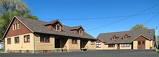
The Lamonta Compound – Prineville Supervisor's Warehouse is a complex of buildings and related infrastructure owned an operated by the Ochoco National Forest in Prineville, Oregon, United States. Built by the Civilian Conservation Corps in 1933–1934, it is the headquarters for field operations in the national forest and is typical of projects carried out by the CCC on behalf of the Forest Service. It represents that era's shift in the Forest Service's architectural vision toward comprehensive site planning, as well as its policy evolution from custodial superintendence of the national forests toward active natural resource management.
Maitland, originally called Garden City and sometimes misspelled Midland, is a ghost town in Lawrence County, South Dakota, United States. It was a mining community that boomed during the Black Hills Gold Rush, but was abandoned by about 1915.
Cabell City is a ghost town and former mining town in Grant County, Oregon.

Stauffer was an unincorporated community located in Lake County, Oregon, United States. The first homesteaders arrived in the area around 1910. By 1918, the local population was declining rapidly due to the harsh environment. Today, Stauffer is a ghost town with no population and no surviving structures. The site is located approximately 12 miles (19 km) south of U.S. Route 20 between Bend and Burns, Oregon. The nearest inhabited place is Hampton, Oregon, 21 miles (34 km) northwest of the Stauffer site.

Fleetwood was an unincorporated community located in Lake County, Oregon, United States. The first homesteaders arrived in the area around Fleetwood in 1905. The Fleetwood post office was opened in 1913. By 1920, the local population was declining due to a severe drought that dried up surface water and lowered the water table in the area around Fleetwood. Today, Fleetwood is a ghost town with no population and no surviving structures at the townsite. The site is located approximately 10 miles (16 km) east of Fort Rock state park. The nearest inhabited place is the small unincorporated community of Fort Rock, Oregon, which is 9 miles (14 km) west of the Fleetwood townsite.


