Lands of Brownmuir

Last updated

Lands of Brownmuir
Beith, North Ayrshire, Scotland
Brown Muir Hill near Nebanoy.JPG
Brownmuir Hill plantation and the Rakerfield drove road.
Scotland relief location map.jpg
Red pog.svg
Lands of Brownmuir
Coordinates 55°46′11″N4°35′53″W / 55.769818°N 4.597952°W / 55.769818; -4.597952 Coordinates: 55°46′11″N4°35′53″W / 55.769818°N 4.597952°W / 55.769818; -4.597952
Grid reference grid reference NS237656
TypeLaird's dwelling
Site information
OwnerPrivate
Controlled byHamilton
Open to
the public
No
ConditionNow a farm
Site history
Built18th century
Built byHamilton family
MaterialsStone

The lands of Brownmuir, Brown Muir (1832) [1] or Brimmer (1821) [2] in Scots were located in the Parish of Beith, at the western boundary between East Renfrewshire and North Ayrshire, Scotland. [3] The settlements of Brownmuir and Rakerfield [4] were part of the old Brownmuir Estate. Brownmuir or Brimmer Hill at feet is a prominent eminence in the parish and it overlooks the area with Lochlands Hill and Cuff Hill relatively nearby. The old estate of Threepwood lay to the east.

Contents

The History of the Lands of Brownmuir

The lands of Brownmuir lay in the Regality of Kilwinning and Bailiary of Cunninghame. The boundary to the west was with the Lands of Threepwood. A substantial laird's style dwelling is not indicated on the available 18th century maps of the area.

Brownmuir

The radio shack and aerial on Brimmer Hill. Brown Muir Hill Radiomast.JPG
The radio shack and aerial on Brimmer Hill.

The name 'Brownmuir' or 'Brimmer' [5] may derive from the appropriately descriptive terms 'brown' and 'moor'. The present day Brownmuir Farm is located on a lane that runs between Threepwood Road and the Boydstone and Knowes Roads.

A drove road once ran from near Brownmuir Farm passed Rakerfield Farm to join the existing road near Newmills. In 1856 a lint mill was located on the Muir Burn near Brownmuir Farm with a wooden footbridge and two dams on the watercourse. The mill was linked to the Boydston Road by a short lane. This mill was upstream of Mill of Beith and the 'Warlock Craigie Spout' or waterfall. [6]

The ruins of the long abandoned Langbank Farm are situated on the northern side of Brownmuir Hill near the old drover's road's junction with the Newmills to Threepwood road.

Brownmuir Hill

Brownmuir or Brimmer Hill Plantation is mainly composed of oak, rowan, Scots Pine, birch and beech. The area is very wet with a high humidity and as a consequence the habitat is characterised by a large number of Sphagnum moss hummocks which rise up as much a metre above ground level. [4] A whinstone quarry and a gravel pit were located on the Brownmuir Hill as were several well made cart tracks. [6] On the summit are the remains of a radio shack and aerial in a remote fenced off area once supplied with mains electricity.

The road that ran around the southern slopes of the hill (see photograph) appears from its width to have been a 'drove road' used to drive cattle and sheep to market and considerable effort was clearlyctaken to construct good drystone dykes to confine stock to the road itself. It may also have been used by pack animals/mule trains and was built probably before wheeled vehicles were introduced on farms in the late 18th century; large sledges were in use by farmers at this time to move heavy loads.

Rakerfield

The ruins of Rakerfield. Rakerfield ruins - eastern view.JPG
The ruins of Rakerfield.

In 1615 William Montgomerie, a merchant, lived at Rakerfield that was situated just off the above-mentioned old drove road that once formed a direct route from Beith to Howwood. [7] Rakerfield Farm was a two storey dwelling of unusual construction, with well carved stone window and door surrounds, etc. It was once used as hunting lodge and a dwelling for a gamekeeper. Mrs & Mrs Blair, lived here at the time of the construction of Kirkleegreen Reservoir and it was purchased upon their death by Ayrshire County Council who the roof removed.

A 'Raker' is the Scot's for a traveller [8] which may link with the old drove road that once ran past the property.

The Lairds

Hamiltons

The Hamilton family of Brownmuir were probably descended from Udston, ancestor of the Hamilton's of Wishaw, however Dobie records that they were originally a cadet branch of the Hamiltons of Duchal and held Brownmuir for some centuries. [9] The first recorded laird from circa 1611 is Hugh Hamilton [10] and the next Hamilton heir is William, noted in the 1615 testament of William Montgomerie, merchant in Rakerfield. [7] William appears in the inventory of Hew Montgomerie of Boghall, as having a claim for dry multures and he was in 1685 recorded on the roll of the Lochwinnoch heritors, as the feuar of the land of Auchinbothie-Blair. William Hamilton, the elder of Brownmuir, is recorded as a creditor in 1648 of Robert Gawane (Gavin) of Beith. [7] In 1646 William's heir was also a William and his daughter was Ursula who married John Fulton of Boydston. [7] In the 1630s the nearby Townend of Threepwood Farm was obtained by a Thomas Fulton. [11]

In 1648 and 1701 William Hamiltoun of Brownmuir was an elder of Beith Kirk and a feuar circa 1658 of a farm of the lands of Auchinbothie Blair. [7] William had two offspring, namely Jean and Ursula. Jean (b. 1662) married the antiquary and writer Robert Hamilton of Wishaw and her descendants succeeded to the title of Lord Belhaven. [12] James Cochrane of Auchincreuch and Mainshill married Ursula circa 1691. [12]

Crawfurds

In 1796 William, seventh Lord Belhaven sold the lands and mills of Brownmuir to Hugh Crawfurd who was a baillie and a writer in Greenock. [12] Hugh Crawfurd married twice and had by his first wife had Hugh Crawfurd of Hillend and the second James, by Ann Dunlop, inherited the lands and sold them in 1829. [13]

Pratts and later owners

John Pratt of Glentarkie in Fife purchased the lands from Lord Belhaven and became sole owner. John had married Isabella Crawfurd, third daughter of Hugh Crawfurd and upon their death the property passed jointly to Maria Eliza Stevenson and Margaret Stevenson. [9] A Stevenson family once also lived at Townend of Threepwood.

Scotland relief location map.jpg
Red pog.svg
Brownmuir
Lands of Brownmuir

Water Mills

A number of water mills were associated with the Lands of Brownmuir, including the Mill of Beith and probably the lint mill used for processing flax that was located on the Muir Burn near Brownmuir Farm above Knowes Mill, with an associated retting pond. The name of this lint mill is unrecorded. A mill also existed at Boydston on the opposite side from Mill of Beith and Davies o'the Mill may have been another flax mill. Bleach works were located at Threepwood and Sunnyside of Threepwood for bleaching linen made from the processed and woven flax.

The evidential records for these are that in 1677, an agreement is recorded between William Hamilton of Brownmuir, who was a heritable proprietor of the corn mill at Mill of Beith, and the suckeners of that mill. [7]

The text of the agreement is as follows, laying out the amount of meal that the miller could take as payment for his work - "And the said coags to be the just proportionable pairt of the peck whereof the shilling is first measured at the said milne, and that in lieu and place and for satisfaction of all knaveschip, bunnock. gratification, or any other consuetude formerlie dew or is accustomed to be paid or required at the said mylne, and the saids two cogfulls of meill are to be kepped at the mylne eye and hand waved by the owner of the meill; and in case the millar of the said mylne dissent through dissatisficatione with the waving thereof, in that case the said milner is to have libertie to sift the samen, and instead thereof shall have two coagfulls of sifted clean meall straiked ; and whilke two cogfulls of meal extending both to the thrid part of ane peck." [12]

It is also recorded that when in 1796 William Hamilton, seventh Lord Belhaven, sold the Lands of Brownmuir to Hugh Crawfurd of Greenock, mills 'plural' are mentioned as being included in the sale. [12]

See also

Related Research Articles

Bourtreehill House

Bourtreehill House and the enclosed land on which it was built form the original estate of Bourtreehill. The wooded hill-top, a distinctive feature of the estate, is now a landmark that sits at the centre of modern North Bourtreehill in the district of North Ayrshire on the west coast of Scotland.

Cunninghamhead is a hamlet in North Ayrshire, Scotland. It was the centre of the lands of Cunninghamhead, Perceton and Annick Lodge in Cunninghame. This mainly rural area is noted for its milk and cheese production and the Ayrshire, Cunninghame or Dunlop breed of cattle.

Dunlop is a village and parish in East Ayrshire, Scotland. It lies on the A735, north-east of Stewarton, seven miles from Kilmarnock. The road runs on to Lugton and the B706 enters the village from Beith and Burnhouse.

Hessilhead

Hessilhead is in Beith, North Ayrshire, Scotland. Hessilhead used to be called Hazlehead or Hasslehead. The lands were part of the Lordship of Giffen, and the Barony of Hessilhead, within the Baillerie of Cunninghame and the Parish of Beith. The castle was situated at grid reference NS380532.

Kilwinning Abbey Monastery in North Ayrshire, Scotland, UK

Kilwinning Abbey is a ruined abbey located in the centre of the town of Kilwinning, North Ayrshire.

Barony and Castle of Giffen Barony in the former District of Cunninghame, now North Ayrshire

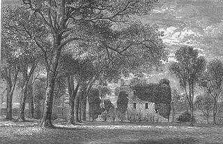
The Barony of Giffen and its associated 15th-century castle were in the parish of Beith in the former District of Cunninghame, now North Ayrshire. The site may be spelled Giffen or Giffin and lay within the Lordship of Giffin, which included the Baronies of Giffen, Trearne, Hessilhead, Broadstone, Roughwood and Ramshead; valued at £3,788 9s 10d. The Barony of Giffen comprised a number of properties, including Greenhills, Thirdpart, Drumbuie, Nettlehirst and Balgray, covering about half of the parish of Beith. Giffen was a hundred merk land, separated from the Barony of Beith, a forty-pound land, by the Powgree Burn which rises on Cuff hill. The Lugton Water or the Bungle Burn running through Burnhouse may have been the Giffen barony boundary with that of the adjacent barony and lands of Aiket castle.

Broadstone Castle Castle in Ayrshire, Scotland

Broadstone lies close to the small village of Gateside in North Ayrshire, Scotland about half a mile east of Beith in the old Barony of Giffen.

Lands of Lainshaw The Lands Of Lainshaw Have Been In Place For Many Years And Was Used In The War.

The Lands of Lainshaw lie in Strathannick and were part of the Lordship of Stewarton, in East Ayrshire, Scotland. Lainshaw House is a category B listed mansion, lying in a prominent position above the Annick Water and its holm in the Parish of Stewarton, Scotland. Part of the much older Lainshaw Castle is contained within the several later building phases of the present day Lainshaw House. The names 'Langshaw' or 'Langschaw' were used in historic times. Law Mount near the High and Laigh Castleton farms has been suggested as the site of the original castle, granted in the 12th century to Godfrey de Ross by Hugo de Morville.

Hill of Beith Castle

The old Barony and castle, fortalice, or tower house of Hill of Beith lay in the feudal Regality of Kilwinning, within the Baillerie of Cunninghame, and the Sherrifdom of Ayr, now the Parish of Beith, North Ayrshire, Scotland.

Lowes Loch (Ayrshire) Lake in the United Kingdom

Lowes Loch, The Lochs or Loch of Hill is now a small natural freshwater loch in the North Ayrshire Council Areas, lying in a glacial kettle hole, once of greater extent, lying below Brownmuir and Lochland Hills on the Threepwood Road, near Beith, in the Parish of Beith. The loch may once have had a small island within it.

The Lands of Cocklebie or Cocklebee formed an estate possessing a common border with the estates of Lainshaw, the Corsehill, and the town of Stewarton, East Ayrshire, Parish of Stewarton, Scotland.

Lands of Bogston

Bogston or later Bogstone was a small estate in the old Barony of Giffen near Barrmill in the Parish of Beith, North Ayrshire, once held by collateral descendants of the Montgomeries of Broadstone. The estate covered 160 acres or around 65 hectares, its rental in 1896 being £180 per annum.

The Lands of Roughwood

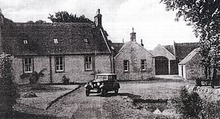
Roughwood once Ruchwood is a farm, originally a estate, possessing at one time a small tower castle. Roughwood is situated near to the town of Beith in North Ayrshire, Scotland; the lands lay within the old Lordship of Giffen.

Barony of Kersland

The remains of the old castle of Kersland lie about 1.5 miles to the north-east of the town of Dalry in North Ayrshire, Scotland, in the old Barony of Kersland. The River Garnock lies nearby.

The Lands of Doura, Dawra, Dawray, DowreyDowray, Dourey or Douray formed a small estate, at one time part of the Barony of Corsehill and Doura, situated near the Eglinton Estate in the Parish of Kilwinning, North Ayrshire, Scotland.

Lands of Willowyard

The ancient lands of Willowyard, Willieyeards, Williyard or Willizeards were part of the holdings of the Regality of Kilwinning, Barony of Beith, and Bailiary of Cuninghame. They later became the property of the Montgomerie family before being sold to the Simson family in 1723. The manor house still survives as part of a business premises and the nearby industrial estate and whisky bond carry the name 'Willowyards'.

Lands of Marshalland

The lands of Marshalland, Marsheland, Marsheyland or Marshyland were part of the holdings of the Barony of Beith, Regality of Kilwinning and Bailiary of Cuninghame. They became the property of the Lyle family, then the Shedden family, passing next to the Spier's family before finally becoming part of the Spier's Trust lands. The laird's house and farm were demolished in the 1960s.

Lands of Threepwood

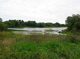
The lands of Threepwood were located in the Parish of Beith, at the eastern boundary between East Renfrewshire and North Ayrshire, Scotland. The settlements of Midtown, Townhead and Townend were part of the old Threepwood Estate. Cuffhill at 675 feet is the highest eminence in the parish and it overlooks the area with Little Hill and Cuff Hill and Little Hill plantations nearby, now situated next to the entirely artificial Cuffhill Reservoir.

The lands of Broomlands or Broumlands formed a small country estate about a mile to the east of Irvine, North Ayrshire, Scotland situated on the east bank of the Annick Water in the Parishes of Dreghorn and Irvine.

Lands of Tour and Kirkland Human settlement in Scotland

The Lands of Tour and Kirkland (NS416406) formed a small estate close to the old Kirktoun and St Maurs-Glencairn collegiate church about 1 km south-east of Kilmaurs, East Ayrshire, Parish of Kilmaurs, Scotland. The word 'Tour' in Scots refers to a 'tower' and 'kirk' to a parish church.

References

Notes;

  1. John Thomson Retrieved : 2013-12-30
  2. John Ainslie's Map Retrieved : 2013-12-30
  3. Brownmuir Farm Retrieved : 2013-12-30
  4. 1 2 Geolocation Retrieved : 2013-12-30
  5. Paterson, Page 115
  6. 1 2 6 in OS Map Retrieved : 2013-12-30
  7. 1 2 3 4 5 6 Paterson, Page 84
  8. Scots Dictionary Retrieved : 2013-12-31
  9. 1 2 Dobie, page 74
  10. Paterson, Page 83
  11. Paterson, Page 118
  12. 1 2 3 4 5 Paterson, Page 85
  13. Paterson, page 86

Sources and Bibliography;

  1. Dobie, James D. (ed Dobie, J.S.) (1876). Cunninghame, Topographized by Timothy Pont 1604–1608, with continuations and illustrative notices. Glasgow : John Tweed.
  2. Paterson, James (1863–66). History of the Counties of Ayr and Wigton. IV. - I - Cunninghame. Edinburgh: J. Stillie.