
Landslides, also known as landslips, are several forms of mass wasting that may include a wide range of ground movements, such as rockfalls, shallow or deep-seated slope failures, mudflows, and debris flows. Landslides occur in a variety of environments, characterized by either steep or gentle slope gradients, from mountain ranges to coastal cliffs or even underwater, in which case they are called submarine landslides.

A megatsunami is a very large wave created by a large, sudden displacement of material into a body of water.
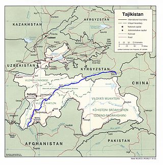
The Vakhsh, also known as the Surkhob, in north-central Tajikistan, and the Kyzyl-Suu, in Kyrgyzstan, is a Central Asian river, and one of the main rivers of Tajikistan. It is a tributary of the Amu Darya river.

Annapurna IV is a mountain of the Annapurna mountain range in the Himalayas which is located in Nepal. Along with the taller Annapurna II, it is isolated from the other peaks in the range via a major col. It is the 4th highest peak of the range. It was first climbed in 1955 by a German expedition led by Heinz Steinmetz via the North Face and Northwest Ridge. The summit party comprised Steinmetz, Harald Biller, and Jürgen Wellenkamp.

Sindhupalchowk District is a part of Bagmati Province and one of the seventy-seven districts of Nepal, with an area of 2,542 km2 (981 sq mi). The district's headquarters is in Chautara. In 2006, 336,478 people resided in 79 village development committees, in 2011 there were 287,798.

The Kosi or Koshi is a transboundary river which flows through China, Nepal and India. It drains the northern slopes of the Himalayas in Tibet and the southern slopes in Nepal. From a major confluence of tributaries north of the Chatra Gorge onwards, the Kosi River is also known as Saptakoshi for its seven upper tributaries. These include the Tamur River originating from the Kanchenjunga area in the east and Arun River and Sun Kosi from Tibet. The Sun Koshi's tributaries from east to west are Dudh Koshi, Bhote Koshi, Tamakoshi River, Likhu Khola and Indravati. The Saptakoshi crosses into northern Bihar, India where it branches into distributaries before joining the Ganges near Kursela in Katihar district.
Kimathanka is a Village in Bhotkhola rural municipality of Sankhuwasabha District of Province No. 1, Nepal and serves as the Nepalese counterpart of the Nepal-China border at Zhentang (Chentang). At the time of the 1991 census, it had a population of 303 people living in 50 individual households.

The Sunkoshi, also spelt Sunkosi, is a river of Nepal that is part of the Koshi or Saptkoshi River system in Nepal. Sunkoshi has two source streams, one that arises within Nepal in Choukati, and the other more significant stream that flows in from Nyalam County in the Tibet region of China. The latter is called Bhote Koshi in Nepal and Matsang Tsangpo in Tibet. Due to the significant flows from Bhote Koshi, the Sun Koshi river basin is often regarded as a trans-border river basin.
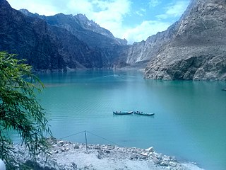
Attabad Lake is a lake located in the Gojal region of Hunza Valley in Gilgit−Baltistan, Pakistan. It was created in January 2010 as the result of a major landslide in Attabad. The lake has become one of the biggest tourist attractions in Gilgit−Baltistan, offering activities like boating, jet-skiing, fishing and other recreational activities.

The Seti Gandaki River, also known as the Seti River or the Milk River, is a river of western Nepal, a left tributary of the Trishuli River. Its gorges around Pokhara are a major attraction for tourists worldwide.

On 2 August 2014, due to heavy rainfall, a landslide occurred at the Sunkoshi river, killing 156 people and blocking the river to form an artificial lake in Sindhupalchok District, Nepal. Araniko Highway, the main artery of goods and people flow to China, was blocked by the landslide ripping out 5 km of highway, and causing huge traffic jam.
Sunkoshi Small Hydropower Plant is located in Dhuskun of Sindhupalchok District in central Nepal. It downstream where the Sunkoshi and Bhotekoshi Rivers meet. Construction on the plant began in 2003 and it was complete in 2005.

The 1847 Nagano earthquake occurred at about 21:30 local time on 8 May at Nagano, Japan. It had a magnitude of 7.4 on the surface wave magnitude scale. It caused the destruction of many houses in Nagano and at least 8,600 people were killed. The earthquake triggered many landslides, the largest of which dammed the Sai River. 19 days later, the failure of this earthquake dam caused a flood that destroyed many more houses and killed 35 people.

The 1975 Banqiao Dam failure was the collapse of the Banqiao Dam and 61 other dams in Henan, China, under the influence of Typhoon Nina in August 1975. The dam collapse created the third-deadliest flood in history which affected a total population of 10.15 million and inundated around 30 cities and counties of 12,000 square kilometers, with an estimated death toll ranging from 26,000 to 240,000. The flood also caused the collapse of 5 million to 6.8 million houses. The dam failure took place when many people were preoccupied with the Cultural Revolution.
'Sunkoshi Marin Diversion Project' is one of the National Pride Projects being developed by Ministry of Energy, Water Resources and Irrigation (Nepal). The project got status of National Pride Projects in 20 January 2020.
The 2020 Nepal floods were induced by heavy rains causing landslides and flash floods in western Nepal, and in particular Myagdi District. As of 24 June, Nepal's Ministry of Home Affairs reported 132 dead, 53 missing, and 128 injured in 445 flooding and landslide incidents. Aon reported 401 fatalities from the floods.
Sunkoshi Hydropower Station is a run-of-river hydro-electric plant located in Sindhupalchok District of Nepal. The flow from Sunkoshi River is used to generate 10.05 MW electricity. The plant is owned and developed by Government owned company, the Nepal Electricity Authority. The plant started generating electricity since 1972.
In June 2021, the flood in Melamchi River caused damage in the Melamchi Bazar in Sindhupalchowk District of Nepal killing several locals and some foreigners
At 11:00 p.m. on 20 September 1988, a huge rockslide occurred in the Darbang region of Nepal. The landslide killed 109 people and buried all the houses in the right bank of the river. The volume of landslide was estimated to be about 5 million cubic meters with a dimension of about 750m high ranging from the elevation of 1750 to 1000 m and width of 500m. The debris dammed the Myagdi river for three hours. The debris was gradually eroded by the river without causing flooding in the downstream region.