Notes
- ↑ Steel and Snow quote three lines from a Māori lament and offer translations of local placenames, suggesting these are connected to the impact event, [7] but offer no explanation of how they arrived at these conclusions; notably, they fail to explain how a lament that was composed on the death of a 19th-century North Island chief could possibly relate to the so-called Tapanui crater. Verschuur claims that Otarehua is a placename near Tapanui and that it refers to the Māori name for Antares, and that this may be an indication that the bolide impact happened in the June Taurid meteor stream. [8] However, Goff et al. (2003) provide refutations of these translations; they specifically mention Otarehua. [6] : 800, sect. g
Related Research Articles

A meteoroid is a small rocky or metallic body in outer space. Meteoroids are distinguished as objects significantly smaller than asteroids, ranging in size from grains to objects up to a meter wide. Objects smaller than meteoroids are classified as micrometeoroids or space dust. Many are fragments from comets or asteroids, whereas others are collision impact debris ejected from bodies such as the Moon or Mars.
Otago is a region of New Zealand located in the southern half of the South Island administered by the Otago Regional Council. It has an area of approximately 32,000 square kilometres (12,000 sq mi), making it the country's second largest local government region. Its population was 254,600 in June 2023.
Mahuika crater was a hypothesized impact crater named after the Māori god of fire. It was described as being about 20 ± 2 km wide and over 153 meters (502 ft) deep and on the New Zealand continental shelf at 48.3 South and 166.4 East, to the south of The Snares. A 2017 survey of the purported site found no evidence supporting the existence of the crater.

A bolide is normally taken to mean an exceptionally bright meteor, but the term is subject to more than one definition, according to context. It may refer to any large crater-forming body, or to one that explodes in the atmosphere. It can be a synonym for a fireball, sometimes specific to those with an apparent magnitude of −4 or brighter.

Nothofagus, also known as the southern beeches, is a genus of 43 species of trees and shrubs native to the Southern Hemisphere in southern South America and east and southeast Australia, New Zealand, New Guinea, and New Caledonia. The species are ecological dominants in many temperate forests in these regions. Some species are reportedly naturalised in Germany and Great Britain. The genus has a rich fossil record of leaves, cupules, and pollen, with fossils extending into the late Cretaceous period and occurring in Australia, New Zealand, Antarctica, and South America.

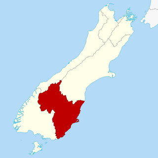
Tapanui is a small town in West Otago in New Zealand's South Island, close to the boundary with Southland region.
West Otago is the local name given to part of the region of Otago, New Zealand, lying close to the border with Southland. It is administratively connected to South Otago, but is geographically separated from it by a range of hills known as the Blue Mountains. The largest settlements in West Otago are Tapanui and Heriot, and other localities within the area include Moa Flat, Edievale, Crookston, Merino Downs, and Waikoikoi. The area described as West Otago is sometimes extended to include Lawrence, Clinton, and Beaumont. The ghost town of Kelso also lies within West Otago. Other notable features of the area include Conical Hill and Landslip Hill, the latter being a major fossil-bearing formation.
The Taurids are an annual meteor shower, associated with the comet Encke. The Taurids are actually two separate showers, with a Southern and a Northern component. The Southern Taurids originated from Comet Encke, while the Northern Taurids originated from the asteroid 2004 TG10, possibly a large fragment of Encke due to its similar orbital parameters. They are named after their radiant point in the constellation Taurus, where they are seen to come from in the sky. Because of their occurrence in late October and early November, they are also called Halloween fireballs. Since 2P/Encke is such a short period comet, the meteors have the slowest impact speed of the annual well-known meteor showers.
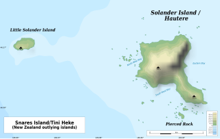
The Solander Islands / Hautere are three eroded remnants volcanic islets towards the western enterance of the Foveaux Strait just beyond New Zealand's South Island. The islands lie 40 km (25 mi) south of the coastline of Fiordland.
Douglas Ralph Emlong was an amateur fossil collector from the Oregon Coast in the northwestern United States. His collections contributed to the discovery and description of numerous extinct marine mammal species, many of which are ancestral to extant groups. Described as an 'indefatigable' fossil collector with 'Promethian prowess in discovery of unprecedented vertebrate fossils', he contributed substantially to the field from the age of fourteen. The ancestral pinniped Enaliarctos emlongi was named in his honor by Annalisa Berta in 1991.
The natural history of New Zealand began when the landmass Zealandia broke away from the supercontinent Gondwana in the Cretaceous period. Before this time, Zealandia shared its past with Australia and Antarctica. Since this separation, the New Zealand landscape has evolved in physical isolation, although much of its current biota has more recent connections with species on other landmasses. The exclusively natural history of the country ended in about 1300 AD, when humans first settled, and the country's environmental history began. The period from 1300 AD to today coincides with the extinction of many of New Zealand's unique species that had evolved there.

The geology of New Zealand is noted for its volcanic activity, earthquakes and geothermal areas because of its position on the boundary of the Australian Plate and Pacific Plates. New Zealand is part of Zealandia, a microcontinent nearly half the size of Australia that broke away from the Gondwanan supercontinent about 83 million years ago. New Zealand's early separation from other landmasses and subsequent evolution have created a unique fossil record and modern ecology.

Southland is New Zealand's southernmost region. It consists of the southwestern portion of the South Island and includes Stewart Island. Southland is bordered by the culturally similar Otago Region to the north and east, and the West Coast Region in the extreme northwest. The region covers over 3.1 million hectares and spans 3,613 km of coastline. As of June 2023, Southland has a population of 103,900, making it the eleventh-most-populous New Zealand region, and the second-most sparsely populated. Approximately half of the region's population lives in Invercargill, Southland's only city.
Bruce Gordon McFadgen is a New Zealand surveyor and archaeologist.

The Eltanin impact is thought to be an asteroid impact in the eastern part of the South Pacific Ocean that occurred around the Pliocene-Pleistocene boundary approximately 2.51 ± 0.07 million years ago. The impact occurred at the north edge of the Bellingshausen Sea 1,500 km (950 mi) southwest of Chile, where the sea floor is approximately 4–5 kilometres (2.5–3.1 mi) deep. The asteroid was estimated to be about 1 to 4 km in diameter. No crater associated with the impact has been discovered. The impact likely evaporated 150 km3 (36 cu mi) of water, generating large tsunami waves hundreds of metres high.
This is a glossary of terms used in meteoritics, the science of meteorites.

The Manuherikia Group is a fluvial-lacustrine sedimentary fill in the Central Otago area of New Zealand, at the site of the prehistoric Lake Manuherikia. The area consists of a valley and ridge topography, with a series of schist-greywacke mountains at roughly ninety degrees to each other. The Manuherika Group occurs in the current basins, and occasionally on the mountains themselves.

Foulden Maar is a fossil site near Middlemarch in Otago, New Zealand. The fossils were deposited in the small deep crater lake of a maar formed around 23 million years ago by a volcano in the Miocene era. The crater lake existed for a period of around 130,000 years, and during this time it gradually filled up with diatomite, composed of annual layers of silica-shelled algae (diatoms). These layers of diatomite have preserved exceptional fossils of fish from the crater lake, and plants, spiders and insects from the sub-tropical forest that developed around the crater. The site is the only known maar of its kind in the Southern Hemisphere and is one of New Zealand's pre-eminent fossil sites. A 2018 proposal to mine Foulden Maar for livestock-food additive attracted significant public opposition. The mining company went into receivership in 2019, and in 2023, the Dunedin City Council reached an agreement with the receivers to purchase the land, including the surrender of the mining permits.
This paleobotany list records new fossil plant taxa that were to be described during the year 2012, as well as notes other significant paleobotany discoveries and events which occurred during 2012.
References
- ↑ Lindqvist, J. K. and D.T. Pocknall, 1983: Stratigraphy and palynology of Late Oligocene to Miocene lignite bearing sediments, eastern Southland. 15th Pacific Science Congress tour guide Bf5.
- ↑ Lindqvist, J. K. 1983: Lignite deposition in deltaic plain environments of Late Oligocene to Early Miocene Gore Formation, east Southland. 15th Pacific Science Congress vol. 1: abstract.
- ↑ D. T. Pocknall (1982). "Palynology of late Oligocene Pomahaka Estuarine Bed sediments, Waikoikoi, Southland, New Zealand". New Zealand Journal of Botany . 20 (3): 263–287. doi: 10.1080/0028825X.1982.10428495 .
- ↑ Cox, Simon; B. Smith Lyttle (2003). "Geological Society of New Zealand Inc, 2003 Annual Conference Field Trip Guides" (PDF). Geological Society of New Zealand. Miscellaneous Publication 116B. Archived from the original (PDF) on 2007-09-22. Retrieved 2007-08-30.
- ↑ J. D. Campbell; A. M. Holden (1984). "Miocene casuarinacean fossils from Southland and Central Otago, New Zealand". New Zealand Journal of Botany . 22 (1): 159–167. doi: 10.1080/0028825X.1984.10425242 .
- 1 2 3 4 5 James Goff; Keri Hulme; Bruce McFadgen (2003). ""Mystic Fires of Tamaatea": attempts to creatively rewrite New Zealand's cultural and tectonic past". Journal of the Royal Society of New Zealand . 33 (4): 795–809. doi: 10.1080/03014223.2003.9517759 .
- 1 2 Duncan Steel; Peter Snow (1991). The Tapanui Region of New Zealand: a "Tunguska" of 800 years ago?. Abstracts for the International Conference on Asteroids, Comets, Meteors 1991. Flagstaff, AZ. Bibcode:1991LPICo.765..206S.
- 1 2 Gerrit Verschuur (1996). Impact! The Threat of Comets and Asteroids. Oxford University Press. p. 109.