
The Arctic Archipelago, also known as the Canadian Arctic Archipelago, is a group of islands north of the Canadian mainland.
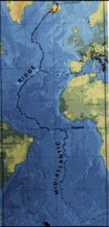
The Mid-Atlantic Ridge (MAR) is a mid-ocean ridge, a divergent tectonic plate or constructive plate boundary located along the floor of the Atlantic Ocean, and part of the longest mountain range in the world. In the North Atlantic it separates the Eurasian and North American plates, and in the South Atlantic it separates the African and South American plates. The ridge extends from a junction with the Gakkel Ridge northeast of Greenland southward to the Bouvet Triple Junction in the South Atlantic. Although the Mid-Atlantic Ridge is mostly an underwater feature, portions of it have enough elevation to extend above sea level. The section of the ridge that includes Iceland is known as the Reykjanes Ridge. The ridge has an average spreading rate of about 2.5 centimetres (0.98 in) per year.

Grenadines is an administrative parish of Saint Vincent and the Grenadines, comprising the islands of the Grenadines other than those belonging to Grenada. The capital is Port Elizabeth.

Morant Cays is an offshore island group 51 km SSE off Morant Point, Jamaica. They are one of two offshore island groups belonging to Jamaica, the other ones being the Pedro Cays. They are located at 17°24′N75°59′W and consist of four small islets grouped closely together along the southeastern rim of Morant Bank a comparatively extensive crescent-shaped bank of coral, over 7 km long, rising from 1000 m. The area of Morant Bank is about 100 km². The aggregate land area of the four cays is only 16.0 hectares or 39.5 acres. Morant Cays are low-lying, mostly uninhabited, seasonally visited by fishermen, and fronted by highly exposed reefs over which the sea constantly breaks. The islands have sparse vegetation and are a seabird rookery and turtle nesting area.

Kunbaracs is a village in Bács-Kiskun county, in the district of Kecskemét city, in the Southern Great Plain region of southern Hungary. As of 2015, its population was 618, which makes it the smallest settlement in this area.
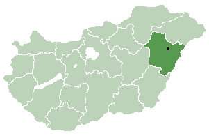
Álmosd is a village in Hajdú-Bihar county, in the Northern Great Plain region of eastern Hungary.

Pampliega is a municipality and town located in the province of Burgos, Castile and León, Spain. According to the 2005 census (INE), the municipality has a population of 395 inhabitants.
Palazuelos de Muñó is a municipality and town located in the province of Burgos, Castile and León, Spain. According to the 2004 census (INE), the municipality has a population of 65 inhabitants.
Trioen Nunataks is an isolated group of three nunataks about 8 miles (13 km) northwest of Borg Mountain in Queen Maud Land. Mapped by Norwegian cartographers from surveys and air photos by the Norwegian-British-Swedish Antarctic Expedition (NBSAE) (1949–1952), led by John Schjelderup Giæver and named Trioen.
Lanfiéra is a village in the Solenzo Department of Banwa Province in western Burkina Faso. As of 2005 it had a population of 617.

The Ossau Valley is a valley of the French Pyrénées, in the Pyrénées-Atlantiques département.

Boula is a town and sub-prefecture in the Kankan Prefecture in the Kankan Region of eastern Guinea. As of 2014 it had a population of 15,763 people.
Dolna Krushitsa is a village in Petrich Municipality, in Blagoevgrad Province, Bulgaria.
Ritya postcode 5370 is a village in Dryanovo Municipality, in Gabrovo Province, in northern central Bulgaria.
Üüvere is a village in Saaremaa Parish, Saare County in western Estonia.

Sulice (Srebrenica) is a village in the municipality of Srebrenica, Bosnia and Herzegovina.

Nobby Nunatak is a nunatak, 270 m, standing 1 nautical mile (1.9 km) south of Lake Boeckella and 1 nautical mile (1.9 km) east of Mount Flora, at the northeast end of Antarctic Peninsula.

Točná Airport is a private domestic airport in Točná, Prague 12 in the Czech Republic.


