
Aust-Agder was a county (fylke) in Norway until 1 January 2020, when it was merged with Vest-Agder to form Agder county. In 2002, there were 102,945 inhabitants, which was 2.2% of Norway's population. Its area was 9,212 square kilometres (3,557 sq mi). The county's administrative center was the town of Arendal.

Åseral is a municipality in Agder county, Norway. It is in the traditional district of Sørlandet. The administrative centre of the municipality is the village of Kyrkjebygda. Other villages in Åseral include Eikerapen, Kylland, Ljosland, and Åknes.

Froland is a municipality in Agder county, Norway. It is part of the traditional region of Sørlandet. The administrative center is the village of Blakstad, which along with Osedalen form the main population center of the municipality. Other villages in Froland include Bøylefoss, Bøylestad, Froland, Frolands verk, Heldalsmo, Hinnebu, Hynnekleiv, Jomås, Lauvrak, Libru, Løvjomås, Mjåvatn, Mjølhus, Mykland, and Risdal.

Bygland is a municipality in Agder county, Norway. It is located in the traditional district of Setesdal. The administrative centre of the municipality is the village of Bygland. Other villages in the municipality include Åraksbø, Austad, Byglandsfjord, Grendi, Langeid, Lauvdal, Litveit, Longerak, Moi, Ose, Sandnes, Skåmedal, and Tveit. The Norwegian National Road 9 runs through the municipality, following the river Otra where most of the population of Bygland lives.

Valle is a municipality in Agder county, Norway. It is located in the traditional district of Setesdal. The administrative centre of the municipality is the village of Valle. Other villages in Valle include Besteland, Brokke, Homme, Hovet, Rygnestad, Rysstad, and Uppstad.
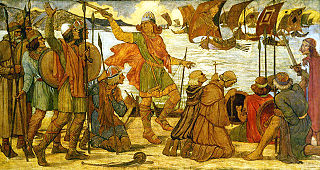
Knowledge about military technology of the Viking Age is based on relatively sparse archaeological finds, pictorial representation, and to some extent on the accounts in the Norse sagas and laws recorded in the 14th century.

Byglandsfjord is a village in Bygland municipality in Agder county, Norway. The village is located in the Setesdal valley along the Norwegian National Road 9 and the river Otra in the far southern part of the municipality, just north of the border with Evje og Hornnes municipality and at the southern end of the lake Byglandsfjorden. The 0.47-square-kilometre (120-acre) village has a population (2016) of 365 which gives the village a population density of 777 inhabitants per square kilometre (2,010/sq mi). Revsnes Hotel offers accommodation.
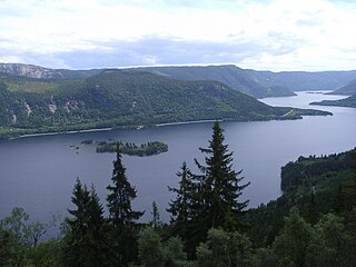
Åraksfjorden is a lake in the municipality of Bygland in Agder county, Norway. The 11.96-square-kilometre (4.62 sq mi) lake is part of the Otra drainage basin. The northern part of the lake is fed directly by the river Otra. The southern part of the lake goes through a narrow channel which leads into the Byglandsfjorden. The villages of Frøysnes and Skåmedal are located along the western side of the lake and on the eastern side are the villages of Sandnes and Åraksbø. The Norwegian National Road 9 runs along the eastern side of the lake.
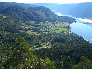
Byglandsfjorden is a lake in Agder county, Norway. The 32.79-square-kilometre (12.66 sq mi) lake lies on the river Otra, primarily in the municipality of Bygland, but the far southern tip of the lake extends into the neighboring municipality of Evje og Hornnes. The river flows out of the lake Åraksfjorden to the north and into the Byglandsfjorden through a narrow channel, and the southern end of the Byglandsfjorden is marked by a dam along the river. The villages of Byglandsfjord, Grendi, Longerak, Lauvdal, and Bygland are all located on the eastern shore of the lake along the Norwegian National Road 9. The western shore of the lake is much more sparsely populated, with County Road 304 following that shoreline.
Lauvdal is a village in the municipality of Bygland in Agder county, Norway. It's located along the Norwegian National Road 9 on the east side of Byglandsfjorden. The village lies about 6 kilometres (3.7 mi) south of the village of Bygland and about the same distance north of the village of Longerak. The population (2001) was 41 residents. The lake Longerakvatnet is located about 6 kilometres (3.7 mi) southeast of the village.
Grendi is a village in Bygland municipality in Agder county, Norway. The village is located on the east side of the lake Byglandsfjorden in the south part of the municipality. Grendi sits along the Norwegian National Road 9 about 5 kilometres (3.1 mi) north of the village of Byglandsfjorden and about 6 kilometres (3.7 mi) south of the village of Longerak. Årdal Church is located in the village. In the early 1900s, a tuberculosis sanatorium was established in Grendi.
Longerak is a village in Bygland municipality in Agder county, Norway. The village is located on the eastern shore of the lake Byglandsfjorden. The village sits along the Norwegian National Road 9, about 7 kilometres (4.3 mi) north of the village of Grendi and about 6 kilometres (3.7 mi) south of Lauvdal. The village of Frøyrak lies about 2 kilometres (1.2 mi) to the west on the other side of the lake. The lake Longerakvatnet lies about 2.5 kilometres (1.6 mi) to the east, high up in the mountains above the village. The water from the lake is used in the Longerak power station to produce hydroelectric power.
Moi is a village in Bygland municipality in Agder county, Norway. The village is located on the west shore of the river Otra, about 1.5 kilometres (0.93 mi) north of the village of Ose and about 5 kilometres (3.1 mi) southeast of the village of Tveit, along the Norwegian National Road 9.

Ose is a village in Bygland municipality in Agder county, Norway. The village is located along the river Otra, just north of the lake Åraksfjorden. The Norwegian National Road 9 runs through the village. Just across the river to the north lies the village of Austad, and about 1.5 kilometres (0.93 mi) to the north along Highway 9 lies the village of Moi.

Sandnes is a village in Bygland municipality in Agder county, Norway. The village is located on a small flat area between the lake Åraksfjorden to the west and the steep mountainside to the east. The county road 323 runs through the village on its way to the larger village of Åraksbø, about 5 kilometres (3.1 mi) to the north. The small village had about 80 residents in 1845, but in 2009, there were only 12 residents living here. The village of Skåmedal lies about 2 kilometres (1.2 mi) to the southwest, across the lake.
Skåmedal is a village in Bygland municipality in Agder county, Norway. The village is located along the southwestern shore of the Åraksfjorden, about 2 kilometres (1.2 mi) southwest of the village of Sandnes, across the lake. Skåmedal sits along the Norwegian National Road 9, about 9 kilometres (5.6 mi) northwest of the village of Bygland and about 10 kilometres (6.2 mi) south of the village of Ose.

Årdal Church is a parish church of the Church of Norway in Bygland Municipality in Agder county, Norway. It is located in the village of Grendi, just west of the Norwegian National Road 9, on the shore of the Byglandsfjorden. It is one of the churches for the Bygland og Årdal parish which is part of the Otredal prosti (deanery) in the Diocese of Agder og Telemark. The white, wooden church was built in a octagonal design in 1828 by Anders Thorsen Syrtveit who used plans drawn up by the architect Hans Linstow. The church seats about 200 people.
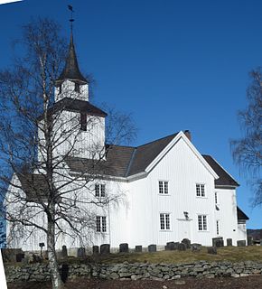
Bygland Church is a parish church of the Church of Norway in Bygland Municipality in Agder county, Norway. It is located in the village of Bygland on the eastern shore of the Byglandsfjorden, just alongside the Norwegian National Road 9. It is one of the churches for the Bygland og Årdal parish which is part of the Otredal prosti (deanery) in the Diocese of Agder og Telemark. The white, wooden church was built in a cruciform design in 1838 by the builder Anders Thorsen Syrtveit who used plans drawn up by the famous architect Hans Linstow. The church seats about 250 people.
Bygland is the administrative centre of Bygland municipality in Agder county, Norway. The village is located on the eastern shore of the lake Byglandsfjorden, near the northern end of the lake. The village lies along the Norwegian National Road 9, about 6 kilometres (3.7 mi) north of the village of Lauvdal and about 8 kilometres (5.0 mi) southeast of the village of Skåmedal. The village is the site of the municipal government, old-age home, medical clinic, and Bygland Church. There is a private Christian high school, KVS Bygland, that is located in this village.
Tveit is a village in Bygland municipality in Agder county, Norway. The village is located on the south shore of the river Otra, about halfway between the villages of Langeid and Moi along the Norwegian National Road 9. The village is the present site of Austad Church which serves the northern part of the municipality. Prior to 1880, Austad Church was located in the nearby village of Austad on the other side of the river.

