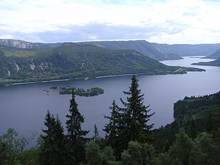
Øyarvatnet or Øyarvatn is a lake in Norway. It sits on the border between the municipalities of Valle in Aust-Agder county and Sirdal in Vest-Agder county, about 30 kilometres (19 mi) northeast of the village of Lunde, Sirdal and about 32 kilometres (20 mi) west of Austad in Bygland. The lake is part of the Kvina river system. It is located just to the south of the lake Rosskreppfjorden, which flows into it. The dam at the south end of the 8.05-square-kilometre (3.11 sq mi) lake keeps it at an elevation of 837 metres (2,746 ft).

Longerakvatnet or Longeraksvatnet is a lake in the municipality of Bygland in Aust-Agder county, Norway. It has a small dam on the southwest side to regulate the water level for hydro-electric power generation at a plant located down the hill. The lake discharges into the Longeraksåni river which flows into the Byglandsfjorden near the village of Longerak. The 3.4-square-kilometre (1.3 sq mi) lake is located about 6 kilometres (3.7 mi) southeast of the village of Lauvdal and about 10 kilometres (6.2 mi) northeast of the village of Byglandsfjord.

Kvifjorden is a lake in Norway that straddles the borders of the municipalities of Sirdal and Kvinesdal in Vest-Agder county and Bygland in Aust-Agder county. The lake was created when a dam was built along the Kvina river.

Byglandsfjorden is a lake in Aust-Agder county, Norway. The 32.79-square-kilometre (12.66 sq mi) lake lies on the river Otra, primarily in the municipality of Bygland, but the far southern tip of the lake extends into the neighboring municipality of Evje og Hornnes. The river flows out of the lake Åraksfjorden to the north and into the Byglandsfjorden through a narrow channel, and the southern end of the Byglandsfjorden is marked by a dam along the river. The villages of Byglandsfjord, Grendi, Longerak, Lauvdal, and Bygland are all located on the eastern shore of the lake along the Norwegian National Road 9. The western shore of the lake is much more sparsely populated, with County Road 304 following that shoreline.

Austad is a village in Bygland municipality in Aust-Agder county, Norway. The village is located on the eastern shore of the river Otra, just north of the lake Åraksfjorden. The village of Ose lies just to the south, across the river. The area is flat, wedged between the river and the mountains to the east. The village area is mostly used as farmland.

Grendi is a village in Bygland municipality in Aust-Agder county, Norway. The village is located on the east side of the lake Byglandsfjorden in the south part of the municipality. Grendi sits along the Norwegian National Road 9 about 5 kilometres (3.1 mi) north of the village of Byglandsfjorden and about 6 kilometres (3.7 mi) south of the village of Longerak. Årdal Church is located in the village. In the early 1900s, a tuberculosis sanatorium was established in Grendi.

Langeid is a village in Bygland municipality in Aust-Agder county, Norway. The village is located in the northern part of the municipality, along the river Otra and the Norwegian National Road 9, about halfway between the villages of Tveit and Besteland.

Moi is a village in Bygland municipality in Aust-Agder county, Norway. The village is located on the west shore of the river Otra, about 1.5 kilometres (0.93 mi) north of the village of Ose and about 5 kilometres (3.1 mi) southeast of the village of Tveit, along the Norwegian National Road 9.

Ose is a village in Bygland municipality in Aust-Agder county, Norway. The village is located along the river Otra, just north of the lake Åraksfjorden. The Norwegian National Road 9 runs through the village. Just across the river to the north lies the village of Austad, and about 1.5 kilometres (0.93 mi) to the north along Highway 9 lies the village of Moi.
Austad Church may refer to:
Tveit Church may refer to:

Bygland Church is a parish church in Bygland municipality in Aust-Agder county, Norway. It is located in the village of Bygland on the eastern shore of the Byglandsfjorden, just alongside the Norwegian National Road 9. The church is part of the Bygland parish in the Otredal deanery in the Diocese of Agder og Telemark. The white, wooden church was built in a cruciform style in 1838 by the builder Anders Thorsen Syrtveit who used plans by the famous architect Hans Linstow. The church seats about 250 people. The church was consecrated on 18 November 1838 by the local Dean Ole Berg from Evje Church.

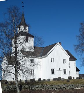
Austad Church is a parish church in Bygland municipality in Aust-Agder county, Norway. It is located in the village of Tveit on the south shore of the river Otra, just off the Norwegian National Road 9. The church is part of the Bygland parish in the Otredal deanery in the Diocese of Agder og Telemark. The white, wooden church was built in a rectangular style in 1880 by the architect Oskar Fabricius from Oslo. The church seats about 250 people. It was consecrated on 7 July 1880 by the Bishop Jørgen Moe. This church was built to replace a much older Austad Church that was located in Austad, about 5 kilometres (3.1 mi) to the southeast, on the other side of the river. The old church was torn down around the same time as the present church was built.

Bygland is the administrative centre of Bygland municipality in Aust-Agder county, Norway. The village is located on the eastern shore of the lake Byglandsfjorden, near the northern end of the lake. The village lies along the Norwegian National Road 9, about 6 kilometres (3.7 mi) north of the village of Lauvdal and about 8 kilometres (5.0 mi) southeast of the village of Skåmedal. The village is the site of the municipal government, old-age home, medical clinic, and Bygland Church. There is a private Christian high school, KVS Bygland, that is located in this village.


