
The Kai Islands of Indonesia are a group of islands in the southeastern part of the Maluku Islands, located in the province of Maluku. The Moluccas have been known as the Spice Islands due to regionally specific plants such as nutmeg, mace, and cloves that originally intrigued the European nations of the 16th century. The coastal zone of the islands are identified as a site of highest marine biodiversity importance in the Coral Triangle.
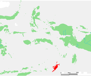
The Tanimbar Islands, also called Timur Laut, are a group of about 65 islands in the Maluku province of Indonesia. The largest and most central of the islands is Yamdena; others include Selaru to the southwest of Yamdena, Larat and Fordata to the northeast, Maru and Molu to the north, and Seira, Wuliaru, Selu, Wotap and Makasar to the west. The Indonesian phrase timur laut means "east of the sea" or "northeast".
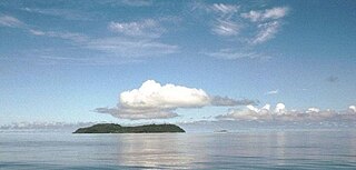
The Banda Sea is one of four seas that surround the Maluku Islands of Indonesia, connected to the Pacific Ocean, but surrounded by hundreds of islands, including Timor, as well as the Halmahera and Ceram Seas. It is about 1000 km (600 mi) east to west, and about 500 km (300 mi) north to south.
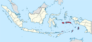
Maluku is a province of Indonesia. It comprises the central and southern regions of the Maluku Islands. The largest city and capital of Maluku province is Ambon on the small Ambon Island. It is directly adjacent to North Maluku, Southwest Papua, and West Papua in the north, Central Sulawesi, and Southeast Sulawesi in the west, Banda Sea, Australia, East Timor and East Nusa Tenggara in the south and Arafura Sea, Central Papua and South Papua in the east. The land area is 57803.81 km2, and the total population of this province at the 2010 census was 1,533,506 people, rising to 1,848,923 at the 2020 census, the official estimate as at mid 2023 was 1,908,753. Maluku is located in Eastern Indonesia.

The Arafura Sea lies west of the Pacific Ocean, overlying the continental shelf between Australia and Western New Guinea, which is the Indonesian part of the Island of New Guinea.
Yamdena is the largest of the Tanimbar Islands in the Maluku province of Indonesia. Saumlaki is the chief town, located on the south end of the island.
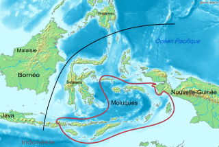
The Central Malayo-Polynesian languages (CMP) are a proposed branch in the Malayo-Polynesian subgroup of the Austronesian language family. The languages are spoken in the Lesser Sunda and Maluku Islands of the Banda Sea, in an area corresponding closely to the Indonesian provinces of East Nusa Tenggara and Maluku and the nation of East Timor, but with the Bima language extending to the eastern half of Sumbawa Island in the province of West Nusa Tenggara and the Sula languages of the Sula archipelago in the southwest corner of the province of North Maluku. The principal islands in this region are Sumbawa, Sumba, Flores, Timor, Buru, and Seram. The numerically most important languages are Bima, Manggarai of western Flores, Uab Meto of West Timor, and Tetum, the national language of East Timor.

Moyo is an island off the north coast of Sumbawa Island, in Sumbawa Regency, West Nusa Tenggara province, Indonesia.

Selaru is an island in Indonesia in the Tanimbar Islands group, Southeast Maluku. It is located south of Yamdena. It is one of the 92 officially listed outlying islands of Indonesia.

The Banda Sea Islands moist deciduous forests is a tropical moist forest ecoregion in Indonesia. The ecoregion includes several island groups in the southwestern Banda Sea, including the Tanimbar Islands, Kai Islands, and the Barat Daya Islands except for Wetar.

Moluccans are the Austronesian-speaking and Papuan-speaking ethnic groups indigenous to the Maluku Islands, Eastern Indonesia. The region was historically known as the Spice Islands, and today consists of two Indonesian provinces of Maluku and North Maluku. As such, "Moluccans" is used as a blanket term for the various ethnic and linguistic groups native to the islands.
The Kei–Tanimbar languages are a small group of Austronesian languages spoken on the Kei and Tanimbar islands in the southern Maluku Islands, and on the north side of the Bomberai Peninsula. The languages include:

Southeast Maluku Regency is a regency of Maluku, Indonesia. It is coincident with the Kei Islands, except that the city of Tual, although within the Kei Islands geographically and the seat of the Regency's administration, is since 17 July 2007 technically independent of the Regency. The land area of the Regency is 1,031.01 km2, while the sea area administered by the Regency was 3,181 km2; it had a population of 96,442 at the 2010 Census; this increased to 121,511 at the 2020 Census, and the official estimate as at mid 2023 was 129,034.

Tanimbar Islands Regency is a regency of Maluku province, Indonesia, consisting primarily of the Tanimbar Islands. The Regency covers a land area of 10,102 km2, and it had a population of 105,341 at the 2010 Census and 123,572 at the 2020 Census; the official estimate as at mid 2022 was 124,787. The principal town and administrative centre lies at Saumlaki in Tanimbar Selatan District.

Troides staudingeri is a birdwing butterfly in the genus Troides in the family Papilionidae. It is known from Leti Island, Moa Island, Kisar Island, Babar Island and Wetar Island.
Selaru is an Austronesian language of Selaru and Yamdena, in the Maluku Islands of Indonesia. Linguistically it is not close to Seluwasan, its nearest relative.

Saumlaki is a town in Tanimbar Islands Regency, Indonesia. It is the seat of Tanimbar Islands Regency, as well as the biggest town in the island of Yamdena. Previously a small village, it has grown to a relatively sizeable town due to its political status as a regency seat. Most of the regency's infrastructure is concentrated in Saumlaki. The administrative location of the town is in the kelurahan of Saumlaki, inside South Tanimbar District. The urban settlement extends outside of the administrative boundaries to surrounding communities such as the villages of Olilit and Sifnana.
The Tanimbar monitor is a species of monitor lizard native to the Tanimbar archipelago of Maluku, Indonesia. It was first described in 2023 using specimens that were preserved at the Western Australian Museum. Another species of Varanus, the Louisiade monitor, was described in the same study.


