Related Research Articles

Swarzędz is a town in west-central Poland with 29,766 inhabitants. It is the seat of a mixed urban-rural commune called Gmina Swarzędz with 40,166 inhabitants. The town is situated in the Poznań metropolitan area, in the Greater Poland Voivodeship, having previously been in Poznań Voivodeship (1975–1998).

Pruszków is a city in east-central Poland, situated in the Masovian Voivodeship since 1999. It was previously in Warszawa Voivodeship (1975–1998). Pruszków is the capital of Pruszków County, located along the western edge of the Warsaw urban area.
Gostyń is a town in western Poland, seat of the Gostyń County and Gmina Gostyń in the Greater Poland Voivodeship. According to 30 June 2004 data its population was 20,746.
Maladzyechna or Molodechno is a town in Minsk Region, Belarus. It serves as the administrative centre of Maladzyechna District. Maladzyechna is located 72 kilometres (45 mi) northwest of Minsk. In 2006, it had an estimated population of 98,514 inhabitants. As of 2023, it has a population of 89,268.
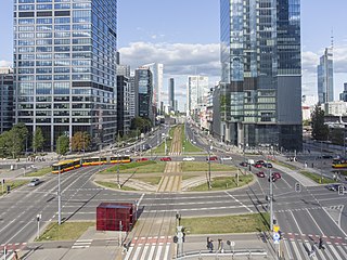
Wola is a district in western Warsaw, Poland. An industrial area with traditions reaching back to the early 19th century, it underwent a transformation into a major financial district, featuring various landmarks and some of the tallest office buildings in the city.
Grójec is a town in eastern Poland, located in the Masovian Voivodeship, about 40 kilometres south of Warsaw. It is the capital of the urban-rural administrative district Grójec and Grójec County. It has 16,674 inhabitants (2017). Grójec surroundings are considered to be the biggest apple-growing area of Poland. It is said that the region makes up also for the biggest apple orchard of Europe. Statistically, every third apple sold in Poland is grown in Grójec – a unique local microclimate provides for their beautiful red colour.

In Poland, the resistance movement during World War II was led by the Home Army. The Polish resistance is notable among others for disrupting German supply lines to the Eastern Front, and providing intelligence reports to the British intelligence agencies. It was a part of the Polish Underground State.

Zakroczym is a small town in the Masovian Voivodeship, Poland. It is located at around 52°26′16″N20°36′43″E. The Vistula River flows through the town. Zakroczym has a long and rich history: in the Kingdom of Poland and the Polish–Lithuanian Commonwealth, it was the capital of an administrative unit (ziemia), part of Mazovian Voivodeship. Also, Zakroczym was a royal town of the Crown of the Kingdom of Poland. The town lies at the intersection of two main roads - national road 62, and national road 7.

Chełmża, is a town in northern Poland, in the Toruń County, Kuyavian-Pomeranian Voivodeship. It is located at around 53°11′5″N18°36′15″E. It is one of the historic centers of Chełmno Land.

Wawer is one of the districts of Warsaw, located in the south-eastern part of the city. The Vistula river runs along its western border. Wawer became a district of Warsaw on 27 October 2002.

Wesoła is one of the districts of Warsaw, and has been as such since October 27, 2002. Wesoła is located in the south-eastern part of city.
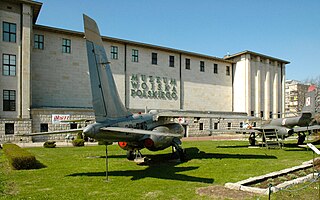
Museum of the Polish Army is a museum in Warsaw documenting the military history of Poland. Established in 1920 under the Second Polish Republic, it occupies a wing of the building of the Polish National Museum as well as several branches in Poland. It is Warsaw's second largest museum and the largest collection of military objects in Poland. The collection illustrates a thousand years of Polish military history, from the 10th century to the Second World War.

Falenica is a part of Wawer, one of districts of Warsaw, located on the right bank of the Vistula, in the far southeastern corner of the city. Until 1951 it was a separate village, then it became part of Warsaw. Before the Second World War Falenica, which is located in a forested area, was a favorite location for summer cottages and houses. Population of around 8.600 inhabitants.

The Wawer massacre refers to the execution of 107 Polish civilians on the night of 26 to 27 December 1939 by the German occupiers of Wawer, Poland. The execution was a response to the killing of two German soldiers in a shootout by two petty criminals. An order to arrest at random any men inhabiting Wawer and the neighboring Anin between the ages of 16 and 70 was given and, as a result, 120 men, who were unrelated to the shootout, were gathered, and a show trial was hastily organized. 114 were declared "guilty" and sentenced to death, the others were spared to bury the dead. In total, 107 were killed and 7 survived, as they withstood the gunfire and were not finished off later.
Fort Beniaminów is a military installation in Beniaminów, some 20 kilometres (12 mi) east of Warsaw. Designed by a Polish-born Russian General Konstanty Wieliczko, the fort was constructed in 1904 as part of the outer ring of defences of the Warsaw Fortress. Conveniently located near the southern bank of Bugonarew, it was to shield the then-Russian city of Warsaw from an enemy force trying to attack it from the East: possibly a German Army trying to outflank the Russian army from East Prussia. It was to cooperate with two earlier forts in Wawer and Kawęczyn and two more modern forts in Pustelniki and Maciołki.

Tarchomin is a neighborhood of Białołęka district, in northern Warsaw, Poland.
Solec is a neighbourhood along the Vistula river in Warsaw, the capital of Poland. It is situated east of Frascati on the southeastern edge of Downtown and south of the Powiśle suburb. Solec was a self governing settlement and town from 1675 until its incorporation into Warsaw in 1791. The name "Solec" is derived from the Polish word for salt – sól – which was extensively traded and transported through the neighbourhood since the late Middle Ages. However, contemporary Solec is mostly occupied by residential tower blocks and commercial buildings.

Kawęczyn-Wygoda is a neighbourhood, and an area of the Municipal Information System, in the city of Warsaw, Poland, located within the district of Rembertów.
Kawęczyn is a neighbourhood, in the city of Warsaw, Poland, located within the district of Rembertów, in the Municipal Information System area of Kawęczyn-Wygoda.

Chrzanów is a residential neighbourhood, and an area of the Municipal Information System, in the city of Warsaw, Poland, located within the district of Bemowo.
References
- ↑ Henryk Wierzchowski (2006). Las. Rolnicze Osiedle Warszawy, 8.
- 1 2 "Mój Wawer. Krzyż Pamięci Pomordowanych Osiedla Las". www.mojwawer.pl (in Polish). Retrieved 2022-12-02.
| | This Warsaw-related location article is a stub. You can help Wikipedia by expanding it. |
| ||