Sadul

Last updated
Sadul
SADUL ulica Chorzowska 01.jpg
Chorzowska Street in Sadul, in 2017.
Sadul
Coordinates: 52°12′33″N21°09′45″E / 52.20917°N 21.16250°E / 52.20917; 21.16250
CountryFlag of Poland.svg  Poland
Voivodeship Masovian
City county Warsaw
District Wawer
Seat110 Lucerny Street, Warsaw
Time zone UTC+1 (CET)
  Summer (DST) UTC+2 (CEST)
Area code +48 22

Sadul is a municipal neighbourhood, and an area of the City Information System, in the city of Warsaw, Poland, located within the district of Wawer. [1] [2]

Contents

The settlement of Sadul was established in 1836, by being separated from the nearby settlement of Zastów. [3] [4] It was incorporated into the city of Warsaw in 1951. [5]

History

Sadul was established in 1836, when it was separated from the settlement of Zastów. Upon its creation, it was leased by Aleksander Stanisław Potocki, owner of Zastów, to Stanisław Łapiński. [3] [4]

In 1909, within current boundaries of the City Information System area of Sadul, was established the holiday village of Anin, which, between 1934 and 1939, had developed into a luxury residential neighborhood. Currently, within the eastern portion of Sadul, is located the neighbourhood of Old Anin. [6] [7]

In 1921, in Sadul was located one household, and the settlement had 5 inhabitants. [4]

From 1867 to 1933, Sadul belonged to the gmina (municipality) of Wawer  [ pl ]. On 9 December 1933, the settlement was transferred to the gmina of Zagóźdź  [ pl ]. On 1 April 1939, the municipality was disestablished, and Sadul was incorporated back into gmina of Wawer. [8]

On 15 May 1951, Sadul, together with the rest of the territory of gmina of Wawer, was incorporated into the city of Warsaw. [5]

On 18 October 2004, the district of Wawer was divided into areas of the City Information System, with Sadul becoming one of them. [1]

Public transit

The Warszawa Anin railway station, located in Sadul, in 2018. Warszawa Anin 2018.jpg
The Warszawa Anin railway station, located in Sadul, in 2018.

In Sadul is located the Warszawa Anin railway station, operated by the Polish State Railways. The station has one platform, and is located at the railway line no. 7. [9]

Location and administrative boundaries

Sadul is located in the city of Warsaw, Poland, within the north-central portion of the district of Wawer. It is a City Information System area. To the north, its border determined by Lucerny Street; to the east, by the railway line no. 7; to the south, by the overhead power lines coming from the Siekierki Power Station; and to the west, by the Zagóźdź Canal, and Nowe Ujście Canal. [1]

It borders Wawer to the north, Anin to the east, Międzylesie to the south, and Zerzeń to the west. [1]

Municipal neighbourhood

Sadul is one of municipal neighbourhoods of the district of Wawer, with its boundaries being identical to the boundaries of the City Information System area of Sadul. It is administrated by the neighbourhood council, which seat of government is located at 110 Lucerny Street. [2]

Related Research Articles

<span class="mw-page-title-main">Kabaty</span> Neighbourhood in Warsaw, Poland

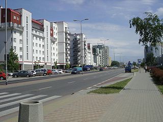
Kabaty is a neighbourhood, and a City Information System area, located in Warsaw, Poland, within the district of Ursynów. It is a residential area dominated by multifamily housing, with a smaller presence of single-family housing as well.

<span class="mw-page-title-main">Pyry, Warsaw</span> Neighbourhood in Warsaw, Poland

Pyry is a municipal neighbourhood, and a City Information System area, in Warsaw, Poland, within the district of Ursynów. It is a residencial area, consisting of single-family housing.

<span class="mw-page-title-main">Stokłosy</span> Neighbourhood in Warsaw, Poland

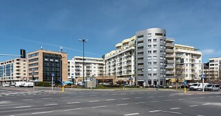
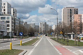
Stokłosy is a neighbourhood in Warsaw, Poland, located within the district of Ursynów, in the City Information System area of North Ursynów. It is a residential area, consisting of the highrise multifamily housing.

<span class="mw-page-title-main">Recław</span> Village in West Pomeranian Voivodeship, Poland

Recław is a village in the West Pomeranian Voivodeship, Poland, located within Gmina Wolin, Kamień County.

<span class="mw-page-title-main">Miedzeszyn</span> Neighbourhood of Warsaw, Poland

Miedzeszyn is a neighbourhood of Wawer, a district of Warsaw, Poland. Until 1951, it was a separate village.

<span class="mw-page-title-main">Jelonki, Warsaw</span> Neighbourhood and City Information System areas in Warsaw, Masovian Voivodeship, Poland

Jelonki, prior to 1951 known as Jelonek, is a residential neighbourhood in the city of Warsaw, Poland, located within the district of Bemowo. The City Information System divides the neighbourhood into two areas, Jelonki Północne and Jelonki Południowe.

<span class="mw-page-title-main">Dąbrówka, Warsaw</span> Neighbourhood in the city of Warsaw, Poland

Dąbrówka [dɔ̃bruvka] is a municipal neighbourhood, and a City Information System area, in Warsaw, Poland, within the district of Ursynów. It is a residencial area, consisting of single-family housing.

<span class="mw-page-title-main">Kawęczyn-Wygoda</span> Neighbourhood in the city of Warsaw, Poland

Kawęczyn-Wygoda is a neighbourhood, and an area of the Municipal Information System, in the city of Warsaw, Poland, located within the district of Rembertów.

<span class="mw-page-title-main">Wiktoryn, Warsaw</span> Neighbourhood of Warsaw, Poland

Wiktoryn is a residential neighbourhood in the city of Warsaw, Poland, located within the district of Włochy, in the City Information System area of Stare Włochy.

<span class="mw-page-title-main">Kępa Zawadowska</span> Neighbourhood of Warsaw, Poland

Kępa Zawadowska is a neighbourhood and a City Information System area in Warsaw, Poland, located within the district of Wilanów.

<span class="mw-page-title-main">Opacz Wielka</span> Neighbourhood of Warsaw, Poland

Opacz Wielka is a neighbourhood, and City Information System area, in the city of Warsaw, Poland. It is a residential area consisting of single-family detached homes.

<span class="mw-page-title-main">Jary, Warsaw</span> Neighbourhood in Warsaw, Poland

Jary is a neighbourhood in Warsaw, Poland, located within the district of Ursynów, in the City Information System of North Ursynów.

<span class="mw-page-title-main">Wyczółki, Warsaw</span> Neighbourhood in Warsaw, Poland

Wyczółki is a neighbourhood, and a City Information System area, located in Warsaw, Poland, within the district of Ursynów. It is a mixed area, consisting of residencial zones, as well as business office complexes and storage warehouses.

<span class="mw-page-title-main">Grabów, Warsaw</span> Neighbourhood in Warsaw, Poland

Grabów is a neighbourhood, and a City Information System area, located in Warsaw, Poland, within the district of Ursynów. It consists mostly of the low-rise residential buildings.

<span class="mw-page-title-main">Krasnowola</span> Neighbourhood in Warsaw, Poland

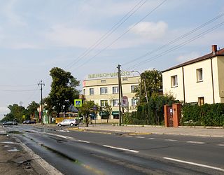
Krasnowola is a neighbourhood in Warsaw, Poland, located within the district of Ursynów, in the City Information System area of Grabów. It is centred around Krasnowolska Street, and mostly consists of single-family detached homes.

<span class="mw-page-title-main">Jeziorki, Warsaw</span> Neighbourhood in Warsaw, Poland

Jeziorki is a municipal neighbourhood in Warsaw, Poland, located within the district of Ursynów. It is encompassed within two areas of the City Information System: Jeziorki Północne and Jeziorki Południowe, and is traditionally divided into two parts: Nowe Jeziorki, and Jeziorki Polskie. The neighbourhood is a residencial area of lowrise single-family housing.

<span class="mw-page-title-main">Ludwinów, Warsaw</span> Neighbourhood in Warsaw, Poland

Ludwinów is a neighbourhood in Warsaw, Poland, within the district of Ursynów. It is part of the municipal neighbourhood of Jeziorki, and the City Information System area of Jeziorki Północne. The neighbourhood consists of lowrise single-family housing.

<span class="mw-page-title-main">Na Skraju</span> Neighbourhood in Warsaw, Poland

Na Skraju is a neighbourhood in Warsaw, Poland, located within the district of Ursynów, in the eastern portion of the City Information System area of Ursynów-Centrum.

<span class="mw-page-title-main">Nadwiśle</span> Neighbourhood of Warsaw, Poland

Nadwiśle is a municipal neighbourhood, and a City Information System area, in Warsaw, Poland, located within the district of Wawer. It is a residencial area of single-family housing.

<span class="mw-page-title-main">Radość, Warsaw</span> Neighbourhood of Warsaw, Poland

Radość is a municipal neighbourhood, and a City Information System area, in Warsaw, Poland, located within the district of Wawer. It is a residencial area of single-family housing.

References

  1. 1 2 3 4 Uchwała nr 104/XXVII/2004 Rady Dzielnicy Wawer m. st. Warszawy z dnia 18 października 2004 r. Warsaw: District Council of Wawer. 18 October 2004. (in Polish)
  2. 1 2 "Osiedle Sadul". wawer.um.warszawa.pl (in Polish).
  3. 1 2 Kontrakt z Stanisławem Łapińskim o Kolonię Sadul. 1837. In: Księga gruntowa obejmująca kontrakty z kollonistami i czynszownikami w Dobrach Wilanowskich. (in Polish).
  4. 1 2 3 Niezwykly Wawer. Przewodnik turystyczny . Warsaw: Wawer District City Hall. p. 23. ISBN 978-83-7642-964-9. (in Polish).
  5. 1 2 Rozporządzenie Rady Ministrów z dnia 5 maja 1951 r. w sprawie zmiany granic miasta stołecznego Warszawy. 5 May 1951. In: Dzienik Ustaw z 1951 roku, no. 27, position 199. Warsaw. 1951. (in Polish)
  6. Niezwykly Wawer. Przewodnik turystyczny . Warsaw: Wawer District City Hall. p. 13-14. ISBN 978-83-7642-964-9. (in Polish).
  7. "Państwowy Rejestr Nazw Geograficznych - miejscowości - format XLSX". dane.gov.pl (in Polish).
  8. Rozporządzenie Ministra Spraw Wewnętrznych z dnia 27 marca 1939 r. o utworzeniu gminy wiejskiej Sulejówek, zniesieniu gminy wiejskiej Zagóżdż i o zmianie granic niektórych gmin wiejskich w powiecie i województwie warszawskim. . 27 March 1939. In: Dzienik Ustaw z 1939 roku, no. 28, position 188. Warsaw. 1939. (in Polish)
  9. "Warszawa Anin". bazakolejowa.pl (in Polish).