
Sonora, officially Estado Libre y Soberano de Sonora, is one of the 31 states which, along with Mexico City, comprise the Federal Entities of Mexico. The state is divided into 72 municipalities; the capital city of which being Hermosillo, located in the center of the state. Other large cities include Ciudad Obregón, Nogales, San Luis Río Colorado, and Navojoa.

Puerto Vallarta is a Mexican beach resort city on the Pacific Ocean's Bahía de Banderas in the Mexican state of Jalisco. Puerto Vallarta is the second largest urban agglomeration in the state after the Guadalajara Metropolitan Area. The City of Puerto Vallarta is the government seat of the Municipality of Puerto Vallarta, which comprises the city as well as population centers outside of the city extending from Boca de Tomatlán to the Nayarit border. The city is located at 20°40′N105°16′W. The municipality has an area of 681 square kilometres (262.9 sq mi). To the north, it borders the southwest of the state of Nayarit. To the east, it borders the municipality of Mascota and San Sebastián del Oeste, and to the south, it borders the municipalities of Talpa de Allende and Cabo Corrientes.

Playa del Carmen, known colloquially as 'Playa', is a resort city located along the Caribbean Sea in the state of Quintana Roo, Mexico. It is part of the municipality of Solidaridad. As of 2020, the city's population was just over 300,000 people during 2020, a small yet thriving portion of which are foreign immigrants.

Mazatlán is a city in the Mexican state of Sinaloa. The city serves as the municipal seat for the surrounding municipio, known as the Mazatlán Municipality. It is located on the Pacific coast across from the southernmost tip of the Baja California Peninsula.
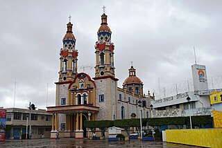
Huatabampo is a city in Huatabampo Municipality in the state of Sonora, in northwestern Mexico. It is situated on the Gulf of California, near the mouth of the Mayo River. It is located at latitude 26°49′N109°40′W. Huatabampo is 34 km (21 mi) southwest of Navojoa via Sonora State Highway 56 and Sonora State Highway 149. Mexican Federal Highway 15 can be accessed via Sonora State Highway 176. It is notable as the home of revolutionary general Álvaro Obregón, a successful chickpea farmer before the Mexican Revolution, and now his burial site.

Puerto Peñasco is a small city located in Puerto Peñasco Municipality in the northwest of the Mexican state of Sonora, 100 kilometres (62 mi) from the border with the U.S. state of Arizona. According to the 2020 census, it has a population of 62,689 inhabitants. It is located on the northern shores of the Sea of Cortez on the small strip of land that joins the Baja California Peninsula with the rest of Mexico. The area is part of the Altar Desert, one of the driest and hottest areas of the larger Sonoran Desert.
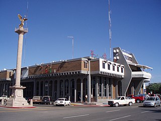
Navojoa is the fifth-largest city in the northern Mexican state of Sonora and is situated in the southern part of the state. The city is the administrative seat of Navojoa Municipality, located in the Mayo River Valley.

The Riviera Maya is a tourism and resort district south of Cancun, Mexico. It straddles the coastal Federal Highway 307, along the Caribbean coastline of the state of Quintana Roo, located in the eastern portion of the Yucatán Peninsula. Originally the name applied narrowly, focusing on the area of coastline between the city of Playa del Carmen and Tulum. The designation has since expanded up and down the coast, now including the towns of Puerto Morelos, situated to the north of Playa del Carmen, as well as the town of Felipe Carrillo Puerto, situated 40 km (25 mi) to the south of Tulum. This larger region is what is currently being promoted as part of the Riviera Maya tourist corridor.
Huatulco, formally Bahías de Huatulco, centered on the town of La Crucecita, is a tourist development in Mexico. It is located on the Pacific coast in the state of Oaxaca. Huatulco's tourism industry is centered on its nine bays, thus the name Bahías de Huatulco, but has since been unofficially shortened to simply Huatulco. Huatulco has a wide variety of accommodation from rooms for rent, small economy hotels, luxury villas, vacation condominia, bed and breakfasts, as well as several luxury resorts standing on or near the shores of Tangolunda Bay. The Camino Real Zaashila, Quinta Real Huatulco, Las Brisas, Dreams Resort & Spa, and the Barceló are examples of the most popular larger resorts in the area.

Puerto La Cruz is a port city located in Anzoátegui State, in Venezuela. It is the seat of the Juan Antonio Sotillo Municipality. The city has road connections to the state capital, Barcelona, to Lecheria and to Guanta.

The Asia District is one of 16 that make up the Peruvian province of Cañete. Founded by Beinto Chumpitaz Chavez on July 24, 1964, it was originally part of the Coayllo District.

The Mayo or Yoreme are an Indigenous group in Mexico, living in the northern states of southern Sonora, northern Sinaloa and small settlements in Durango.
San Agustinillo is a small fishing village and beach in the state of Oaxaca, Mexico. It is located in the municipality of Santa María Tonameca just east of the coastal communities of Mazunte and La Ventanilla. This is where the Sierra Madre del Sur mountains meet the Pacific Ocean.

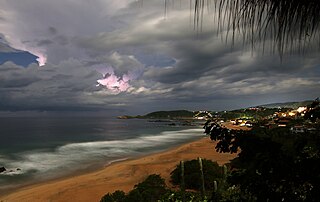
Chacala is a beach town set in small cove on the Pacific coast of Mexico in the State of Nayarit. It is located near pueblo Las Varas, about 100 kilometers (62 mi) north of Puerto Vallarta, and is part of the coastline known as the Riviera Nayarita. The name means "where there are shrimp" in Náhuatl. The population consists of approximately 300 full-time residents but can swell to over 1000 during Mexico's most popular vacation periods, such as Semana Santa and Christmas. Chacala is known for its physical beauty and unhurried lifestyle.
Navojoa National Airport is an airfield located 8 kilometres (5.0 mi) south of Navojoa, Sonora, Mexico. It serves domestic air traffic for the city of Navojoa, supporting general aviation activities. It does not provide scheduled passenger public flights. The nearest airport that serves commercial flights is Ciudad Obregon International Airport.

Puerto Ángel is a small coastal town in the Mexican state of Oaxaca located in the municipality of San Pedro Pochutla. It, along with San Agustinillo and Playa Zipolite are known as the "Riviera Oaxaqueña". It is located 9 km south of city of Pochutla approximately 50 kilometers west of Huatulco and 80 kilometers east of Puerto Escondido. Despite tourism development since the 1960s, the town is still mostly a fishing village, located on a small bay surrounded by rocky hills that lead into the Sierra Madre del Sur. It was founded in the mid-19th century as a port for the region's coffee and lumber industries but since then other means of shipping these products has replaced it.
Paraíso is a town and municipality located in the north of the Mexican state of Tabasco, about 75 km due north of the state capital of Villahermosa on the Gulf of Mexico. Much of the area is traditionally dedicated to fishing and agriculture. Today, it is also an oil-producing area with the mostly oil-dedicated port of Dos Bocas. There is also some tourism connected to the area's beaches and natural attractions, and the area is promoted under the state's Cacao Route tourism program.
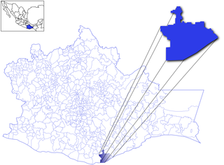
Navojoa Municipality is a municipality in the Mexican state of Sonora in north-western Mexico. As of 2015, the municipality had a total population of 163,650.

Puerto Arista is a small community and tourist attraction located on the north coast of Chiapas, Mexico in the municipality of Tonalá. While it originally was a port, its lack of harbor and suitability for large cargo ships eventually shifted the economy to tourism in the 20th century. It is popular with people from Chiapas as it is located close to the state capital of Tuxtla Gutiérrez as well as the regional city of Tonalá. It is the most visited beach in Chiapas and one of its most popular tourist destinations, despite its relative lack of sophisticated tourism infrastructure. Puerto Arista is home of one of the state’s four marine turtle sanctuaries, design to help protect the various species which come here to lay their eggs.


