In 2010, Las Casas had a population of 6,399 and a population density of 20,641.9 persons per square mile.[1]
Features
Centro Comunitario Península de Cantera is a community and recreational center located in Las Casas.[4]
Camp Las Casas US Army installation
Regiment training in 1904 in Las Casas
The area of "Las Casas" was also where the United States Army established Camp Las Casas, a military installation established in 1904. The camp was the main training base of the "Porto Rico Regiment of Infantry". On January 15, 1899, the military government changed the name of Puerto Rico to Porto Rico. (On May 17, 1932, U.S. Congress changed the name back to "Puerto Rico"). The Porto Rico Regiment of Infantry was a U.S. Army Regiment which was later renamed the "65th Infantry Regiment". The base continued in operation until 1946, when it was finally closed and the Residencial Las Casas was built in its place.[5]
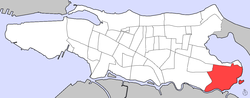
Location
Las Casas is surrounded by two bodies of water, San José Lagoon on the east, and Los Corozos Lagoon on the north. There's also a small islet on the east, Guachinanga Island. To the north of Las Casas is Barrio Obrero.
This page is based on this Wikipedia article Text is available under the CC BY-SA 4.0 license; additional terms may apply. Images, videos and audio are available under their respective licenses.