
Chacao is one of the five political and administrative subdivisions of the city of Caracas, Venezuela. The other four are Baruta, El Hatillo, Libertador and Sucre. This legal entity is known as the Caracas Metropolitan District. Chacao is also one of the 21 municipalities that make up the State of Miranda, Venezuela.

Valera is a city in Trujillo State in Venezuela, situated between the rivers Momboy and Motatán. The current mayor is José Karkom, who has had that post since 2013. The city is home to Italian, Portuguese, Chinese, Colombian and Spanish communities. It is also home to the Universidad Valle del Momboy, a private university, as well as the Instituto Universitario de Tecnología de Trujillo (IUTET). Also, the Universidad Nacional Experimental Simón Rodríguez (UNESR), the Universidad Pedagógica Experimental Libertador (UPEL), among others.
Altamira is a neighborhood located in the Chacao municipality of Caracas, Venezuela. It has its own Metro Station, many hotels and restaurants, and it is an important business and residential center of the city. It is also an important tourist destination and cultural center in Caracas. The Francisco de Miranda avenue and the Distibuidor Altamira are both located in Altamira. This neighborhood borders El Ávila National Park to the north, La Castellana neighborhood to the west, Los Palos Grandes to the east, and Bello Campo neighborhood to the south.

Municipalities of Venezuela are subdivisions of the States of Venezuela. There are 335 municipalities dividing the 23 states and Capital District.

El Hatillo Municipality is an administrative division of the State of Miranda, Venezuela; along with Baruta, Chacao, Libertador and Sucre, it is one of the five municipalities of Caracas, the capital of Venezuela. It is located in the southeastern area of Caracas, and in the northwestern part of the State of Miranda.

The Libertador Bolivarian Municipality is the only administrative division of the Capital District and along with the municipalities of Baruta, Chacao, El Hatillo and Sucre forms the Metropolitan District of Caracas. It is landlocked by Vargas State and also borders Miranda State on the east and south. The municipality is one of a number in Venezuela named "Libertador Municipality", in honour of Venezuelan independence hero Simón Bolívar.
Caricuao is a district of Caracas, Venezuela. It is part of Libertador municipality.

Centro Sambil Caracas, located in Caracas, Venezuela, is the sixth largest shopping mall in South America. It was completed in 1998 and has over 500 stores in approximately 3 million square-feet. The mall has five levels: Autopista, Libertador, Acuario, Feria, and Diversión. There are other Sambil malls located in Valencia, Margarita, Maracaibo, San Cristóbal, Barquisimeto, Paraguaná, Santo Domingo, Curaçao and Madrid.
Antímano is a district of Caracas, Venezuela. It is part of Libertador municipality. According to a 2007 estimate of the National Institute of Statistics of Venezuela, it had a population of 150,971 people in 2007.

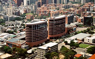
The Centro Simón Bolívar Towers TCSB also known as the Towers of Silence is a building with a pair of 32-story towers, each measuring 103 meters in height, in El Silencio district, Caracas, Venezuela. Built during the time of the presidency of Marcos Pérez Jiménez, the TCSB was opened to the public on December 6, 1954.
La Castellana is a district in Caracas, Venezuela, located in the northeast part of the city, La Castellana is bordered on the south by Chacao, on the east by Altamira (Caracas) neighbourhood, on the west by Caracas Country Club and Campo Alegre neighbourhood and on the north by El Ávila National Park.
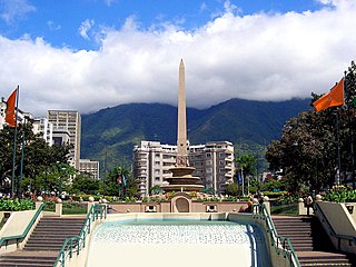
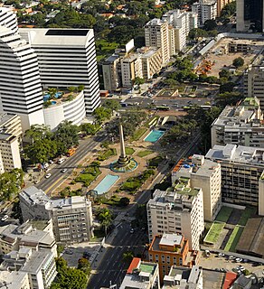
Plaza Francia, also known as "Plaza Altamira", is a public space located in Altamira, east Caracas. It was built at the beginning of the 1940s and opened in August 11, 1945 with the original name of "Plaza Altamira". Is name was later changed due to an agreement between the cities of Caracas and Paris to have a Venezuela Square in Paris and a France Square in Caracas. This square was designed by town planner Luis Roche within the project of "Altamira neighborhood", a wealthy district of Chacao municipality in Miranda States.
Bolívar Square in Caracas is one of the most important and recognized Venezuelan public spaces. It is located in the center of the first 25 blocks of Caracas when it was founded as "Santiago de León de Caracas" in 1567. It is in the historic center of the city in the Cathedral Parish of the Libertador Municipality.

The Sabana Grande district is divided into several middle class neighborhoods located in the Parroquia El Recreo of the Libertador Municipality, in the geographical center of the Metropolitan District of Caracas and owes its name to the old town of Sabana Grande.

El Recreo Shopping Mall is a large shopping mall in the commercial, financial, tourist and cultural district of Sabana Grande, Caracas, Venezuela. According to Top Shopping Centers magazine, the mall averaged three million visitors per month in 2013-2014. At 28 metres (92 ft) and seven floors below grade, it is Latin America's deepest construction and part of the late-1990s real-estate boom in Sabana Grande. El Recreo Shopping Mall was designed by Venezuelan architects Carlos Gómez de Llarena and Moisés Benacerraf. The shopping center's twin towers—the 125-metre (410 ft) Citibank and Movilnet Towers—are the tallest skyscrapers in the Venezuelan capital. The mall is connected to the Gran Meliá Caracas Hotel.

El Cafetal is a neighborhood located in the Baruta Municipality of Caracas, Venezuela.


