Coordinates: 53°35′24″N2°48′25″W / 53.590°N 2.807°W

A geographic coordinate system is a coordinate system that enables every location on Earth to be specified by a set of numbers, letters or symbols. The coordinates are often chosen such that one of the numbers represents a vertical position and two or three of the numbers represent a horizontal position; alternatively, a geographic position may be expressed in a combined three-dimensional Cartesian vector. A common choice of coordinates is latitude, longitude and elevation. To specify a location on a plane requires a map projection.
| Lathom and Burscough | |
|---|---|
| Area | |
| • 1911 | 13,660 acres (55.3 km2) |
| • 1921 | 13,642 acres (55.21 km2) |
| Population | |
| • 1901 | 7,113 |
| • 1921 | 7,633 |
| History | |
| • Origin | local government district |
| • Created | 1894 |
| • Abolished | 1931 |
| • Succeeded by | Ormskirk Urban District |
| Status | urban district |
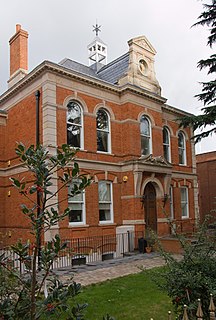
| Government | Lathom and Burscough Urban District Council |
| • HQ | Council Offices, Mill Lane, Lathom |
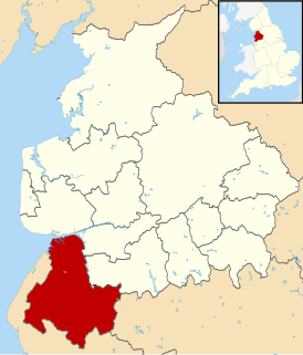
Lathom and Burscough was an urban district in the county of Lancashire from 1894 to 1931. It constituted the civil parishes of Burscough and Lathom, and apart from these two villages also included Newburgh.
In England and Wales, Northern Ireland, and the Republic of Ireland, an urban district was a type of local government district that covered an urbanised area. Urban districts had an elected urban district council (UDC), which shared local government responsibilities with a county council.

Lancashire is a ceremonial county in North West England. The administrative centre is Preston. The county has a population of 1,449,300 and an area of 1,189 square miles (3,080 km2). People from Lancashire are known as Lancastrians.

In England, a civil parish is a type of administrative parish used for local government, they are a territorial designation which is the lowest tier of local government below districts and counties, or their combined form, the unitary authority. Civil parishes can trace their origin to the ancient system of ecclesiastical parishes which historically played a role in both civil and ecclesiastical administration; civil and religious parishes were formally split into two types in the 19th century and are now entirely separate. The unit was devised and rolled out across England in the 1860s.
Lathom Local Government District was formed in 1872 when the parish of Lathom adopted the Local Government Act 1858, and a local board was formed to govern the area. [1] In February 1894 the parish of Burscough was added to the local board's area. The area of the local board was subsequently reconstituted as an urban district by the Local Government Act 1894 as Lathom and Burscough, and an elected urban district council replaced the local board. [2]
Local boards or local boards of health were local authorities in urban areas of England and Wales from 1848 to 1894. They were formed in response to cholera epidemics and were given powers to control sewers, clean the streets, regulate environmental health risks including slaughterhouses and ensure the proper supply of water to their districts. Local boards were eventually merged with the corporations of municipal boroughs in 1873, or became urban districts in 1894.

The Local Government Act 1894 was an Act of the Parliament of the United Kingdom that reformed local government in England and Wales outside the County of London. The Act followed the reforms carried out at county level under the Local Government Act 1888. The 1894 legislation introduced elected councils at district and parish level.
In 1931, the Lathom and Burscough Urban District was abolished under a County Review Order, and its area added to an enlarged Ormskirk Urban District. [2] [3]
The Local Government Act 1929 was an Act of the Parliament of the United Kingdom that made changes to the Poor Law and local government in England and Wales.
Ormskirk was an urban district in the county of Lancashire from 1894 to 1974. It was named after the town of Ormskirk, which constituted its main settlement.