
Sutherland is a historic county, registration county and lieutenancy area in the Highlands of Scotland. Its county town is Dornoch. Sutherland borders Caithness and Moray Firth to the east, Ross-shire and Cromartyshire to the south and the Atlantic to the north and west. Like its southern neighbour Ross-shire, Sutherland has some of the most dramatic scenery in Europe, especially on its western fringe where the mountains meet the sea. These include high sea cliffs, and very old mountains composed of Precambrian and Cambrian rocks.

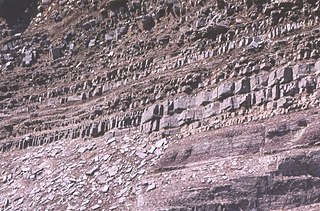
The Moine Thrust Belt or Moine Thrust Zone is a linear tectonic feature in the Scottish Highlands which runs from Loch Eriboll on the north coast 190 kilometres (120 mi) south-west to the Sleat peninsula on the Isle of Skye. The thrust belt consists of a series of thrust faults that branch off the Moine Thrust itself. Topographically, the belt marks a change from rugged, terraced mountains with steep sides sculptured from weathered igneous, sedimentary and metamorphic rocks in the west to an extensive landscape of rolling hills over a metamorphic rock base to the east. Mountains within the belt display complexly folded and faulted layers and the width of the main part of the zone varies up to 10 kilometres (6.2 mi), although it is significantly wider on Skye.

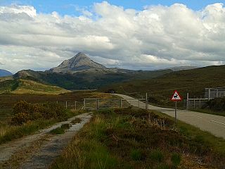
Ben Stack is a mountain in Sutherland, in the northwest of Scotland. It is 721 m (2,365 ft) high. It lies southeast of Laxford Bridge and northwest of Loch More along the A838 road, and just west of Loch Stack.
In geology, the term Torridonian is the informal name for the Torridonian Group, a series of Mesoproterozoic to Neoproterozoic arenaceous and argillaceous sedimentary rocks, which occur extensively in the Northwest Highlands of Scotland. The strata of the Torridonian Group are particularly well exposed in the district of upper Loch Torridon, a circumstance which suggested the name Torridon Sandstone, first applied to these rocks by James Nicol. Stratigraphically, they lie unconformably on gneisses of the Lewisian complex and their outcrop extent is restricted to the Hebridean Terrane.
The Northwest Highlands are located in the northern third of Scotland that is separated from the Grampian Mountains by the Great Glen. The region comprises Wester Ross, Assynt, Sutherland and part of Caithness. The Caledonian Canal, which extends from Loch Linnhe in the south-west, via Loch Ness to the Moray Firth in the north-east splits this area from the rest of the country. The city of Inverness and the town of Fort William serve as gateways to the region from the south.

Ben More Assynt is a mountain in Assynt in the far north-west of Scotland, 30 kilometres north-northeast of Ullapool. The name translates as "big mountain of Assynt", and with a height of 998 metres it is the highest point in Sutherland.

Eriboll is a village in Sutherland, Scotland. The village is situated on the south eastern shore of Loch Eriboll, in the northern part of the former county of Sutherland.

Fanagmore is a hamlet in Sutherland, Highland, in far northwestern Scotland. It lies on the south shore of Loch Laxford, an inlet of the Atlantic Ocean. Fanagmore consists of three properties, a few farm buildings, a boat launch and a small harbour. There are tourist cruises from the nearby hamlet of Tarbet to Handa Island.

The North West Highlands Geopark is a geopark in the Scottish Highlands. Awarded UNESCO geopark status in 2004, it was Scotland's first geopark, featuring some of the oldest rocks in Europe, around 3,000 million years old. The park contains many notable geological features, such as the Moine Thrust Belt and Smoo Cave and covers an area of around 2,000 square kilometres (770 sq mi).

Loch Alsh is a sea inlet between the isle of Skye in the Inner Hebrides and the Northwest Highlands of Scotland. The name is also used to describe the surrounding country and the feudal holdings around the loch. The area is rich in history, and is increasingly popular with tourists.

Loch Veyatie is a large freshwater loch in north-west Scotland. It stretches for 6 km north-westwards from the settlement of Elphin, and lies between Suilven and Cùl Mòr. The loch is located in an area known as the Assynt-Coigach National Scenic Area, one of 40 such areas in Scotland.
The Moine Supergroup is a sequence of Neoproterozoic metamorphic rocks that form the dominant outcrop of the Scottish Highlands between the Moine Thrust Belt to the northwest and the Great Glen Fault to the southeast. The sequence is metasedimentary in nature and was metamorphosed and deformed in a series of tectonic events during the Late Proterozoic and Early Paleozoic. It takes its name from A' Mhòine, a peat bog in northern Sutherland.
Rhiconich is a remote hamlet, located at the head of Loch Inchard, in Sutherland, Scottish Highlands in the Scottish council area of Highland. Rhiconich is situated 3 miles (4.8 km) north-east of Laxford Bridge and 11 miles (18 km) south-west of Durness on the A838 road. The B801 at Richonich links the village of Kinlochbervie and associated crofting townships such as Oldshoremore to the A838.
Badcall comprises two remote hamlets, called Lower Badcall and Upper Badcall. Upper Badcall, a crofting township, is the larger of the two and is situated on the western shore of Badcall Bay. Lower Badcall is located less than 1 mile to the east on the eastern shore of Badcall Bay. Badcall is on the west coast of Sutherland, Scottish Highlands and is in the Scottish council area of Highland.

The Lewisian complex or Lewisian gneiss is a suite of Precambrian metamorphic rocks that outcrop in the northwestern part of Scotland, forming part of the Hebridean Terrane and the North Atlantic Craton. These rocks are of Archaean and Paleoproterozoic age, ranging from 3.0–1.7 billion years (Ga). They form the basement on which the Torridonian and Moine Supergroup sediments were deposited. The Lewisian consists mainly of granitic gneisses with a minor amount of supracrustal rocks. Rocks of the Lewisian complex were caught up in the Caledonian orogeny, appearing in the hanging walls of many of the thrust faults formed during the late stages of this tectonic event.

The Hebridean Terrane is one of the terranes that form part of the Caledonian orogenic belt in northwest Scotland. Its boundary with the neighbouring Northern Highland Terrane is formed by the Moine Thrust Belt. The basement is formed by Archaean and Paleoproterozoic gneisses of the Lewisian complex, unconformably overlain by the Neoproterozoic Torridonian sediments, which in turn are unconformably overlain by a sequence of Cambro–Ordovician sediments. It formed part of the Laurentian foreland during the Caledonian continental collision.

The Laxford Bridge is a stone arch bridge in Sutherland, Scotland which carries the A838 across the River Laxford north to Rhiconich and Durness.
North West Sutherland is a national scenic area (NSA) covering the mountains and coastal scenery of the northwestern part of the county of Sutherland in the highlands of Scotland. The designated area covers the mountains of Foinaven, Arkle and Ben Stack as well as the coastal scenery surrounding Loch Laxford and Handa Island. It is one of 40 such areas in Scotland, which are defined so as to identify areas of exceptional scenery and to ensure its protection by restricting certain forms of development. The North West Sutherland NSA covers 26,565 ha in total, consisting of 23,415 ha of land with a further 3,151 ha being marine.
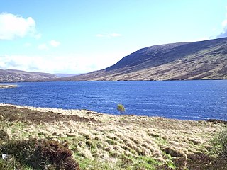
Loch Merkland is a large long inland loch in Sutherland, Northern Scotland. It is located adjacent to the A838 main road which provides almost all access to the Loch and the Merkland Lodge to the south of it. There are many trails and hiking paths in the area, as per usual in the highlands of Scotland. On the Banks just above the Lodge there's also Merkland Cottage meaning there are residents around the Loch.


