
Mandasa is a village in Srikakulam district of the Indian state of Andhra Pradesh. Mandasa is also known by the name Manjusha in Odia. It was ruled by erstwhile odia zamindar Rajamani royal family during British Raj. Srinivasa Rajamani was the famous Ruling chief Rajah of this estate.

Srikakulam district is one of the twenty-six districts of the Indian state of Andhra Pradesh, located in the Uttarandhra region of the state, with its headquarters located at Srikakulam. It is one of the six districts, located in the extreme northeastern direction of the state. It was under Ganjam district till 1936 April 1, then merged under Vizagapatam district in Madras state. Srikakulam district forms the core area of Kalinga where most of its historical capitals like Kalinganagari, pithunda, Dantapuram are located.

Sompeta is a census town in Srikakulam district of the Indian state of Andhra Pradesh. It is the mandal headquarters of Sompeta mandal in Tekkali revenue division.

Kaikaluru is a town in Eluru district of the Indian state of Andhra Pradesh. Kaikalur is home to Kolleru Lake, one of the largest freshwater lakes in India, covering about 90,100 hectares and is a tourist attraction.
Kotabommali is a mandal in the Srikakulam district of the Indian state of Andhra Pradesh.
Nandigam is a village near major town Palasa in Srikakulam district of the Indian state of Andhra Pradesh. It is located in Nandigam mandal.

Narasannapeta is a census town in Srikakulam district of the Indian state of Andhra Pradesh. It is the mandal headquarters of Narasannapeta mandal in Srikakulam revenue division. 43 villages are there under the administrative division of Narasannapeta.
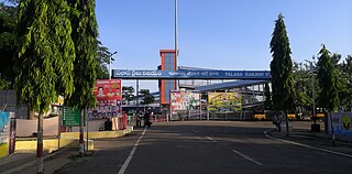
Palasa is one of the twin towns located in the Srikakulam district of Andhra Pradesh, India. The town is situated between Srikakulam and Berhampur. It is categorized as the second grade municipality. Also the town serves as the headquarters of Palasa Mandal.

Pathapatnam is a town in Srikakulam district of the Indian state of Andhra Pradesh. It is located in Pathapatnam mandal of Tekkali revenue division. Pathapatnam is located on the border of Srikakulam district of Andhra Pradesh and Gajapati district of Odisha. Parlakhemundi, the headquarters of Gajapati District, can be considered as twin town of Pathapatnam because of its close proximity. It is located around 65 km from srikakulam. It was the old capital of Paralakhemundi Gajapati Maharajah of his erstwhile kingdom.
Vajrapu-kotturu is a village in Srikakulam district of the Indian state of Andhra Pradesh. Vajrapukotturu mandal is bordered by Mandasa, Palasa, Nandigam and Santha Bommali mandals of Srikakulam district and has a long coastline off Bay of Bengal. Bendi Gedda river joins the sea after forming a lagoon in this mandal area.
Naupada is a village located in Santha Bommali mandal of Srikakulam district near to major town palasa, and Tekkali constituency in Andhra Pradesh, India. It is famous for salt fields and called the "Salt Bowl of Andhra Pradesh". It is better known for its railway junction station.
Harichandapuram is an Indian village and panchayat, located in Kotabommali mandal in Srikakulam district, Andhra Pradesh, India.
Urlam village is located in Narasannapeta mandal in Srikakulam district, Andhra Pradesh, India.

Pendurthi is a neighbourhood in the city of Visakhapatnam, India. The neighbourhood is considered as the major residential and commercial area in the city. It is located within the jurisdiction of the Greater Visakhapatnam Municipal Corporation, which is responsible for the civic amenities in Pendurthi. It is located on the west fringe of Visakhapatnam city. Pendurthi is one of the peaceful neighborhoods of Western Vizag. The pincode of Pendurthi is 531173.
Fareed Peta is a village in the Etcherla Mandalam in Srikakulam District in the state of Andhra Pradesh in India.
Haripuram is a village in Mandasa mandal of Srikakulam district, Andhra Pradesh, India.
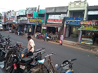
Kasibugga is a twin-town in Srikakulam district of the Indian state of Andhra Pradesh. It is a municipality and the part in mandal of Palasa.

Palasa Assembly constituency is a constituency in Srikakulam district of Andhra Pradesh that elects representatives to the Andhra Pradesh Legislative Assembly in India. It is one of the seven assembly segments of the Srikakulam Lok Sabha constituency.
Kantragada is a village in Palasa mandal, Srikakulam district in the state of Andhra Pradesh, India. It is located on the border of Andhra Pradesh and Orissa which over 1.5 km away. The village established on the water stream of Varahalagadda during mid 19th century during British colonial period, people migrated from near by village Goppili. Kantragada geographical area was a part of Tharlakota kingdom under Kalingas.
Jarjangi is a Panchayath village in Kotabommali mandal, Srikakulam district, in the Indian state of Andhra Pradesh. The Postal Index Code of this village is 532195.
